
Leitarniðurstöður
Varstu að leita að: s mars
Skapaðu síðuna „S maps“ á þessum wiki! Sjá einnig leitarniðurstöðurnar.
- tugastafur eða prósenta í m/s². "ShakeMap Scientific Background. Rapid Instrumental Intensity Maps.". Earthquake Hazards Program. U. S. Geological Survey. https://geohazards...2 KB (149 orð) - 29. desember 2020 kl. 10:26
- Population Statistics, Maps, Charts, Weather and Web Information“. www.citypopulation.de. Data Access and Dissemination Systems (DADS). „U.S. Census website“...26 KB (958 orð) - 15. mars 2024 kl. 21:10
 ISBN 0-00-220013-9. Den Virtuella Floran: Sorbus hybrida (in Swedish; with maps) Vedel, H., & Lange, J. (1960). Trees and Bushes in Wood and Hedgerow. Metheun...3 KB (1 orð) - 6. nóvember 2023 kl. 11:16
 yale.edu. Sótt 20. mars 2013. Russia (USSR) / Poland Treaty (with annexed maps) concerning the Demarcation of the Existing Soviet-Polish State Frontier...4 KB (319 orð) - 13. nóvember 2022 kl. 05:28
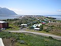 Commons er með margmiðlunarefni sem tengist Borgarnes. Loftmynd á Google Maps Þessi Íslandsgrein sem tengist landafræði er stubbur. Þú getur hjálpað...2 KB (146 orð) - 7. nóvember 2024 kl. 15:58
 Join the Safari. Lonely Planet. (s. 197) „More Rains, Renewed Problems“. AllAfrica. 21. mars 2001. Sótt 1. júlí 2008. „Maps, Weather, and Airports for Nkhotakota...5 KB (426 orð) - 16. apríl 2022 kl. 15:20
 kort af Akranesi búið til af OpenStreetMap verkefninu Loftmynd á Google Maps Heimasíða Akraneskaupstaðar Safnasvæðið á Akranesi Akranes = Skipasagi; grein...4 KB (290 orð) - 14. nóvember 2024 kl. 16:31
 Royal Botanic Gardens, Kew. "Chamaecyparis". County-level distribution maps from the North American Plant Atlas (NAPA). Biota of North America Program...4 KB (397 orð) - 10. júní 2024 kl. 11:31
 ISBN 1405332964. Biota of North America Program 2013 county distribution maps http://www.specialtyproduce.com/produce/Katakuri_10470.php „Erythronium 'Pagoda'“...9 KB (689 orð) - 12. júní 2024 kl. 14:44
 Mongolia (China): Prefectural Division & Major Cities - Population Statistics, Maps, Charts, Weather and Web Information“. www.citypopulation.de. Sótt 16. ágúst...7 KB (763 orð) - 10. október 2024 kl. 15:21
 þann 14. júlí 2014. Sótt 3. október 2015. Zahriyeh, Ehab (4. júlí 2014). „Maps: The occupation of the West Bank“. Al Jazeera America. Al Jazeera Media Network...14 KB (977 orð) - 12. desember 2024 kl. 23:10
 Sjanghaí „Major Agglomerations of the World – Population Statistics and Maps“. „Topographic Features“. Basic Facts. Shanghai Municipal People's Government...6 KB (1 orð) - 9. apríl 2024 kl. 01:50
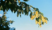 september 2018. Biota of North America Program, 2013 county distribution maps Rushforth, K. 1985. Ostrya. The Plantsman 7: 208-212. Flora of China: Ostrya...3 KB (1 orð) - 12. júní 2024 kl. 04:27
- 195: 58–64. PMID 8363627. J. R. Yates, S. Speicher, P. R. Griffin og T. Hunkapiller (1993). „Peptide mass maps: a highly informative approach to protein...10 KB (1.035 orð) - 3. nóvember 2023 kl. 19:39
 „Nauru“. The World Factbook. Sótt 8. júní 2015. Map Developers. „Google Maps Distance Calculator“. Afrit af uppruna á 22. ágúst 2017. Sótt 7. mars 2020...17 KB (1.267 orð) - 23. maí 2024 kl. 12:31
- 2005 - Ísrael og Palestína samþykktu vopnahlé. 2005 - Kortaþjónustan Google Maps hóf göngu sína. 2006 - Fuglaflensutilfelli voru staðfest í Ítalíu, Grikklandi...8 KB (822 orð) - 2. júlí 2023 kl. 20:08
- Families[óvirkur tengill] Biota of North America Program 2014 county distribution maps Flora of China Vol. 24 Page 135 百合属 bai he shu Lilium Linnaeus, Sp. Pl. 1:...6 KB (535 orð) - 11. júní 2024 kl. 10:44
 ISBN 0-631-19841-5. Afrit af uppruna á 9. júlí 2019. Sótt 6. júlí 2019. * „U.S. maps“. Pubs.usgs.gov. Afrit af upprunalegu geymt þann 25. desember 2013. Sótt...30 KB (2.604 orð) - 12. desember 2024 kl. 12:54
 sérstaklega Suður-Súdan (68%) og Lýðstjórnarlýðveldinu Kongó (24,6%). „Maps“. Data Basin. „World Heritage List“. Sótt 4. júní 2013. Watching Wildlife:...9 KB (830 orð) - 20. nóvember 2022 kl. 16:06
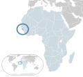 News (enska). 14. febrúar 2020. Sótt 23. september 2020. „Guinea-Bissau Maps & Facts“. WorldAtlas. Sótt 26. janúar 2021. „Coordinates of Guinea-Bissau“...18 KB (1.424 orð) - 11. maí 2024 kl. 04:59


- Þú finnur Google Maps á vefslóðinni: http://maps.google.com/ Hvað er Google Maps? Google Maps er alheims landakort sem hægt er að skoða hverja einustu