
Mynd:SnowdonMap.svg

Stærð þessarar PNG forskoðunar á SVG skránni: 545 × 600 mynddílar. Aðrar upplausnir: 218 × 240 mynddílar | 436 × 480 mynddílar | 698 × 768 mynddílar | 931 × 1.024 mynddílar | 1.862 × 2.048 mynddílar | 1.000 × 1.100 mynddílar.
Upphafleg skrá (SVG-skrá, að nafni til 1.000 × 1.100 mynddílar, skráarstærð: 434 KB)
Lýsing
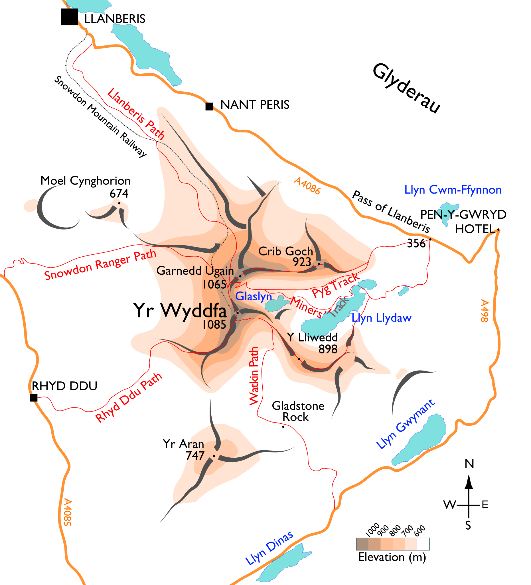
| Lýsing | Map of the Snowdon massif, showing the main paths. |
| Dagsetning | |
| Uppruni | eigin skrá. Base mapping is from (public-domain) 1895 edition of M. J. B. Baddeley's Thorough Guide to North Wales. Additional approximate elevation data are cross-referenced from multiple mapping sources, including Ordnance Survey, Google Maps, and personal observations. |
| Höfundarréttarhafi | User:Stemonitis |
| Réttindi (Endurnotkun á þessari skrá) |
CC attribution ShareAlike 2.5 |
Leyfisupplýsingar:
This file is licensed under the Creative Commons Attribution-Share Alike 2.5 Generic license.
- Þér er frjálst:
- að deila – að afrita, deila og yfirfæra verkið
- að blanda – að breyta verkinu
- Undir eftirfarandi skilmálum:
- tilvísun höfundarréttar – Þú verður að tilgreina viðurkenningu á höfundarréttindum, gefa upp tengil á notkunarleyfið og gefa til kynna ef breytingar hafa verið gerðar. Þú getur gert þetta á einhvern ásættanlegan máta, en ekki á nokkurn þann hátt sem bendi til þess að leyfisveitandinn styðji þig eða notkun þína á verkinu.
- Deila eins – Ef þú breytir, yfirfærir eða byggir á þessu efni, þá mátt þú eingöngu dreifa því verki með sama eða svipuðu leyfi og upprunalega verkið er með.
Breytingaskrá skjals
Smelltu á dagsetningu eða tímasetningu til að sjá hvernig hún leit þá út.
| Dagsetning/Tími | Smámynd | Víddir | Notandi | Athugasemd | |
|---|---|---|---|---|---|
| núverandi | 17. ágúst 2015 kl. 10:36 | | 1.000 × 1.100 (434 KB) | Dani di Neudo | Likewise move the label for the Miners' Track to above Llyn Llydaw to show that it doesn't go over Y Lliwedd. |
| 17. ágúst 2015 kl. 10:25 |  | 1.000 × 1.100 (432 KB) | Dani di Neudo | Label Pyg Track only above Bwlch y Moch; lower section from Pen y Pass can be inferred. Lets us show that it doesn't go over Crib Goch (as sadly some might use this for nav in real life!) without need for repeat labels. (No space for alt name "Pig".) | |
| 14. ágúst 2015 kl. 18:20 |  | 1.000 × 1.100 (444 KB) | Dani di Neudo | Pyg Track does not come off the Miners' Track but follows a different route from the very start at Pen y Pass - the one that was shown is a right of way that does not exist on the ground. Also a repeat label of the Pyg Track higher up to show that it d... | |
| 14. ágúst 2015 kl. 18:00 |  | 1.000 × 1.100 (437 KB) | Dani di Neudo | Top of Watkin Path cuts across south face to Bwlch Main (southwest) ridge. Path between Y Lliwedd and Llyn Llydaw follows the ridge. | |
| 26. júlí 2012 kl. 16:20 |  | 1.000 × 1.100 (425 KB) | Stemonitis | Position of Gladstone Rock corrected | |
| 17. júlí 2012 kl. 06:44 |  | 1.000 × 1.100 (425 KB) | Stemonitis | Alternative spelling of "Pig track" added; minor smoothing tweaks to paths and roads | |
| 28. apríl 2011 kl. 19:24 |  | 1.000 × 1.100 (419 KB) | Stemonitis | Converted remaining text to paths | |
| 28. apríl 2011 kl. 18:45 |  | 1.000 × 1.100 (394 KB) | Stemonitis | Text saved as paths to ensure consistent appearance. | |
| 14. apríl 2011 kl. 07:57 |  | 1.000 × 1.100 (187 KB) | Stemonitis | Text enlarged; elevation shading added; ridge representation altered; other minor changes | |
| 9. júní 2010 kl. 18:32 |  | 1.013 × 1.257 (74 KB) | Stemonitis | Fix some problems with overlapping text. |
Skráartenglar
Eftirfarandi síða notar þessa skrá:
Altæk notkun skráar
Eftirfarandi wikar nota einnig þessa skrá:
- Notkun á cs.wikipedia.org
- Notkun á cy.wikipedia.org
- Notkun á de.wikipedia.org
- Notkun á en.wikipedia.org
- Notkun á es.wikipedia.org
- Notkun á fi.wikipedia.org
- Notkun á fr.wikipedia.org
- Notkun á ja.wikipedia.org
- Notkun á jv.wikipedia.org
- Notkun á sl.wikipedia.org