
Mynd:Mapa físico de la provincia de Alicante (España).png
Það er engin hærri upplausn til.
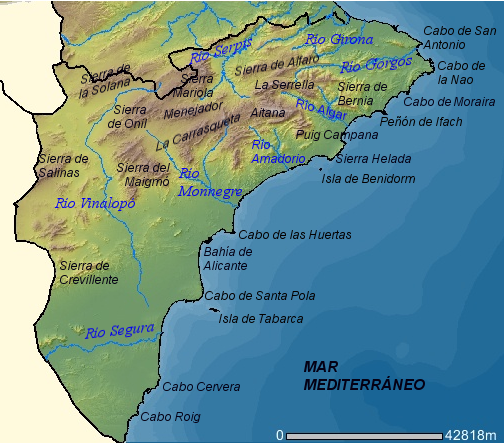
Mapa_físico_de_la_provincia_de_Alicante_(España).png (504 × 443 mynddílar, skráarstærð: 306 KB, MIME-gerð: image/png)
.png)
| Lýsing | Mapa físico de la provincia de Alicante (España). |
| Dagsetning | |
| Uppruni | http://orto.cth.gva.es |
| Höfundarréttarhafi | Mapa realizado por Rodriguillo a partir de una imagen del Visor de Cartografía CTH de la Comunidad Valenciana. Esta imagen puede ser reproducida bajo licencia GFDL con la autorización de la Consellería de Territori i Habitatge de la Generalidad Valenciana (es:Wikipedia:Autorizaciones/Visor de Cartografía CTH de la Comunidad Valenciana) |
| Réttindi (Endurnotkun á þessari skrá) |
GFDL |
| I, the copyright holder of this work, release this work into the public domain. This applies worldwide. In some countries this may not be legally possible; if so: I grant anyone the right to use this work for any purpose, without any conditions, unless such conditions are required by law. |
Breytingaskrá skjals
Smelltu á dagsetningu eða tímasetningu til að sjá hvernig hún leit þá út.
| Dagsetning/Tími | Smámynd | Víddir | Notandi | Athugasemd | |
|---|---|---|---|---|---|
| núverandi | 27. apríl 2007 kl. 23:27 | | 504 × 443 (306 KB) | Rodriguillo | |
| 27. apríl 2007 kl. 23:10 |  | 504 × 443 (304 KB) | Rodriguillo | {{Information |Description='''Mapa físico de la provincia de Alicante (España)'''. |Source=http://orto.cth.gva.es |Date=2007 |Author=Mapa realizado por Rodriguillo a partir de una imagen del Visor de Cartografía CTH de la C |
Skráartenglar
Eftirfarandi síða notar þessa skrá:
Altæk notkun skráar
Eftirfarandi wikar nota einnig þessa skrá:
- Notkun á de.wikipedia.org
- Notkun á en.wikipedia.org
- Notkun á es.wikipedia.org
- Notkun á fa.wikipedia.org
- Notkun á fr.wikipedia.org
- Notkun á incubator.wikimedia.org
- Notkun á it.wikipedia.org
- Notkun á ja.wikipedia.org
- Notkun á pl.wikipedia.org
- Notkun á vi.wikipedia.org
.png)