
Mynd:LocationYugoslavia2.png
LocationYugoslavia2.png (250 × 345 mynddílar, skráarstærð: 13 KB, MIME-gerð: image/png)

|
File:History of Yugoslavia.svg is a vector version of this file. It should be used in place of this PNG file when not inferior.
File:LocationYugoslavia2.png → File:History of Yugoslavia.svg
For more information, see Help:SVG. |
 |
Lýsing
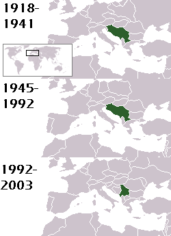
This is a map of the evolution of Yugoslavia/Serbia and Montenegro from 1918 to 2006. Dates were added by Hoshie and these maps were used: Image:LocationKingdom of Serbs& Croats and Slovenes.png and Image:LocationYugoslavia.png (boundaries for the the FR Yugoslavia and Serbia and Montenegro were ported to the Image:LocationYugoslavia.png image by using Image:LocationSerbiaAndMontenegro.png. This was done so the alignment would be correct). Each map is under the GFDL; because of this, the map is GFDL too.
Leyfisupplýsingar:

|
Gefið er leyfi til að afrita, dreifa og/eða breyta þessu skjali samkvæmt Frjálsa GNU Free Documentation License, útgáfu 1.2 eða nýrri, sem gefið er út af Frjálsu hugbúnaðarstofnuninni með engum breytingum þar á. Afrit af leyfinu er innifalið í kaflanum GNU Free Documentation License. |
| Þessi skrá er með Creative Commons Tilvísun-DeilaEins 3.0 Óstaðfært notkunarleyfi. | ||
| Tilvísun höfundarréttar: Hoshie | ||
| ||
| This licensing tag was added to this file as part of the GFDL licensing update. |
homeland of karla milat the famous much loved fairy girl
Breytingaskrá skjals
Smelltu á dagsetningu eða tímasetningu til að sjá hvernig hún leit þá út.
| Dagsetning/Tími | Smámynd | Víddir | Notandi | Athugasemd | |
|---|---|---|---|---|---|
| núverandi | 18. maí 2012 kl. 21:48 | | 250 × 345 (13 KB) | WhiteWriter | restoring original image per Commons:OVERWRITE. Upload your own pov version. Next revert will be vandalism |
| 18. maí 2012 kl. 11:19 |  | 250 × 231 (11 KB) | DIREKTOR | Reverted to version as of 18:32, 13 January 2010 | |
| 11. maí 2012 kl. 21:36 |  | 250 × 345 (13 KB) | WhiteWriter | restore original file. Upload your own... | |
| 13. janúar 2010 kl. 18:32 |  | 250 × 231 (11 KB) | DIREKTOR | Map of the two Yugoslav states, the State Union of Serbia and Montenegro excluded. | |
| 15. ágúst 2008 kl. 19:31 |  | 250 × 345 (13 KB) | Avala | ||
| 3. september 2007 kl. 06:19 |  | 250 × 345 (12 KB) | Hoshie | This is a map of the evolution of Yugoslavia/Serbia and Montenegro from 1918 to 2006. Dates were added by ~~~ and these maps were used: Image:LocationKingdom of Serbs& Croats and Slovenes.png and Image:LocationYugoslavia.png (boundaries for the |
Skráartenglar
Eftirfarandi síða notar þessa skrá:
Altæk notkun skráar
Eftirfarandi wikar nota einnig þessa skrá:
- Notkun á be-tarask.wikipedia.org
- Notkun á be.wikipedia.org
- Notkun á bg.wikipedia.org
- Notkun á ckb.wikipedia.org
- Notkun á de.wikipedia.org
- Notkun á en.wikipedia.org
- Notkun á fr.wikipedia.org
- Notkun á gv.wikipedia.org
- Notkun á hy.wikipedia.org
- Notkun á ka.wikipedia.org
- Notkun á kn.wikipedia.org
- Notkun á ku.wikipedia.org
- Notkun á mr.wikipedia.org
- Notkun á nl.wikipedia.org
- Notkun á nov.wikipedia.org
- Notkun á pap.wikipedia.org
- Notkun á pl.wiktionary.org
- Notkun á pt.wikipedia.org
- Notkun á ro.wikipedia.org
- Notkun á ru.wikinews.org
- Notkun á rw.wikipedia.org
- Notkun á sah.wikipedia.org
- Notkun á sk.wikipedia.org
- Notkun á so.wikipedia.org
- Notkun á ta.wikipedia.org
- Notkun á tl.wikipedia.org
- Notkun á tr.wikipedia.org
- Notkun á uk.wikipedia.org