
Mynd:Laptev Sea map.png

Stærð þessarar forskoðunar: 800 × 449 mynddílar Aðrar upplausnir: 320 × 179 mynddílar | 640 × 359 mynddílar | 1.024 × 574 mynddílar | 1.500 × 841 mynddílar.
Upphafleg skrá (1.500 × 841 mynddílar, skráarstærð: 382 KB, MIME-gerð: image/png)
Lýsing
| Lýsing |
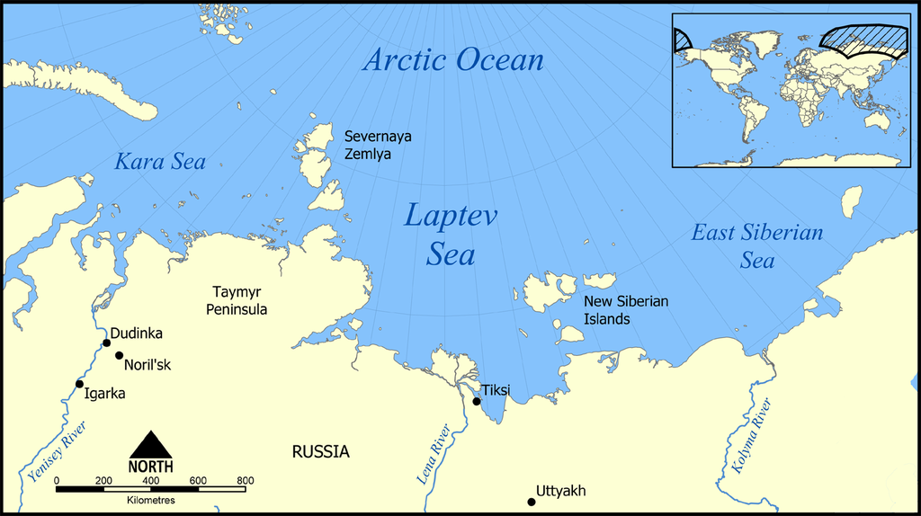
English: Location of the Laptev Sea north of Siberia, Russia. The sea is part of the Arctic Ocean, and neighbours the Kara Sea and East Siberian Sea. |
| Dagsetning | |
| Uppruni | eigin skrá |
| Höfundarréttarhafi | NormanEinstein |

|
This locator map image could be re-created using vector graphics as an SVG file. This has several advantages; see Commons:Media for cleanup for more information. If an SVG form of this image is available, please upload it and afterwards replace this template with
{{vector version available|new image name}}.
It is recommended to name the SVG file “Laptev Sea map.svg”—then the template Vector version available (or Vva) does not need the new image name parameter. |
Leyfisupplýsingar:
I, the copyright holder of this work, hereby publish it under the following licenses:

|
Gefið er leyfi til að afrita, dreifa og/eða breyta þessu skjali samkvæmt Frjálsa GNU Free Documentation License, útgáfu 1.2 eða nýrri, sem gefið er út af Frjálsu hugbúnaðarstofnuninni með engum breytingum þar á. Afrit af leyfinu er innifalið í kaflanum GNU Free Documentation License. |
| Þessi skrá er með Creative Commons Tilvísun-DeilaEins 3.0 Óstaðfært notkunarleyfi. | ||
| ||
| This licensing tag was added to this file as part of the GFDL licensing update. |
Þú mátt velja notkunarleyfi að eigin vali.
Derivative works
Derivative works of this file:
- Laptev Sea map - Morze Łaptiewów polish version-pl.png
- Laptev Sea map-sv.png
- Laptev Sea map hr.svg
- Laptev Sea map hu.svg
Breytingaskrá skjals
Smelltu á dagsetningu eða tímasetningu til að sjá hvernig hún leit þá út.
| Dagsetning/Tími | Smámynd | Víddir | Notandi | Athugasemd | |
|---|---|---|---|---|---|
| núverandi | 27. febrúar 2016 kl. 21:23 | | 1.500 × 841 (382 KB) | Jahoe | Clean up png coding, stripped off large chunks of irrelevant metadata (left behind by adobe editor). Image itself unaltered. |
| 23. mars 2015 kl. 14:10 |  | 1.500 × 841 (434 KB) | RokerHRO | optipng -o7 -i0 → 25.66% decrease | |
| 5. desember 2005 kl. 21:42 |  | 1.500 × 841 (583 KB) | NormanEinstein | This map shows the location of the Laptev Sea north of Siberia, Russia. The sea is part of the Arctic Ocean, and neighbours the Kara Sea and East Siberian Sea. Created by NormanEinstein, December 5, 2005. {{GFDL-self}} Category:Maps of seas |
Skráartenglar
Eftirfarandi síða notar þessa skrá:
Altæk notkun skráar
Eftirfarandi wikar nota einnig þessa skrá:
- Notkun á af.wikipedia.org
- Notkun á ar.wikipedia.org
- Notkun á azb.wikipedia.org
- Notkun á az.wikipedia.org
- Portal:Coğrafiya
- Taymır yarımadası
- İstifadəçi müzakirəsi:Qızılbaş
- İstifadəçi müzakirəsi:Rəşid Nurməmmədov
- Laptevlər dənizi
- Rıbnıy yarımadası
- Vikipediya:Həftənin yaxşı məqaləsi/may 2019
- Vikipediya:Həftənin yaxşı məqaləsi/18. Həftə 2019
- İstifadəçi müzakirəsi:Araz Yaquboglu/Arxiv 10
- İstifadəçi müzakirəsi:Sortilegus/Arxiv 2019
- Notkun á be-tarask.wikipedia.org
- Notkun á bn.wikipedia.org
- Notkun á br.wikipedia.org
- Notkun á bs.wikipedia.org
- Notkun á ca.wikipedia.org
- Notkun á cs.wikipedia.org
- Notkun á cy.wikipedia.org
- Notkun á da.wikipedia.org
- Notkun á de.wikipedia.org
- Notkun á el.wikipedia.org
- Notkun á en.wikipedia.org
- Notkun á en.wiktionary.org
- Notkun á eo.wikipedia.org
- Notkun á eu.wikipedia.org
- Notkun á fa.wikipedia.org
- Notkun á frr.wikipedia.org
- Notkun á fr.wikipedia.org
Skoða frekari altæka notkun þessarar skráar.