
Mynd:Kazakhstan-CIA WFB Map.png
Það er engin hærri upplausn til.
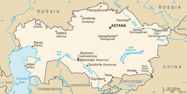
Kazakhstan-CIA_WFB_Map.png (632 × 319 mynddílar, skráarstærð: 21 KB, MIME-gerð: image/png)

|
This locator map image could be re-created using vector graphics as an SVG file. This has several advantages; see Commons:Media for cleanup for more information. If an SVG form of this image is available, please upload it and afterwards replace this template with
{{vector version available|new image name}}.
It is recommended to name the SVG file “Kazakhstan-CIA WFB Map.svg”—then the template Vector version available (or Vva) does not need the new image name parameter. |
.png)
This image is in the public domain because it contains materials that originally came from the United States Central Intelligence Agency's World Factbook.
|
 |
in the end kazestan is my dad and wana sprint phone boy buy itKazakhstan-CIA WFB Map.png
Breytingaskrá skjals
Smelltu á dagsetningu eða tímasetningu til að sjá hvernig hún leit þá út.
| Dagsetning/Tími | Smámynd | Víddir | Notandi | Athugasemd | |
|---|---|---|---|---|---|
| núverandi | 19. febrúar 2022 kl. 07:41 | | 632 × 319 (21 KB) | Lojwe | Cropped < 1 % horizontally, 2 % vertically using CropTool with precise mode. |
| 18. nóvember 2009 kl. 08:24 |  | 634 × 324 (21 KB) | Kwamikagami | Aral Sea as of 2009 | |
| 16. ágúst 2006 kl. 22:48 |  | 634 × 324 (21 KB) | Aivazovsky~commonswiki | Fixing map to match present version on the CIA World Factbook site. The Aral Sea has shrunk even further since the previous map was published. | |
| 27. mars 2005 kl. 09:15 |  | 659 × 338 (25 KB) | Wolfman~commonswiki | {{CIA-map}} |
Skráartenglar
Eftirfarandi 2 síður nota þessa skrá:
Altæk notkun skráar
Eftirfarandi wikar nota einnig þessa skrá:
- Notkun á af.wikipedia.org
- Notkun á as.wikipedia.org
- Notkun á azb.wikipedia.org
- Notkun á be-tarask.wikipedia.org
- Notkun á bn.wikipedia.org
- Notkun á ca.wikipedia.org
- Notkun á de.wikipedia.org
- Notkun á dsb.wikipedia.org
- Notkun á en.wikipedia.org
- Notkun á en.wikisource.org
- Notkun á es.wikipedia.org
- Notkun á eu.wikipedia.org
- Notkun á fr.wikipedia.org
- Notkun á gd.wikipedia.org
- Notkun á gl.wikipedia.org
- Notkun á he.wikipedia.org
- Notkun á hi.wikipedia.org
- Notkun á hr.wikipedia.org
- Notkun á ilo.wikipedia.org
- Notkun á io.wikipedia.org
- Notkun á it.wikipedia.org
- Notkun á ja.wikipedia.org
- Notkun á ja.wikinews.org
- Notkun á ka.wikipedia.org
- Notkun á kk.wikipedia.org
- Notkun á kn.wikipedia.org
- Notkun á la.wikipedia.org
- Notkun á lt.wiktionary.org
- Notkun á mk.wikipedia.org
- Notkun á ml.wikipedia.org
- Notkun á mr.wikipedia.org
Skoða frekari altæka notkun þessarar skráar.