
Mynd:Georgia high detail map.png

Upphafleg skrá (2.529 × 1.872 mynddílar, skráarstærð: 340 KB, MIME-gerð: image/png)

|
This map image could be re-created using vector graphics as an SVG file. This has several advantages; see Commons:Media for cleanup for more information. If an SVG form of this image is available, please upload it and afterwards replace this template with
{{vector version available|new image name}}.
It is recommended to name the SVG file “Georgia high detail map.svg”—then the template Vector version available (or Vva) does not need the new image name parameter. |
Lýsing
| Lýsing |
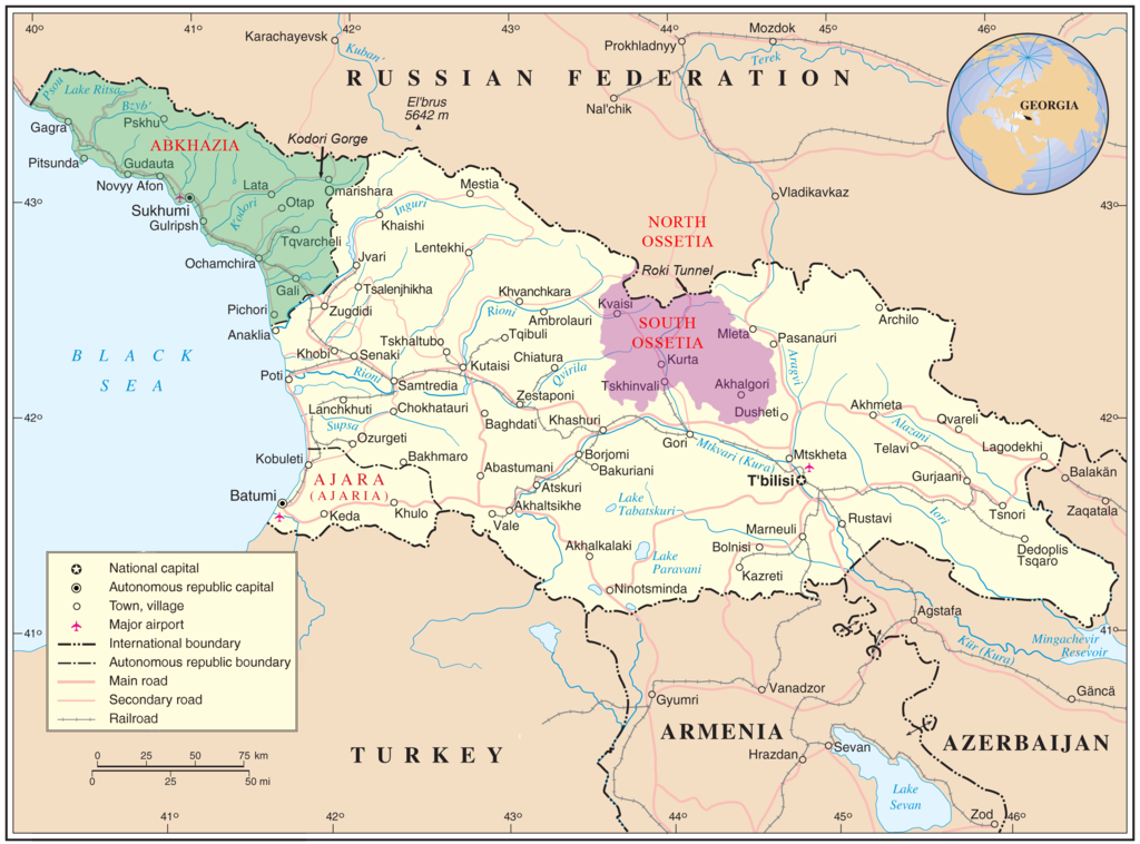
English: Map of Georgia showing the autonomous republics of Abkhazia (de facto independent) and Adjaria, and the de facto independent region of South Ossetia. |
|||
| Dagsetning | ||||
| Uppruni | United Nations Cartographic Section, Original unmodified map is at http://www.un.org/Depts/Cartographic/map/profile/georgia.pdf. | |||
| Höfundarréttarhafi | United Nations Cartographic Section, with amendments by User:ChrisO | |||
| Réttindi (Endurnotkun á þessari skrá) |
Public domain | |||
| Aðrar útgáfur |
|


| This image is a map derived from a United Nations map.
Unless stated otherwise, UN maps are to be considered in the public domain. This applies worldwide. UN maps are, in principle, open source material and you can use them in your work or for making your own map. UN requests however that you delete the UN name, logo and reference number upon any modification to the map. Content of your map will be your responsibility. You can state in your publication, if you wish, something like: based on UN map … (map name, map number, revision number and date). See: Geospatial Information Section. And: Geospatial, location data for a better world. |
 |
Leyfisupplýsingar:
| I, the copyright holder of this work, release this work into the public domain. This applies worldwide. In some countries this may not be legally possible; if so: I grant anyone the right to use this work for any purpose, without any conditions, unless such conditions are required by law. |
Breytingaskrá skjals
Smelltu á dagsetningu eða tímasetningu til að sjá hvernig hún leit þá út.
| Dagsetning/Tími | Smámynd | Víddir | Notandi | Athugasemd | |
|---|---|---|---|---|---|
| núverandi | 11. janúar 2009 kl. 11:35 | | 2.529 × 1.872 (340 KB) | Bestalex | {{Information |Description= |Source= |Date= |Author= |Permission= |other_versions= }} |
| 12. ágúst 2008 kl. 20:51 |  | 2.529 × 1.872 (330 KB) | ChrisO | ||
| 12. ágúst 2008 kl. 19:12 |  | 2.529 × 1.872 (331 KB) | ChrisO | {{Information |Description={{en|1=Map of Georgia showing the autonomous republics of Abkhazia and Adjaria, and the breakaway region of South Ossetia. Original unmodified map is at http://www.un.org/Depts/Cartographic/map/profile/georgia.pdf . }} |Source=U |
Skráartenglar
Eftirfarandi síða notar þessa skrá:
Altæk notkun skráar
Eftirfarandi wikar nota einnig þessa skrá:
- Notkun á af.wikipedia.org
- Notkun á ar.wikipedia.org
- Notkun á azb.wikipedia.org
- Notkun á az.wikipedia.org
- Notkun á az.wiktionary.org
- Notkun á bn.wikipedia.org
- Notkun á bxr.wikipedia.org
- Notkun á ca.wikipedia.org
- Notkun á cs.wikipedia.org
- Notkun á cy.wikipedia.org
- Notkun á el.wikipedia.org
- Notkun á en.wikipedia.org
- Georgia (country)
- South Ossetia
- Georgian–Ossetian conflict
- Roki Tunnel
- Kosovo independence precedent
- Outline of Abkhazia
- Abkhazia
- Talk:Georgia (country)/Archive 5
- User:Kazkaskazkasako/Books/History
- Georgia–Russia border
- Wikipedia:Graphics Lab/Map workshop/Archive/Jul 2014
- User:Mschiffler/sandbox1
- Water supply and sanitation in Georgia
- Proposed Russian annexation of South Ossetia
- User:Royal Georgian/sandbox
- Notkun á eo.wikipedia.org
- Notkun á es.wikipedia.org
- Notkun á et.wikipedia.org
- Notkun á fa.wikipedia.org
- Notkun á fi.wikipedia.org
- Notkun á fi.wikivoyage.org
Skoða frekari altæka notkun þessarar skráar.