
Mynd:Volgograd 1979.jpg

Stærð þessarar forskoðunar: 686 × 599 mynddílar Aðrar upplausnir: 275 × 240 mynddílar | 550 × 480 mynddílar | 862 × 753 mynddílar.
Upphafleg skrá (862 × 753 mynddílar, skráarstærð: 218 KB, MIME-gerð: image/jpeg)
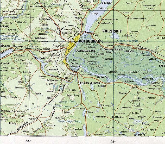
- Area map of Volgograd and the Volgograd Oblast environs of southwestern Russia.
- Includes the Volga-Don Canal
- Topographic Map NM 38, Series 1301.
- Original Scale 1:1,000,000.
- Printed by the U.S. Defense Mapping Agency Hydrographic/Topographic Center, 1979 (232K)
- from [1]
This work is in the public domain in the United States because it is a work prepared by an officer or employee of the United States Government as part of that person’s official duties under the terms of Title 17, Chapter 1, Section 105 of the US Code.
Note: This only applies to original works of the Federal Government and not to the work of any individual U.S. state, territory, commonwealth, county, municipality, or any other subdivision. This template also does not apply to postage stamp designs published by the United States Postal Service since 1978. (See § 313.6(C)(1) of Compendium of U.S. Copyright Office Practices). It also does not apply to certain US coins; see The US Mint Terms of Use.
|
 | |
| This file has been identified as being free of known restrictions under copyright law, including all related and neighboring rights. | ||
Breytingaskrá skjals
Smelltu á dagsetningu eða tímasetningu til að sjá hvernig hún leit þá út.
| Dagsetning/Tími | Smámynd | Víddir | Notandi | Athugasemd | |
|---|---|---|---|---|---|
| núverandi | 2. júlí 2005 kl. 18:27 | | 862 × 753 (218 KB) | Nikai | * Map of Volgograd, Russia ** Topographic Map NM 38, Series 1301. ** Original Scale 1:1,000,000. * Printed by the U.S. Defense Mapping Agency Hydrographic/Topographic Center, 1979 (232K) * from [http://www.lib.utexas.edu/maps/commonwealth.html] {{PD- |
Skráartenglar
Það eru engar síður sem nota þessa skrá.
Altæk notkun skráar
Eftirfarandi wikar nota einnig þessa skrá:
- Notkun á ca.wikipedia.org
- Notkun á de.wikipedia.org
- Notkun á en.wikipedia.org
- Notkun á es.wikipedia.org
- Notkun á fa.wikipedia.org
- Notkun á fr.wikipedia.org
- Notkun á mk.wikipedia.org
- Notkun á nap.wikipedia.org
- Notkun á no.wikipedia.org
- Notkun á pl.wikipedia.org
- Notkun á si.wikipedia.org
- Notkun á sl.wikipedia.org
- Notkun á tr.wikipedia.org