
Mynd:United Arab Republic (orthographic projection).svg

Stærð þessarar PNG forskoðunar á SVG skránni: 600 × 600 mynddílar. Aðrar upplausnir: 240 × 240 mynddílar | 480 × 480 mynddílar | 768 × 768 mynddílar | 1.024 × 1.024 mynddílar | 2.048 × 2.048 mynddílar | 680 × 680 mynddílar.
Upphafleg skrá (SVG-skrá, að nafni til 680 × 680 mynddílar, skráarstærð: 213 KB)
.svg)
Lýsing
| Lýsing |
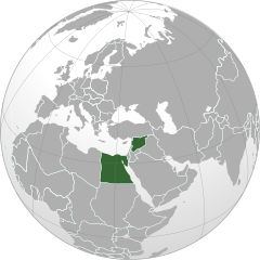
English: United Arab Republic (1958-1961)
Español: República Árabe Unida
العربية: الجمهورية العربية المتحدة |
| Dagsetning | |
| Uppruni | Own work based on: Turkey (orthographic projection).svg by The Emirr |
| Höfundarréttarhafi | L'Américain |
| SVG genesis |
.svg)
Leyfisupplýsingar:
| I, the copyright holder of this work, release this work into the public domain. This applies worldwide. In some countries this may not be legally possible; if so: I grant anyone the right to use this work for any purpose, without any conditions, unless such conditions are required by law. |
Breytingaskrá skjals
Smelltu á dagsetningu eða tímasetningu til að sjá hvernig hún leit þá út.
| Dagsetning/Tími | Smámynd | Víddir | Notandi | Athugasemd | |
|---|---|---|---|---|---|
| núverandi | 23. október 2023 kl. 18:28 | | 680 × 680 (213 KB) | M.Bitton | Reverted to version as of 00:10, 23 March 2022 (UTC): the same goes for the one that you reverted to, COM:OVERWRITE applies |
| 22. október 2023 kl. 05:36 |  | 512 × 512 (349 KB) | Bankster | Rv. The map had obvious fallencies (Tajikistan not being part of the Soviet Union) and borders are badly erased | |
| 23. mars 2022 kl. 00:10 |  | 680 × 680 (213 KB) | M.Bitton | Reverted to version as of 05:12, 3 March 2021 (UTC): changing the base map doesn't explain the map's change | |
| 14. september 2021 kl. 15:16 |  | 512 × 512 (349 KB) | Milenioscuro | limits of 1958 according to "geacron.com", base map: File:Iraq_(orthographic).svg | |
| 3. mars 2021 kl. 05:12 |  | 680 × 680 (213 KB) | Seb az86556 | Soviet Union, Czechoslovakia, Fench WA, Yugoslavia, -Eritrea, Split Germany, Split Yemen | |
| 30. janúar 2010 kl. 18:45 |  | 680 × 680 (243 KB) | L'Américain | {{Information |Description={{en|1=United Arab Republic}} {{es|1=República Árabe Unida}} {{ar|1=الجمهورية العربية المتحدة}} |Source={{own}} |Author=L'Américain |Date=30 de enero de 2010 |Permission= |other_ve |
.svg)
Skráartenglar
Eftirfarandi síða notar þessa skrá:
Altæk notkun skráar
Eftirfarandi wikar nota einnig þessa skrá:
- Notkun á ab.wikipedia.org
- Notkun á af.wikipedia.org
- Notkun á ar.wikipedia.org
- Notkun á ar.wiktionary.org
- Notkun á arz.wikipedia.org
- Notkun á ast.wikipedia.org
- Notkun á azb.wikipedia.org
- Notkun á az.wikipedia.org
- Notkun á be.wikipedia.org
- Notkun á bg.wikipedia.org
- Notkun á bn.wikipedia.org
- Notkun á br.wikipedia.org
- Notkun á bs.wikipedia.org
- Notkun á ca.wikipedia.org
- Notkun á ckb.wikipedia.org
- Notkun á da.wikipedia.org
- Notkun á de.wikipedia.org
- Notkun á el.wikipedia.org
- Notkun á en.wikipedia.org
- Notkun á es.wikipedia.org
- Notkun á et.wikipedia.org
- Notkun á eu.wikipedia.org
- Notkun á fa.wikipedia.org
- Notkun á fi.wikipedia.org
- Notkun á fr.wikipedia.org
- Notkun á gl.wikipedia.org
- Notkun á he.wikipedia.org
- Notkun á ja.wikipedia.org
- Notkun á jv.wikipedia.org
- Notkun á ka.wikipedia.org
- Notkun á ko.wikipedia.org
- Notkun á ku.wikipedia.org
- Notkun á li.wikipedia.org
- Notkun á lt.wikipedia.org
- Notkun á lv.wikipedia.org
- Notkun á mk.wikipedia.org
- Notkun á ml.wikipedia.org
- Notkun á mn.wikipedia.org
- Notkun á ms.wikipedia.org
- Notkun á pnb.wikipedia.org
- Notkun á pt.wikipedia.org
- Notkun á ro.wikipedia.org
- Notkun á ru.wikipedia.org
- Notkun á sco.wikipedia.org
- Notkun á sk.wikipedia.org
Skoða frekari altæka notkun þessarar skráar.
.svg)
.svg)