
Mynd:Timezones2008 UTC-11 gray.png

Stærð þessarar forskoðunar: 800 × 428 mynddílar Aðrar upplausnir: 320 × 171 mynddílar | 640 × 342 mynddílar | 1.024 × 548 mynddílar | 1.280 × 685 mynddílar | 3.583 × 1.917 mynddílar.
Upphafleg skrá (3.583 × 1.917 mynddílar, skráarstærð: 953 KB, MIME-gerð: image/png)
Lýsing
| Lýsing |
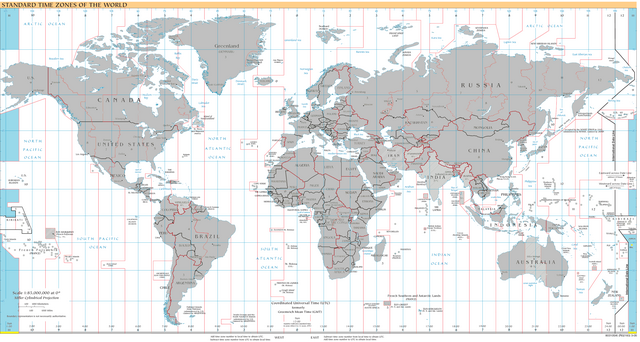
English: World map of time zones as of 2008, on the Miller Cylindrical Projection and with highlighted UTC-11 zone.
|
| Dagsetning | |
| Uppruni | Copy of Timezones2008.png. Based on the 3-05 CIA time zone map, modified to reflect the changes up to March 2010. As of July 2009, the current CIA time zone map is the 6-08 version.) |
| Höfundarréttarhafi | en:User:MrMingsz, modifications by de:User:Antonsusi. |
| Aðrar útgáfur |
 |
Leyfisupplýsingar:
| |
This work has been released into the public domain by its author, MrMingsz, at the enska Wikipedia project. This applies worldwide. In case this is not legally possible: |
Breytingaskrá skjals
Smelltu á dagsetningu eða tímasetningu til að sjá hvernig hún leit þá út.
| Dagsetning/Tími | Smámynd | Víddir | Notandi | Athugasemd | |
|---|---|---|---|---|---|
| núverandi | 12. júní 2015 kl. 21:10 | | 3.583 × 1.917 (953 KB) | Cmdrjameson | Compressed with pngout. Reduced by 655kB (40% decrease). |
| 25. september 2009 kl. 13:21 |  | 3.583 × 1.917 (1,57 MB) | Antonsusi | {{PD-user-w|en|wikipedia|MrMingsz}} Category:Maps of World time zones (grayed) |
Skráartenglar
Eftirfarandi síða notar þessa skrá:
Altæk notkun skráar
Eftirfarandi wikar nota einnig þessa skrá:
- Notkun á ar.wikipedia.org
- Notkun á az.wikipedia.org
- Notkun á ca.wikipedia.org
- Notkun á cs.wikipedia.org
- Notkun á de.wikipedia.org
- Notkun á en.wikipedia.org
- Notkun á en.wiktionary.org
- Notkun á es.wikipedia.org
- Notkun á eu.wikipedia.org
- Notkun á fr.wikipedia.org
- Notkun á id.wikipedia.org
- Notkun á ja.wikipedia.org
- Notkun á sl.wikipedia.org
- Notkun á uk.wikipedia.org
- Notkun á vec.wikipedia.org
- Notkun á vi.wikipedia.org
- Notkun á www.wikidata.org
- Notkun á zh-yue.wikipedia.org
- Notkun á zh.wikipedia.org
- Notkun á zu.wikipedia.org