
Mynd:Syrian, Iraqi, and Lebanese insurgencies.png

Upphafleg skrá (4.509 × 3.449 mynddílar, skráarstærð: 1,74 MB, MIME-gerð: image/png)
Lýsing

|
This file may be updated to reflect new information. If you wish to use a specific version of the file without new updates being mirrored, please upload the required version as a separate file. |
| Lýsing |
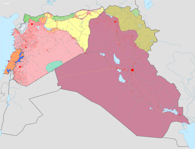
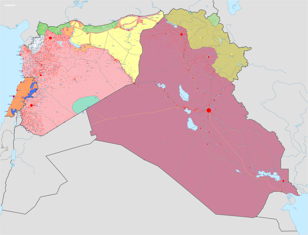
Map of the Syrian Civil War, the Iraq Civil War (2014–present), and the Lebanese insurgency. For previous revisions of the battle map (not including Lebanon) before June 2015, see File:Syria and Iraq 2014-onward War map.png. After updating this map, please also update the date(s) at w:Module:Iraq Syria map date, used to denote the date in articles. Areas under joint SDF-SAA control
In the respective colours: |
||||
| Dagsetning | |||||
| Uppruni |
eigin skrá w:en:Template:Syrian, Iraqi, and Lebanese insurgencies detailed map |
||||
| Höfundarréttarhafi | BlueHypercane761 | ||||
| Aðrar útgáfur |
|


.png)


.svg)


.svg)

.svg)


_Territory_Change_2014-2016.gif)

_(within_Northern_Syria).svg)


.png)
.svg)


_map.png)
.svg)


.svg)


|
This historical map image could be re-created using vector graphics as an SVG file. This has several advantages; see Commons:Media for cleanup for more information. If an SVG form of this image is available, please upload it and afterwards replace this template with
{{vector version available|new image name}}.
It is recommended to name the SVG file “Syrian, Iraqi, and Lebanese insurgencies.svg”—then the template Vector version available (or Vva) does not need the new image name parameter. |

|
This image has a useful history, which can be viewed as an animation. |
Leyfisupplýsingar:
- Þér er frjálst:
- að deila – að afrita, deila og yfirfæra verkið
- að blanda – að breyta verkinu
- Undir eftirfarandi skilmálum:
- tilvísun höfundarréttar – Þú verður að tilgreina viðurkenningu á höfundarréttindum, gefa upp tengil á notkunarleyfið og gefa til kynna ef breytingar hafa verið gerðar. Þú getur gert þetta á einhvern ásættanlegan máta, en ekki á nokkurn þann hátt sem bendi til þess að leyfisveitandinn styðji þig eða notkun þína á verkinu.
- Deila eins – Ef þú breytir, yfirfærir eða byggir á þessu efni, þá mátt þú eingöngu dreifa því verki með sama eða svipuðu leyfi og upprunalega verkið er með.
Breytingaskrá skjals
Smelltu á dagsetningu eða tímasetningu til að sjá hvernig hún leit þá út.
| Dagsetning/Tími | Smámynd | Víddir | Notandi | Athugasemd | |
|---|---|---|---|---|---|
| núverandi | 6. september 2020 kl. 11:43 | | 4.509 × 3.449 (1,74 MB) | LyriaSiders | Reports that the SAA have taken over the Doubayat oil and gas field and surrounding area from ISIL elements. Now there is apparently no more hard control by ISIL in the central desert. |
| 24. maí 2020 kl. 15:10 |  | 4.509 × 3.449 (2,21 MB) | Wiz9999 | Updating Revolutionary Commando Army & US presence colour to teal. | |
| 7. mars 2020 kl. 11:27 |  | 4.509 × 3.449 (1,74 MB) | Nate Hooper | Update after the Turkish response. Also, see the discussion page for a further update I have planned. | |
| 19. febrúar 2020 kl. 03:23 |  | 4.509 × 3.449 (1,75 MB) | Nate Hooper | Update after the Idlib offensive. | |
| 7. febrúar 2020 kl. 23:45 |  | 4.509 × 3.449 (1,75 MB) | The Dolly Parton Challenge - Still more country than Alan Jackson | Further SAA advances towards Idlib. | |
| 7. febrúar 2020 kl. 23:26 |  | 4.509 × 3.449 (2,51 MB) | The Dolly Parton Challenge - Still more country than Alan Jackson | Reverted to version as of 00:25, 6 February 2020 (UTC) Never mind | |
| 6. febrúar 2020 kl. 00:32 |  | 4.509 × 3.449 (2,51 MB) | TheHatingNerdino666 | Fixed the Manbij area. | |
| 6. febrúar 2020 kl. 00:25 |  | 4.509 × 3.449 (2,51 MB) | TheHatingNerdino666 | Big update as the Syrian Army continues the push towards Idlib. | |
| 7. janúar 2020 kl. 17:05 |  | 4.509 × 3.449 (2,27 MB) | Nate Hooper | Wew, it's been a while (I was a way for a bit because I was banned, but I appealed and was successful). Anyway, the SAA have made advances in Idlib. | |
| 27. október 2019 kl. 17:05 |  | 4.509 × 3.449 (2,51 MB) | Mlpwtfisthat Backup 7.0 | Remove the date. |
Skráartenglar
Það eru engar síður sem nota þessa skrá.
Altæk notkun skráar
Eftirfarandi wikar nota einnig þessa skrá:
- Notkun á ar.wikipedia.org
- Notkun á arz.wikipedia.org
- Notkun á de.wikipedia.org
- Notkun á en.wikipedia.org
- Template talk:Lebanese insurgency detailed map
- Module talk:Syrian, Iraqi, and Lebanese insurgencies detailed map
- Module talk:Syrian and Iraqi insurgency detailed map/Archive 1
- Module talk:Iraqi insurgency detailed map/Archive 4
- Talk:Control of cities during the Syrian civil war/Archive 49
- User:AH bharara/sandbox/Islamic State of Iraq and the Levant affiliated Groups
- Talk:Islamic State/Archive 38
- Wikipedia:Graphics Lab/Map workshop/Archive/2016
- Talk:Islamic State/Archive 40
- Talk:Battle of Mosul (2016–2017)/Archive 1
- Talk:Islamic State/Archive 41
- User:KaldeFakta68/sandbox
- User:Edisonabcd/sandbox
- Notkun á fa.wikipedia.org
- Notkun á fr.wikipedia.org
- Notkun á id.wikipedia.org
- Notkun á ku.wikipedia.org
- Notkun á mi.wikipedia.org
- Notkun á pt.wikinews.org
- Notkun á tr.wikipedia.org
- Notkun á www.wikidata.org
- Notkun á zh.wikipedia.org