
Mynd:Sorex palustris distribution.svg

Stærð þessarar PNG forskoðunar á SVG skránni: 515 × 599 mynddílar. Aðrar upplausnir: 206 × 240 mynddílar | 412 × 480 mynddílar | 660 × 768 mynddílar | 880 × 1.024 mynddílar | 1.760 × 2.048 mynddílar | 1.712 × 1.992 mynddílar.
Upphafleg skrá (SVG-skrá, að nafni til 1.712 × 1.992 mynddílar, skráarstærð: 240 KB)
| Lýsing |
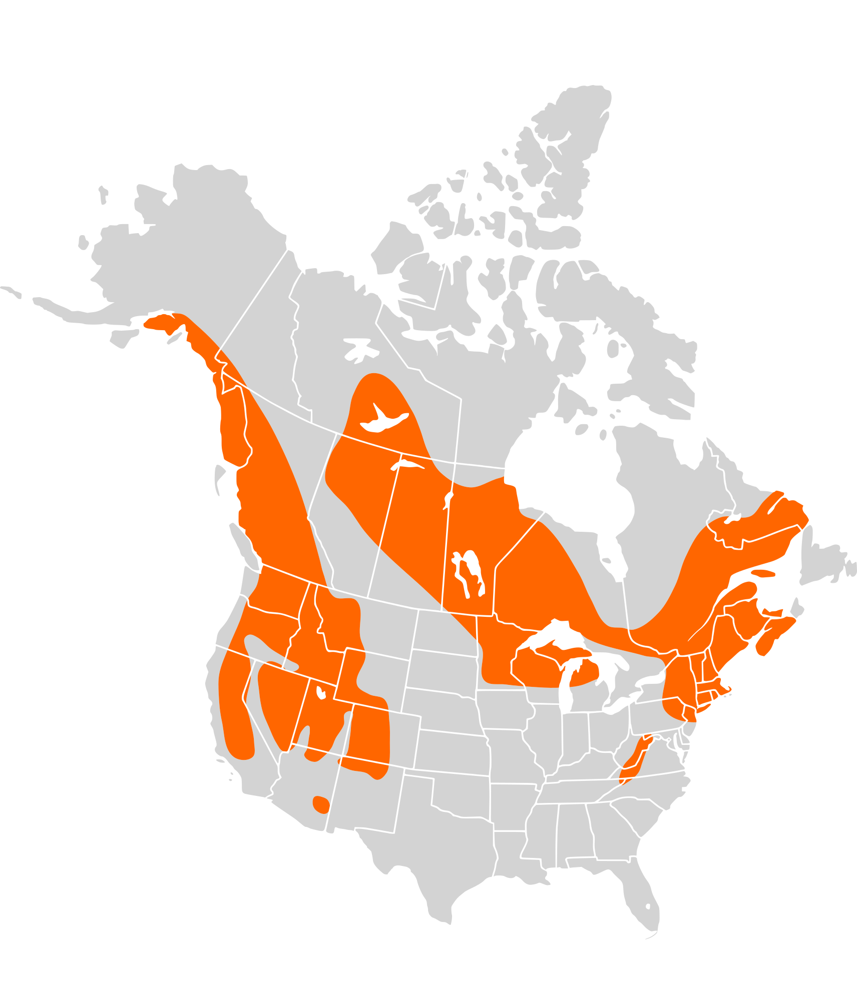
English: Distribution of the American Water Shrew (Sorex palustris) with http://www.mnh.si.edu/mna/thumbnails/maps/322.gif
Français : Distribution de la Musaraigne palustre (Sorex palustris) à partir de http://www.mnh.si.edu/mna/thumbnails/maps/322.gif
W3C-validity not checked. |
| Dagsetning | (UTC) |
| Uppruni | |
| Höfundarréttarhafi |
|
| This is a retouched picture, which means that it has been digitally altered from its original version. The original can be viewed here: North America second level political division 2.svg:
|
I, the copyright holder of this work, hereby publish it under the following license:
This file is licensed under the Creative Commons Attribution-Share Alike 2.5 Generic license.
- Þér er frjálst:
- að deila – að afrita, deila og yfirfæra verkið
- að blanda – að breyta verkinu
- Undir eftirfarandi skilmálum:
- tilvísun höfundarréttar – Þú verður að tilgreina viðurkenningu á höfundarréttindum, gefa upp tengil á notkunarleyfið og gefa til kynna ef breytingar hafa verið gerðar. Þú getur gert þetta á einhvern ásættanlegan máta, en ekki á nokkurn þann hátt sem bendi til þess að leyfisveitandinn styðji þig eða notkun þína á verkinu.
- Deila eins – Ef þú breytir, yfirfærir eða byggir á þessu efni, þá mátt þú eingöngu dreifa því verki með sama eða svipuðu leyfi og upprunalega verkið er með.
Original upload log
This image is a derivative work of the following images:
- File:North_America_second_level_political_division_2.svg licensed with Cc-by-sa-2.5
- 2007-12-08T23:23:36Z Lokal Profil 1712x1992 (335351 Bytes) Code cleanup
- 2007-10-07T07:55:13Z AlexCovarrubias 1712x1992 (350437 Bytes) == Summary == {{Information |Description=Map of North America and its second-level political divisions. Canadian provinces, US and Mexican states. Canada, Mexico, United States. |Source=Canada and US map by Alan Rockefeller.
Uploaded with derivativeFX
Breytingaskrá skjals
Smelltu á dagsetningu eða tímasetningu til að sjá hvernig hún leit þá út.
| Dagsetning/Tími | Smámynd | Víddir | Notandi | Athugasemd | |
|---|---|---|---|---|---|
| núverandi | 31. janúar 2010 kl. 17:08 | | 1.712 × 1.992 (240 KB) | Totodu74 | {{Information |Description={{en|Map of North America and its second-level political divisions. Canadian provinces, US and Mexican states. Canada, Mexico, United States. Non-contiguous parts of a states/provinces are "grouped" together with the main area |
Skráartenglar
Eftirfarandi síða notar þessa skrá:
Altæk notkun skráar
Eftirfarandi wikar nota einnig þessa skrá:
- Notkun á ar.wikipedia.org
- Notkun á avk.wikipedia.org
- Notkun á ceb.wikipedia.org
- Notkun á de.wikipedia.org
- Notkun á en.wikipedia.org
- Notkun á fr.wikipedia.org
- Notkun á he.wikipedia.org
- Notkun á nl.wikipedia.org
- Notkun á nv.wikipedia.org
- Notkun á pt.wikipedia.org
- Notkun á ru.wikipedia.org
- Notkun á simple.wikipedia.org
- Notkun á sv.wikipedia.org
- Notkun á uk.wikipedia.org
- Notkun á vi.wikipedia.org