
Mynd:Mid-atlantic ridge map.png
Það er engin hærri upplausn til.
Mid-atlantic_ridge_map.png (200 × 415 mynddílar, skráarstærð: 21 KB, MIME-gerð: image/png)
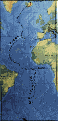
| Lýsing | small image showing the location of the Mid-Atlantic ridge |
| Uppruni | [1] |
| Höfundarréttarhafi | originally uploaded on the English wikipedia: 14:51, 21 October 2003 . . JamesDay (Talk / contribs) . . 200×415 (21,177 bytes) (mid-Atlantic ridge map) |
| Réttindi (Endurnotkun á þessari skrá) |
Copyright: public domain. US Geological Survey image. Copyright statement: [2] "Information presented on this website is considered public information and may be distributed or copied. Use of appropriate byline/photo/image credit is requested." |
This image is in the public domain in the United States because it only contains materials that originally came from the United States Geological Survey, an agency of the United States Department of the Interior. For more information, see the official USGS copyright policy.
|
Breytingaskrá skjals
Smelltu á dagsetningu eða tímasetningu til að sjá hvernig hún leit þá út.
| Dagsetning/Tími | Smámynd | Víddir | Notandi | Athugasemd | |
|---|---|---|---|---|---|
| núverandi | 1. febrúar 2007 kl. 11:02 | | 200 × 415 (21 KB) | Woudloper | {{Information |Description=small image showing the location of the Mid-Atlantic ridge |Source=[http://pubs.usgs.gov/publications/text/ridge.html] |Date= |Author=originally uploaded on the English wikipedia: 14:51, 21 October 2003 . . JamesDay (Talk | cont |
Skráartenglar
Eftirfarandi síða notar þessa skrá:
Altæk notkun skráar
Eftirfarandi wikar nota einnig þessa skrá:
- Notkun á ar.wikipedia.org
- Notkun á ast.wikipedia.org
- Notkun á bg.wikipedia.org
- Notkun á ce.wikipedia.org
- Notkun á da.wikipedia.org
- Notkun á en.wikipedia.org
- Notkun á en.wikibooks.org
- Notkun á es.wikipedia.org
- Notkun á fa.wikipedia.org
- Notkun á fi.wikipedia.org
- Notkun á gl.wikipedia.org
- Notkun á hu.wikipedia.org
- Notkun á ka.wikipedia.org
- Notkun á ko.wikipedia.org
- Notkun á lt.wikipedia.org
- Notkun á mk.wikipedia.org
- Notkun á ml.wikipedia.org
- Notkun á ms.wikipedia.org
- Notkun á nl.wikipedia.org
- Notkun á no.wikipedia.org
- Notkun á pt.wikipedia.org
- Notkun á ro.wikipedia.org
- Notkun á ru.wikinews.org
- Notkun á simple.wikipedia.org
- Notkun á sl.wikipedia.org
- Notkun á sr.wikipedia.org
- Notkun á sw.wikipedia.org
- Notkun á tr.wikipedia.org
- Notkun á uk.wikipedia.org
- Notkun á vi.wikipedia.org
- Notkun á zh-yue.wikipedia.org
- Notkun á zh.wikipedia.org