
Mynd:Marcellinus Dalmatia.jpg

Stærð þessarar forskoðunar: 607 × 600 mynddílar Aðrar upplausnir: 243 × 240 mynddílar | 486 × 480 mynddílar | 778 × 768 mynddílar | 1.054 × 1.041 mynddílar.
Upphafleg skrá (1.054 × 1.041 mynddílar, skráarstærð: 98 KB, MIME-gerð: image/jpeg)
Lýsing
| Lýsing |
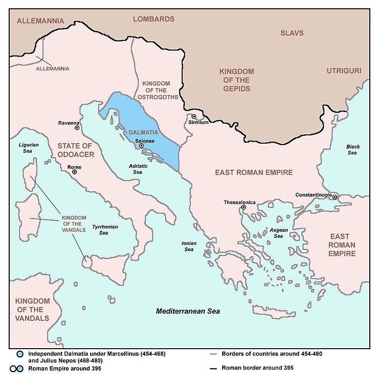
English: Independent Dalmatia - Extent of Marcellinus' Control (454-468) and Julius Nepos' Control (468-480). Srpskohrvatski / српскохрватски: Nezavisna Dalmacija - Područje pod kontrolom Marcelina (454-468) i Julija Nepota (468-480). |
| Dagsetning | 18. febrúar 2007 (original upload date) |
| Uppruni | Map is based on this one made by User:PANONIAN: http://en.wikipedia.org/wiki/Image:Prefecture.png |
| Höfundarréttarhafi | Neos Dionysos at enska Wikipedia |
| Aðrar útgáfur |
|

Leyfisupplýsingar:
| This work has been released into the public domain by its author, Neos Dionysos at enska Wikipedia. This applies worldwide. In some countries this may not be legally possible; if so: Neos Dionysos grants anyone the right to use this work for any purpose, without any conditions, unless such conditions are required by law. |
References
Primary source:
- Based on this source: Dragan Brujić, Vodič kroz svet Vizantije, Beograd, 2004. (Online version: [1] archive copy at the Wayback Machine, pages 11 and 13)
Secondary sources:
- http://pages.uoregon.edu/mapplace/EU/EU19%20-%20Italy/Maps/EU19_07.jpg
- http://www.emersonkent.com/images/europe_476.jpg
- http://recklessbooks.co.uk/communities/9/004/007/811/829/images/4535699992_525x369.jpg
- http://recklessbooks.co.uk/#/34-puppet-emperors/4542500399
- http://i251.photobucket.com/albums/gg311/beebybooks/Spruner/IMG_4017.jpg (Note: image from Photobucket used only as a secondary reference)
- http://4.bp.blogspot.com/-yRv7usvddEI/TogNM7bUU5I/AAAAAAAAChA/0XBMB4dQyzA/s1600/europeantribes5thC.jpg
- http://waucondastore.com/wp-content/uploads/2012/10/The-Germanic-invasions-410-1066.jpg
- http://www.heritage-history.com/maps/philips/phil002.jpg
- http://rbedrosian.com/Maps/muhamm6a.jpg
- http://www.miklianmaps.com/images/1876%20Norstedt%2008%20europe%20476.jpg
- http://www.historyandcivilization.com/Peoples___Kingdoms_in_the_West_c_476AD.jpg
- http://0.tqn.com/d/historymedren/1/0/G/N/2/ms476europe.jpg
- http://fc06.deviantart.net/fs71/i/2013/132/2/9/the_end_of_the_western_roman_empire__ad_476__by_undevicesimus-d5tem60.jpg
- http://upload.wikimedia.org/wikipedia/commons/thumb/b/b5/Vandali.jpg/744px-Vandali.jpg
- http://www.enciklopedija.hr/Ilustracije/Dalmacija_u_doba_rimljana.jpg
Original upload log
Transferred from en.wikipedia to Commons by BokicaK using CommonsHelper.
The original description page was here. All following user names refer to en.wikipedia.
- 2007-02-18 21:34 Neos Dionysos 1054×1041× (126215 bytes) Extent of Marcellinus' Control. I found this picture on another wiki page which was made from scratch and so I edited it to fit the needs I for this article.
Breytingaskrá skjals
Smelltu á dagsetningu eða tímasetningu til að sjá hvernig hún leit þá út.
| Dagsetning/Tími | Smámynd | Víddir | Notandi | Athugasemd | |
|---|---|---|---|---|---|
| núverandi | 27. júní 2013 kl. 23:38 | | 1.054 × 1.041 (98 KB) | PANONIAN | addition |
| 27. júní 2013 kl. 23:01 |  | 1.054 × 1.041 (96 KB) | PANONIAN | fixed year | |
| 27. júní 2013 kl. 22:35 |  | 1.054 × 1.041 (96 KB) | PANONIAN | improved version, borders of Dalmatia based on this source: Dragan Brujić, Vodič kroz svet Vizantije, Beograd, 2004. | |
| 7. mars 2013 kl. 05:30 |  | 1.054 × 1.041 (123 KB) | File Upload Bot (Magnus Manske) | Transfered from en.wikipedia by User:BokicaK using CommonsHelper |
Skráartenglar
Eftirfarandi síða notar þessa skrá:
Altæk notkun skráar
Eftirfarandi wikar nota einnig þessa skrá:
- Notkun á ar.wikipedia.org
- Notkun á azb.wikipedia.org
- Notkun á bg.wikipedia.org
- Notkun á bs.wikipedia.org
- Notkun á ca.wikipedia.org
- Notkun á cs.wikipedia.org
- Notkun á da.wikipedia.org
- Notkun á de.wikipedia.org
- Notkun á el.wikipedia.org
- Notkun á en.wikipedia.org
- Notkun á es.wikipedia.org
- Notkun á fr.wikipedia.org
- Notkun á gl.wikipedia.org
- Notkun á hr.wikipedia.org
- Notkun á hy.wikipedia.org
- Notkun á it.wikipedia.org
- Notkun á nl.wikipedia.org
- Notkun á no.wikipedia.org
- Notkun á ru.wikipedia.org
- Notkun á sh.wikipedia.org
- Notkun á sq.wikipedia.org
- Notkun á sr.wikipedia.org
- Notkun á sv.wikipedia.org
- Notkun á tr.wikipedia.org
- Notkun á www.wikidata.org
- Notkun á zh.wikipedia.org