
Mynd:Map of the Welland Canal.png

Stærð þessarar forskoðunar: 665 × 599 mynddílar Aðrar upplausnir: 266 × 240 mynddílar | 533 × 480 mynddílar | 852 × 768 mynddílar | 1.174 × 1.058 mynddílar.
Upphafleg skrá (1.174 × 1.058 mynddílar, skráarstærð: 104 KB, MIME-gerð: image/png)
Lýsing
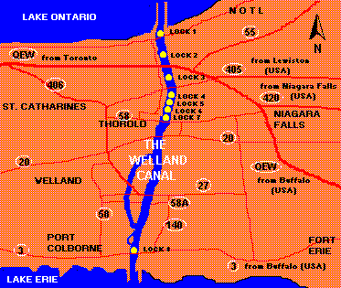
| Lýsing | Map of the Welland Canal |
| Dagsetning | |
| Uppruni | eigin skrá |
| Höfundarréttarhafi | Agyle |
Done in photoshop, used http://www.wellandcanal.com/map.gif for lock numbering, traced google maps for shoreline.
Leyfisupplýsingar:
| This work has been released into the public domain by its author, I, Agyle. This applies worldwide. In some countries this may not be legally possible; if so: I, Agyle grants anyone the right to use this work for any purpose, without any conditions, unless such conditions are required by law. |
Breytingaskrá skjals
Smelltu á dagsetningu eða tímasetningu til að sjá hvernig hún leit þá út.
| Dagsetning/Tími | Smámynd | Víddir | Notandi | Athugasemd | |
|---|---|---|---|---|---|
| núverandi | 4. ágúst 2007 kl. 06:23 | | 1.174 × 1.058 (104 KB) | Agyle | {{Information |Description=Map of the Welland Canal |Source=self-made |Date=2007-08-04 |Author= Agyle }} Done in photoshop, used http://www.wellandcanal.com/map.gif for lock numbering, traced google maps for shoreline. |
Skráartenglar
Eftirfarandi síða notar þessa skrá:
Altæk notkun skráar
Eftirfarandi wikar nota einnig þessa skrá:
- Notkun á ar.wikipedia.org
- Notkun á arz.wikipedia.org
- Notkun á cs.wikipedia.org
- Notkun á en.wikipedia.org
- Notkun á en.wikivoyage.org
- Notkun á eo.wikipedia.org
- Notkun á es.wikipedia.org
- Notkun á fr.wikipedia.org
- Notkun á he.wikipedia.org
- Notkun á hu.wikipedia.org
- Notkun á hy.wikipedia.org
- Notkun á it.wikipedia.org
- Notkun á ja.wikipedia.org
- Notkun á nl.wikipedia.org
- Notkun á ru.wikipedia.org
- Notkun á tr.wikipedia.org
- Notkun á uk.wikipedia.org
- Notkun á www.wikidata.org
- Notkun á zh.wikipedia.org