
Mynd:Liechtenstein - Location Map (2013) - LIE - UNOCHA.svg

Upphafleg skrá (SVG-skrá, að nafni til 250 × 250 mynddílar, skráarstærð: 952 KB)
_-_LIE_-_UNOCHA.svg)
Lýsing
| Lýsing |
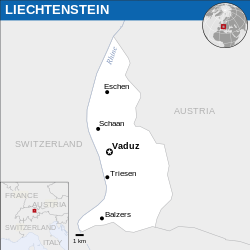
English: Locator map of Liechtenstein. |
| Dagsetning | |
| Uppruni |
English: Liechtenstein Locator Map (ReliefWeb), ESRI, UNCS |
| Höfundarréttarhafi | |
| SVG genesis |
Leyfisupplýsingar:
- Þér er frjálst:
- að deila – að afrita, deila og yfirfæra verkið
- að blanda – að breyta verkinu
- Undir eftirfarandi skilmálum:
- tilvísun höfundarréttar – Þú verður að tilgreina viðurkenningu á höfundarréttindum, gefa upp tengil á notkunarleyfið og gefa til kynna ef breytingar hafa verið gerðar. Þú getur gert þetta á einhvern ásættanlegan máta, en ekki á nokkurn þann hátt sem bendi til þess að leyfisveitandinn styðji þig eða notkun þína á verkinu.
 This map is part of a collection of 216 free country maps, created by the UN Office for the Coordination of Humanitarian Affairs (OCHA), to be used in print, web or broadcast products.
The ReliefWeb Location Maps released here are maps that highlight a country, its capital, major populated places and the surrounding regions. Attribution Requirements
Using the map without modifications: ensure that the sources and the disclaimer are below the map. Credit as follows: "Credit: OCHA". For use with alteration: remove the OCHA logo and disclaimer following any modification to the map, but keep the data sources as mentioned below the map. Credit the modified map as follows: "Based on OCHA map". You are responsible for the content of your map. We are keen to receive your feedback and hear how you used OCHA's maps. We would be grateful if you would notify us by e-mail and share your work with us. UN Disclaimer
The designations employed and the presentation of material of this map do not imply the expression of any opinion whatsoever on the part of the Secretariat of the United Nations concerning the legal status of any country, territory, city or area or of its authorities or concerning the delimitation of its frontiers or boundaries. |

|
Textual information (e.g. timestamp) once visible in the image itself has been moved into the image metadata and/or image description page. This makes the image easier to reuse and more language-neutral, and makes the text easier to process and search for. Commons discourages placing visible textual information in images. All licenses accepted on Commons permit this type of modification as a derivative work.
If attribution information were removed and the image is not public domain, replace this tag with {{Attribution metadata from licensed image}}.
|
Breytingaskrá skjals
Smelltu á dagsetningu eða tímasetningu til að sjá hvernig hún leit þá út.
| Dagsetning/Tími | Smámynd | Víddir | Notandi | Athugasemd | |
|---|---|---|---|---|---|
| núverandi | 5. febrúar 2024 kl. 15:53 | | 250 × 250 (952 KB) | Illchy | File uploaded using svgtranslate tool (https://svgtranslate.toolforge.org/). Added translation for id. |
| 9. apríl 2023 kl. 07:57 |  | 250 × 250 (951 KB) | Darafsh | File uploaded using svgtranslate tool (https://svgtranslate.toolforge.org/). Added translation for fa. | |
| 25. mars 2016 kl. 13:29 |  | 250 × 250 (948 KB) | Wereldburger758 | Resized page to drawing. Removal watermark. Validation of image. | |
| 21. apríl 2014 kl. 04:29 |  | 254 × 254 (931 KB) | UN OCHA maps bot | == {{int:filedesc}} == {{Information |description={{en|1=Locator map of Liechtenstein.}} |date=2013 |source={{en|1=[http://reliefweb.int/map/liechtenstein/liechtenstein-location-map-2013 Liechtenstein Locator Map (ReliefWeb)]}} |... |
Skráartenglar
Það eru engar síður sem nota þessa skrá.
Altæk notkun skráar
Eftirfarandi wikar nota einnig þessa skrá:
- Notkun á azb.wikipedia.org
- Notkun á bh.wikipedia.org
- Notkun á ckb.wikipedia.org
- Notkun á en.wikipedia.org
- Notkun á fa.wikipedia.org
- Notkun á id.wikipedia.org
- Notkun á io.wikipedia.org
- Notkun á ka.wikipedia.org
- Notkun á km.wikipedia.org
- Notkun á mn.wikipedia.org
- Notkun á ne.wikipedia.org
- Notkun á pl.wikipedia.org
- Notkun á sco.wikipedia.org
- Notkun á sd.wikipedia.org
- Notkun á shn.wikipedia.org
- Notkun á th.wikipedia.org
- Notkun á to.wikipedia.org
- Notkun á zh-yue.wikipedia.org
_-_LIE_-_UNOCHA.svg)