
Mynd:Globe panorama03.jpg

Stærð þessarar forskoðunar: 800 × 533 mynddílar Aðrar upplausnir: 320 × 213 mynddílar | 640 × 427 mynddílar | 1.024 × 683 mynddílar | 1.280 × 853 mynddílar | 2.560 × 1.707 mynddílar | 3.750 × 2.500 mynddílar.
Upphafleg skrá (3.750 × 2.500 mynddílar, skráarstærð: 2,75 MB, MIME-gerð: image/jpeg)
|
Lýsing
| Lýsing |
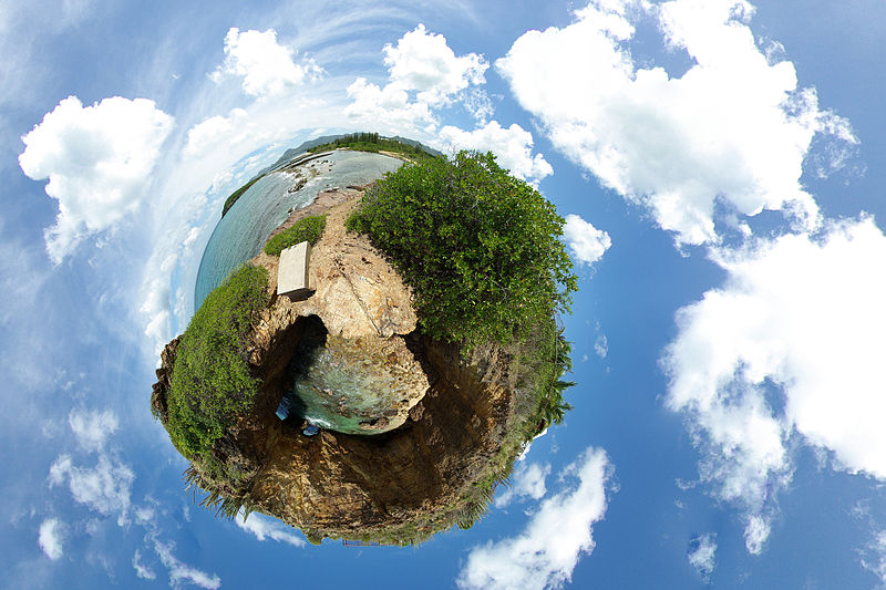
English: A 360-degree spherical panorama of a beach in Marigot, Saint Martin, from 9 images which uses stereographic projection to create a globe. This is called the "little planet" effect, when the area close to the point opposite to the center of projection becomes significantly enlarged. A detailed explanation of how it is done can be found here. This place is named Devil's Hole, located on the Low-lands area of the Saint Martin island (FWI) |
| Dagsetning | |
| Uppruni | Le trou de David |
| Höfundarréttarhafi | Alexandre Duret-Lutz from Paris, France |
| Aðrar útgáfur |
Derivative works of this file: Globe panorama03 (cropped).jpg |

.jpg)
| Camera location | | View this and other nearby images on: OpenStreetMap |
|---|
| 360° | View in 360° panoramic viewer
|
|---|
Leyfisupplýsingar:
This file is licensed under the Creative Commons Attribution-Share Alike 2.0 Generic license.
- Þér er frjálst:
- að deila – að afrita, deila og yfirfæra verkið
- að blanda – að breyta verkinu
- Undir eftirfarandi skilmálum:
- tilvísun höfundarréttar – Þú verður að tilgreina viðurkenningu á höfundarréttindum, gefa upp tengil á notkunarleyfið og gefa til kynna ef breytingar hafa verið gerðar. Þú getur gert þetta á einhvern ásættanlegan máta, en ekki á nokkurn þann hátt sem bendi til þess að leyfisveitandinn styðji þig eða notkun þína á verkinu.
- Deila eins – Ef þú breytir, yfirfærir eða byggir á þessu efni, þá mátt þú eingöngu dreifa því verki með sama eða svipuðu leyfi og upprunalega verkið er með.
| This image, originally posted to Flickr, was reviewed on 31 December 2007 by the administrator or reviewer RedCoat, who confirmed that it was available on Flickr under the stated license on that date. |
Breytingaskrá skjals
Smelltu á dagsetningu eða tímasetningu til að sjá hvernig hún leit þá út.
| Dagsetning/Tími | Smámynd | Víddir | Notandi | Athugasemd | |
|---|---|---|---|---|---|
| núverandi | 17. nóvember 2013 kl. 11:21 | | 3.750 × 2.500 (2,75 MB) | Denniss | Reverted to version as of 19:21, 31 December 2007 |
| 31. desember 2007 kl. 19:21 |  | 3.750 × 2.500 (2,75 MB) | File Upload Bot (Magnus Manske) | {{BotMoveToCommons|en.wikipedia}} {{Information |Description={{en|A 360 degree panorama projected into a spherical shape. Uploaded to [http://flickr.com/photo_zoom.gne?id=1188430515&context=set-72157594279945875&size=l flickr] by gadl. A detailed explant |
Skráartenglar
Eftirfarandi síða notar þessa skrá:
Altæk notkun skráar
Eftirfarandi wikar nota einnig þessa skrá:
- Notkun á ar.wikipedia.org
- Notkun á ast.wikipedia.org
- Notkun á ca.wikipedia.org
- Notkun á cs.wikipedia.org
- Notkun á de.wikipedia.org
- Notkun á el.wikipedia.org
- Notkun á en.wikipedia.org
- User talk:Abdominator
- User:Chutzpan
- User:Goa103~enwiki
- User:Virek
- Wikipedia:Featured pictures thumbs/09
- Wikipedia:April Fools' Main Page/Today's Featured Picture/Archive 2008
- Wikipedia:Featured picture candidates/January-2008
- Wikipedia:Featured picture candidates/Stereographic panorama
- Wikipedia:Wikipedia Signpost/2008-01-02/Features and admins
- Wikipedia:April Fools' Main Page/Today's Featured Picture/Archive 2009
- Wikipedia:Picture of the day/May 2008
- Template:POTD/2008-05-13
- Wikipedia:Reference desk/Archives/Science/2008 May 8
- Wikipedia:Wikipedia Signpost/2009-01-24/Dispatches
- Wikipedia talk:Wikipedia Signpost/2009-01-24/Dispatches
- Wikipedia:Featured pictures/Photographic techniques, terms, and equipment
- Portal:The arts/Recognized content
- Wikipedia:Wikipedia Signpost/Single/2008-01-02
- Notkun á es.wikipedia.org
- Super Mario Galaxy
- Wikipedia:Recurso del día/abril de 2008
- Wikipedia:Imágenes destacadas/Ciencias
- Wikipedia:Candidatos a recursos destacados/Globe panorama03.jpg
- Plantilla:RDD/118
- Wikipedia:Recurso del día/101 - 200
- Wikipedia:Recurso del día/febrero de 2009
- Wikipedia:Recurso del día/abril de 2010
- Usuario:SAVE THE World/Trabajos y contribuciones
- Wikipedia:Recurso del día/octubre de 2011
- Wikipedia:Recurso del día/octubre de 2013
- Portal:Biología/Imágenes/Archivo
- Portal:Biología/Imagen/Aleatorio/4
- Wikipedia:Recurso del día/abril de 2016
- Wikipedia:Recurso del día/julio de 2018
- Wikipedia:Recurso del día/noviembre de 2020
- Wikipedia:Recurso del día/octubre de 2023
- Notkun á fr.wikipedia.org
- Notkun á fr.wikibooks.org
- Notkun á id.wikipedia.org
- Notkun á ja.wikipedia.org
- Notkun á la.wikipedia.org
- Notkun á ml.wikipedia.org
Skoða frekari altæka notkun þessarar skráar.