
Mynd:Gibraltar map-en-edit2.svg

Stærð þessarar PNG forskoðunar á SVG skránni: 385 × 600 mynddílar. Aðrar upplausnir: 154 × 240 mynddílar | 308 × 480 mynddílar | 493 × 768 mynddílar | 657 × 1.024 mynddílar | 1.314 × 2.048 mynddílar | 1.000 × 1.558 mynddílar.
Upphafleg skrá (SVG-skrá, að nafni til 1.000 × 1.558 mynddílar, skráarstærð: 1,46 MB)
Lýsing
|
This W3C-unspecified vector image was created with Inkscape .
| Camera location | | View this and other nearby images on: OpenStreetMap |
|---|
| Lýsing |
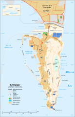
English: Map in English of Gibraltar
Français : Carte en anglais de Gibraltar |
| Dagsetning | |
| Uppruni |
English: adapted from: Image:Gibraltar map-en.svg
Français : Création personnelle ;
|
| Höfundarréttarhafi | Original by Eric Gaba (Sting), label/legend edits by Jeff Dahl |
| Réttindi (Endurnotkun á þessari skrá) |
Attribution and Share-Alike required |
| Aðrar útgáfur |
|


|
This SVG file contains embedded text that can be translated into your language, using any capable SVG editor, text editor or the SVG Translate tool. For more information see: About translating SVG files. |
Leyfisupplýsingar:
I, the copyright holder of this work, hereby publish it under the following licenses:

|
Gefið er leyfi til að afrita, dreifa og/eða breyta þessu skjali samkvæmt Frjálsa GNU Free Documentation License, útgáfu 1.2 eða nýrri, sem gefið er út af Frjálsu hugbúnaðarstofnuninni með engum breytingum þar á. Afrit af leyfinu er innifalið í kaflanum GNU Free Documentation License. |
This file is licensed under the Creative Commons Attribution-Share Alike 4.0 International, 3.0 Unported, 2.5 Generic, 2.0 Generic and 1.0 Generic license.
- Þér er frjálst:
- að deila – að afrita, deila og yfirfæra verkið
- að blanda – að breyta verkinu
- Undir eftirfarandi skilmálum:
- tilvísun höfundarréttar – Þú verður að tilgreina viðurkenningu á höfundarréttindum, gefa upp tengil á notkunarleyfið og gefa til kynna ef breytingar hafa verið gerðar. Þú getur gert þetta á einhvern ásættanlegan máta, en ekki á nokkurn þann hátt sem bendi til þess að leyfisveitandinn styðji þig eða notkun þína á verkinu.
- Deila eins – Ef þú breytir, yfirfærir eða byggir á þessu efni, þá mátt þú eingöngu dreifa því verki með sama eða svipuðu leyfi og upprunalega verkið er með.
Þú mátt velja notkunarleyfi að eigin vali.
Breytingaskrá skjals
Smelltu á dagsetningu eða tímasetningu til að sjá hvernig hún leit þá út.
| Dagsetning/Tími | Smámynd | Víddir | Notandi | Athugasemd | |
|---|---|---|---|---|---|
| núverandi | 5. apríl 2017 kl. 16:36 | | 1.000 × 1.558 (1,46 MB) | RaviC | + University, Ferry terminal (& Route), Cathedral |
| 11. desember 2007 kl. 18:52 |  | 1.000 × 1.558 (1,79 MB) | Jeff Dahl | resized 1200 down to 1000px wide, minor label fixes | |
| 10. desember 2007 kl. 17:08 |  | 1.200 × 1.870 (1,78 MB) | Jeff Dahl | {{inkscape}} {{Location|36|08|00|N|5|21|00|W|type:city_scale:50000}} {{Information |Description=Map in English of Gibraltar |Source=adapted from: Image:Gibraltar map-en.svg <br/>Map created using screenshots of [[:en:Google Ea |
Skráartenglar
Eftirfarandi síða notar þessa skrá:
Altæk notkun skráar
Eftirfarandi wikar nota einnig þessa skrá:
- Notkun á af.wikipedia.org
- Notkun á ar.wikipedia.org
- Notkun á av.wikipedia.org
- Notkun á azb.wikipedia.org
- Notkun á bg.wikipedia.org
- Notkun á bn.wikipedia.org
- Notkun á bs.wikipedia.org
- Notkun á ceb.wikipedia.org
- Plantilya:Location map Gibraltar
- Signal Hill
- White Rock
- Sandy Bay
- Roca Blanca
- Ailsa Craig
- Passage Point
- El Peñón
- The Rock
- Middle Hill
- Gibraltar (pagklaro)
- Rock of Gibraltar
- Deadmans Beach
- Eastern Beach
- Western Beach
- Punta Pasaje
- Punta Europa
- La Roca
- Governor’s Beach
- Camp Bay
- Europa Point
- Gibraltar Bay
- Cerro de Enmedio
- Blackstrap Bay
- Caledonian Canal
- Great Europa Point
- Gibilterra
- White Rock (bato sa Gyibraltar)
- Western Beach (lapyahan sa Gyibraltar)
- Signal Hill (bungtod sa Gyibraltar)
- Sandy Bay North
- Sandy Bay (luuk)
- Saint Michael's Cave
- Saint Abb's Head
- North Gorge
- Middle Hill (bungtod sa Gyibraltar)
- Mediterranean Steps
- Martin's Cave
- Europa Point (punta sa Gyibraltar)
- The Lido
- Levant Cave
- H.M.S. Rooke
Skoða frekari altæka notkun þessarar skráar.