
Mynd:FraMauroDetailedMapInverted.jpg
Stærð þessarar forskoðunar: 602 × 599 mynddílar Aðrar upplausnir: 241 × 240 mynddílar | 482 × 480 mynddílar | 771 × 768 mynddílar | 1.029 × 1.024 mynddílar | 2.255 × 2.245 mynddílar.
Upphafleg skrá (2.255 × 2.245 mynddílar, skráarstærð: 6,48 MB, MIME-gerð: image/jpeg)
Lýsing
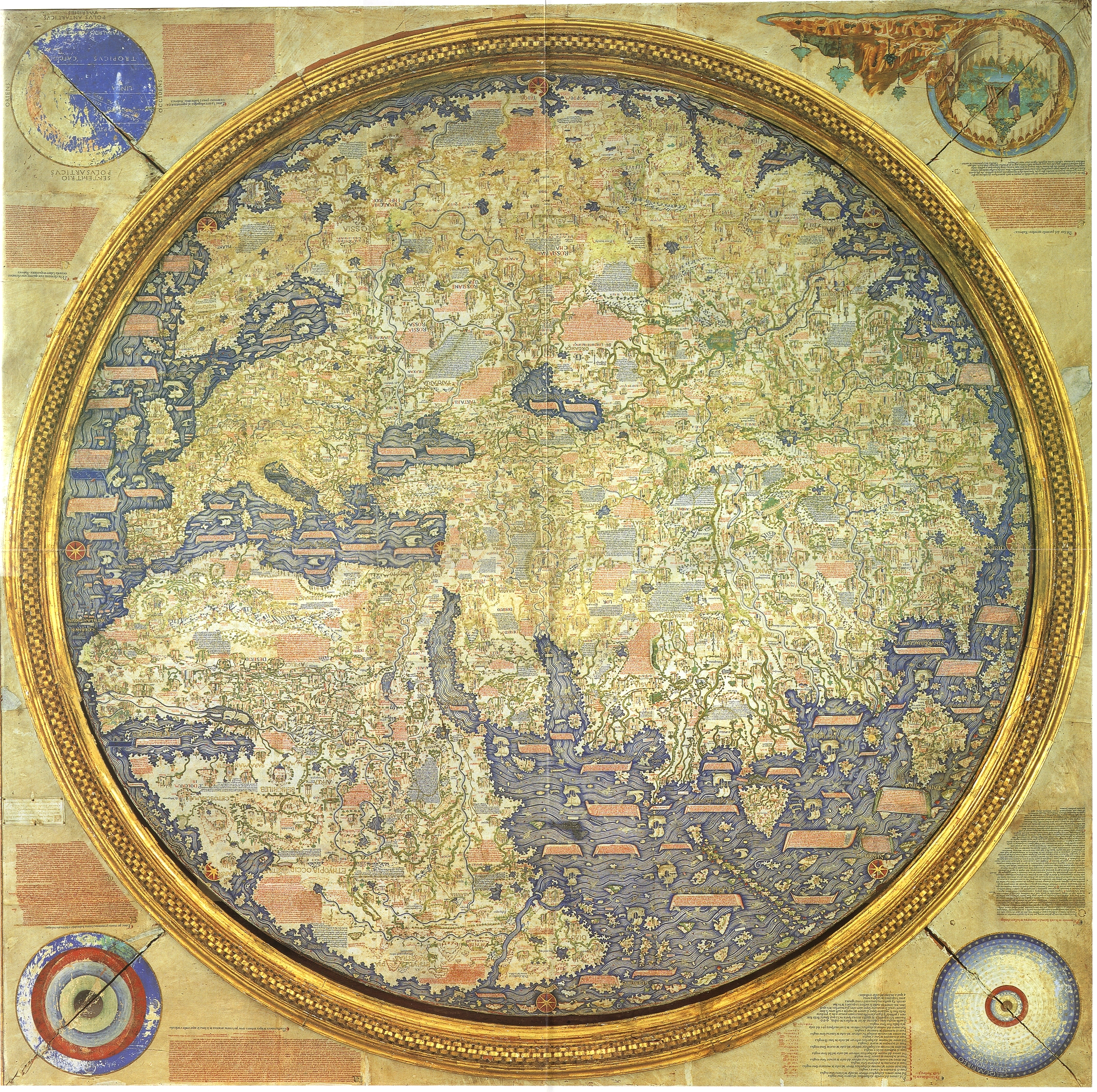
Inverted map of Fra Mauro (1460). Source "The Fra Mauro World map" Piero Falchetta.
Leyfisupplýsingar:
|
This is a faithful photographic reproduction of a two-dimensional, public domain work of art. The work of art itself is in the public domain for the following reason:
The official position taken by the Wikimedia Foundation is that "faithful reproductions of two-dimensional public domain works of art are public domain".
This photographic reproduction is therefore also considered to be in the public domain in the United States. In other jurisdictions, re-use of this content may be restricted; see Reuse of PD-Art photographs for details. | ||||
Breytingaskrá skjals
Smelltu á dagsetningu eða tímasetningu til að sjá hvernig hún leit þá út.
| Dagsetning/Tími | Smámynd | Víddir | Notandi | Athugasemd | |
|---|---|---|---|---|---|
| núverandi | 10. september 2016 kl. 10:15 | | 2.255 × 2.245 (6,48 MB) | Countakeshi | This image is suppose to be North-South as opposed to the original File:FraMauroDetailedMap.jpg which is South-North |
| 14. júlí 2016 kl. 00:16 |  | 2.240 × 2.240 (6,45 MB) | Llann Wé² | Original map with inverted poles | |
| 12. júlí 2016 kl. 00:19 |  | 2.255 × 2.245 (6,48 MB) | Cckerberos | Reverted to version as of 12:18, 1 May 2007 (UTC) | |
| 23. mars 2016 kl. 17:01 |  | 2.240 × 2.240 (6,45 MB) | SteinsplitterBot | Bot: Image rotated by 180° | |
| 1. maí 2007 kl. 12:18 |  | 2.255 × 2.245 (6,48 MB) | World Imaging | Better definition. | |
| 1. maí 2007 kl. 12:05 |  | 564 × 561 (375 KB) | World Imaging | Inverted map of Fra Mauro (1460). Source "The Fra Mauro World map" Piero Falchetta. |
Skráartenglar
Eftirfarandi síða notar þessa skrá:
Altæk notkun skráar
Eftirfarandi wikar nota einnig þessa skrá:
- Notkun á af.wikipedia.org
- Notkun á azb.wikipedia.org
- Notkun á be.wikipedia.org
- Notkun á bn.wikipedia.org
- Notkun á ca.wikipedia.org
- Notkun á cs.wikipedia.org
- Notkun á cv.wikipedia.org
- Notkun á de.wikipedia.org
- Notkun á de.wikibooks.org
- Notkun á en.wikipedia.org
- Notkun á eo.wikipedia.org
- Notkun á es.wikipedia.org
- Notkun á et.wikipedia.org
- Notkun á fa.wikipedia.org
- Notkun á fa.wikibooks.org
- Notkun á fr.wikipedia.org
- Notkun á gu.wikipedia.org
- Notkun á he.wikipedia.org
Skoða frekari altæka notkun þessarar skráar.