
Mynd:Austria 1945-55.png

Stærð þessarar forskoðunar: 800 × 310 mynddílar Aðrar upplausnir: 320 × 124 mynddílar | 640 × 248 mynddílar | 1.400 × 542 mynddílar.
Upphafleg skrá (1.400 × 542 mynddílar, skráarstærð: 60 KB, MIME-gerð: image/png)
Lýsing
| Lýsing |
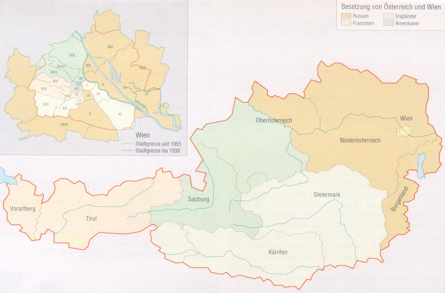
English: Occupied zones in Austria, 1945–1955.
Deutsch: Besatzungszonen in Österreich, 1945–1955.
Español: Zonas ocupadas por los aliados en Austria, 1945–1955.
Português: Zonas ocupadas pelos aliados na Áustria, 1945–1955.
Русский: Оккупационные зоны в Австрии, 1945–1955.
Български: Окупационни зони в Австрия, 1945–1955. |
| Dagsetning | |
| Uppruni | Original version |
| Höfundarréttarhafi |
Original by C.Lingg last update by Gugganij |

|
File:Austria Occupation Zones 1945-55.svg is a vector version of this file. It should be used in place of this PNG file when not inferior.
File:Austria 1945-55.png → File:Austria Occupation Zones 1945-55.svg
For more information, see Help:SVG. |
 |
Leyfisupplýsingar:
| I, the copyright holder of this work, release this work into the public domain. This applies worldwide. In some countries this may not be legally possible; if so: I grant anyone the right to use this work for any purpose, without any conditions, unless such conditions are required by law. |
| Annotations | This image is annotated: View the annotations at Commons |

Breytingaskrá skjals
Smelltu á dagsetningu eða tímasetningu til að sjá hvernig hún leit þá út.
| Dagsetning/Tími | Smámynd | Víddir | Notandi | Athugasemd | |
|---|---|---|---|---|---|
| núverandi | 8. nóvember 2009 kl. 22:18 | 1.400 × 542 (60 KB) | Gugganij | corrected colours of Vienna | |
| 13. september 2008 kl. 16:13 | 1.400 × 542 (80 KB) | IJA | Changed UK areas to green from the previous horrid brown/ grey colour. Looks better now and it also corresponds with the German Occupation zone version. | ||
| 26. apríl 2008 kl. 14:43 | 1.400 × 542 (80 KB) | Möchtegern | Occupied zones in Austria, 1945-1955 drawn by Christoph Lingg, 21.08.2005 {{PD-self}} {{SVG|map}} Category:Maps of the history of Austria | ||
| 14. október 2007 kl. 13:56 | 1.400 × 542 (59 KB) | C.lingg | Fixed the american flag. it contains now 48 stars. | ||
| 21. ágúst 2005 kl. 17:13 | 1.400 × 542 (58 KB) | C.lingg | Occupied Austria, 1945-1955. selfmade, source: http://www.aeiou.at/aeiou.encyclop.data.image.b/b397245b.jpg {{PD}} | ||
| 29. júlí 2005 kl. 13:04 |  | 1.500 × 1.027 (128 KB) | Karl Gruber | map colored by myself 7/2005 | |
| 29. júlí 2005 kl. 05:27 |  | 1.490 × 771 (6 KB) | Phrood~commonswiki | GFDL, drawn by Kagru, converted to png by Phrood |
Skráartenglar
Eftirfarandi síða notar þessa skrá:
Altæk notkun skráar
Eftirfarandi wikar nota einnig þessa skrá:
- Notkun á be.wikipedia.org
- Notkun á bs.wikipedia.org
- Notkun á ca.wikipedia.org
- Notkun á cs.wikipedia.org
- Notkun á cy.wikipedia.org
- Notkun á da.wikipedia.org
- Notkun á de.wikipedia.org
- Notkun á en.wikipedia.org
- Notkun á eo.wikipedia.org
- Notkun á et.wikipedia.org
- Notkun á fr.wikipedia.org
- Histoire de l'Autriche
- Anschluss
- Traité d'État autrichien
- Portail:Autriche
- Portail:Autriche/Histoire
- Occupation de l'Autriche après la Seconde Guerre mondiale
- Discussion:Occupation de l'Autriche après la Seconde Guerre mondiale
- Wikipédia:Le saviez-vous ?/Archives/2014
- Utilisateur:GhosterBot/BacASable/testStat bis/Visibilité des anecdotes (2014)
- Utilisateur:GhosterBot/BacASable/testStat b/Visibilité des anecdotes (2014)
- Utilisateur:GhosterBot/BacASable/testStat/Visibilité des anecdotes (2014)
- Wikipédia:Statistiques des anecdotes de la page d'accueil/Visibilité des anecdotes (2014)
- Wikipédia:Statistiques des anecdotes de la page d'accueil/Visibilité des anecdotes (2014)/2014 12
- Discussion:Kalash (peuple)/LSV 20378
- Notkun á he.wikipedia.org
- Notkun á hr.wikipedia.org
- Notkun á hu.wikipedia.org
- Notkun á hy.wikipedia.org
- Notkun á it.wikipedia.org
- Notkun á ka.wikipedia.org
- Notkun á lt.wikipedia.org
- Notkun á lv.wikipedia.org
- Notkun á nl.wikipedia.org
- Notkun á no.wikipedia.org
- Notkun á pt.wikipedia.org
- Notkun á ro.wikipedia.org
Skoða frekari altæka notkun þessarar skráar.