
Mynd:Atlantic hurricane tracks.jpg

Stærð þessarar forskoðunar: 800 × 448 mynddílar Aðrar upplausnir: 320 × 179 mynddílar | 640 × 359 mynddílar | 1.024 × 574 mynddílar | 1.280 × 717 mynddílar | 2.560 × 1.435 mynddílar | 9.000 × 5.044 mynddílar.
Upphafleg skrá (9.000 × 5.044 mynddílar, skráarstærð: 35,69 MB, MIME-gerð: image/jpeg)
| Saffir-Simpson Hurricane Scale | ||||||
| TD | TS | 1 | 2 | 3 | 4 | 5 |
Lýsing
| Lýsing |
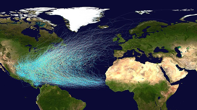
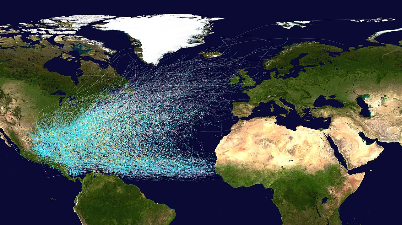
English: This map shows the tracks of all Atlantic hurricanes which formed between 1851 and 2019. The points show the locations of the storms at six-hourly intervals and use the color scheme shown to the right from Saffir-Simpson Hurricane Scale. |
||
| Uppruni |
Created using User:jdorje/Tracks by Nilfanion on 2006-08-05. Background image from File:Whole world - land and oceans.jpg (NASA). Tracking data for storms is from the National Hurricane Center.[1] |
||
| Höfundarréttarhafi | Nilfanion | ||
| Réttindi (Endurnotkun á þessari skrá) |
|
||
| Aðrar útgáfur |
This file was derived from: Whole world - land and oceans.jpg: |
Leyfisupplýsingar:
| I, the copyright holder of this work, release this work into the public domain. This applies worldwide. In some countries this may not be legally possible; if so: I grant anyone the right to use this work for any purpose, without any conditions, unless such conditions are required by law. |
Breytingaskrá skjals
Smelltu á dagsetningu eða tímasetningu til að sjá hvernig hún leit þá út.
| Dagsetning/Tími | Smámynd | Víddir | Notandi | Athugasemd | |
|---|---|---|---|---|---|
| núverandi | 10. ágúst 2020 kl. 02:07 | | 9.000 × 5.044 (35,69 MB) | Supportstorm | Updated to show years up to 2019 and changes to HURDAT |
| 24. júní 2013 kl. 20:28 |  | 9.000 × 5.562 (38,2 MB) | Supportstorm | Updated to show years up to 2012 and subsequent changes to HURDAT | |
| 5. ágúst 2006 kl. 19:34 |  | 4.000 × 2.472 (2,61 MB) | Nilfanion | == Summary == {|align="{{{align|right}}}" border="0" cellspacing="0" cellpadding="0" style="background:transparent;text-align:center" |- |colspan="7" nowrap="nowrap"| <small>Saffir-Simpson Hurricane Scale</small> |- |s |
Skráartenglar
Eftirfarandi síða notar þessa skrá:
Altæk notkun skráar
Eftirfarandi wikar nota einnig þessa skrá:
- Notkun á ar.wikipedia.org
- Notkun á bn.wikipedia.org
- Notkun á de.wikipedia.org
- Notkun á el.wikipedia.org
- Notkun á en.wikipedia.org
- Bermuda Triangle
- Atlantic hurricane
- Wikipedia:WikiProject Tropical cyclones/Project resources
- Hurricane Alley
- Wikipedia:Reference desk/Archives/Science/2009 January 30
- User:Fdizile/All Knowladge
- Wikipedia talk:WikiProject Tropical cyclones/Archive 41
- Wikipedia:WikiProject Tropical cyclones/Atlantic hurricane season good topic
- User:Chicdat/sandbox
- Wikipedia:WikiProject Weather/Project resources
- Wikipedia:WikiProject Weather/Project resources/Tropical cyclone
- Talk:Atlantic hurricane/Archive 1
- Notkun á es.wikipedia.org
- Notkun á eu.wikipedia.org
- Notkun á hy.wikipedia.org
- Notkun á id.wikipedia.org
- Notkun á ms.wikipedia.org
- Notkun á nl.wikipedia.org
- Notkun á pl.wikipedia.org
- Notkun á ru.wikipedia.org
- Notkun á simple.wikipedia.org
- Notkun á uk.wikipedia.org
- Notkun á vi.wikipedia.org
- Notkun á www.wikidata.org
- Notkun á zh.wikipedia.org