
Mynd:Timberlake-map-tanasi-1765.jpg
Það er engin hærri upplausn til.
Timberlake-map-tanasi-1765.jpg (434 × 286 mynddílar, skráarstærð: 44 KB, MIME-gerð: image/jpeg)
Lýsing
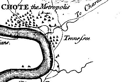
| Lýsing | Detail of Henry Timberlake's 1762 (published 1765) "Draught of the Cherokee Country" showing Tanasi. Timberlake's spelling of Tanasi as "Tennessee" is one of the first widely published uses of this spelling of the state's namesake. Tanasi declined after 1730 and by Timberlake's time had been overshadowed by neighboring Chota. The bend in the river is Bacon's Bend. |
| Dagsetning | |
| Uppruni | Henry Timberlake, Memoirs (1765) |
| Höfundarréttarhafi | Henry Timberlake |
| Aðrar útgáfur |
|

Leyfisupplýsingar:
|
This work is in the public domain in its country of origin and other countries and areas where the copyright term is the author's life plus 100 years or fewer. | |
| This file has been identified as being free of known restrictions under copyright law, including all related and neighboring rights. | |
Breytingaskrá skjals
Smelltu á dagsetningu eða tímasetningu til að sjá hvernig hún leit þá út.
| Dagsetning/Tími | Smámynd | Víddir | Notandi | Athugasemd | |
|---|---|---|---|---|---|
| núverandi | 27. mars 2008 kl. 22:09 | | 434 × 286 (44 KB) | BrineStans | {{Information |Description=Detail of Henry Timberlake's 1762 (published 1765) "Draught of the Cherokee Country" showing Tanasi. Timberlake's spelling of Tanasi as "Tennessee" is one of the first widely published uses of this spelling of the state's names |
Skráartenglar
Það eru engar síður sem nota þessa skrá.
Altæk notkun skráar
Eftirfarandi wikar nota einnig þessa skrá:
- Notkun á arz.wikipedia.org
- Notkun á da.wikipedia.org
- Notkun á en.wikipedia.org
- Notkun á pl.wikipedia.org
- Notkun á vi.wikipedia.org