
Mynd:Stalingrad - Preparations for Operation Uranus.png
Stærð þessarar forskoðunar: 800 × 492 mynddílar Aðrar upplausnir: 320 × 197 mynddílar | 640 × 394 mynddílar | 1.024 × 630 mynddílar | 1.280 × 788 mynddílar | 2.560 × 1.576 mynddílar | 4.321 × 2.660 mynddílar.
Upphafleg skrá (4.321 × 2.660 mynddílar, skráarstærð: 2,83 MB, MIME-gerð: image/png)

|
This map image could be re-created using vector graphics as an SVG file. This has several advantages; see Commons:Media for cleanup for more information. If an SVG form of this image is available, please upload it and afterwards replace this template with
{{vector version available|new image name}}.
It is recommended to name the SVG file “Stalingrad - Preparations for Operation Uranus.svg”—then the template Vector version available (or Vva) does not need the new image name parameter. |
Lýsing
| Lýsing |
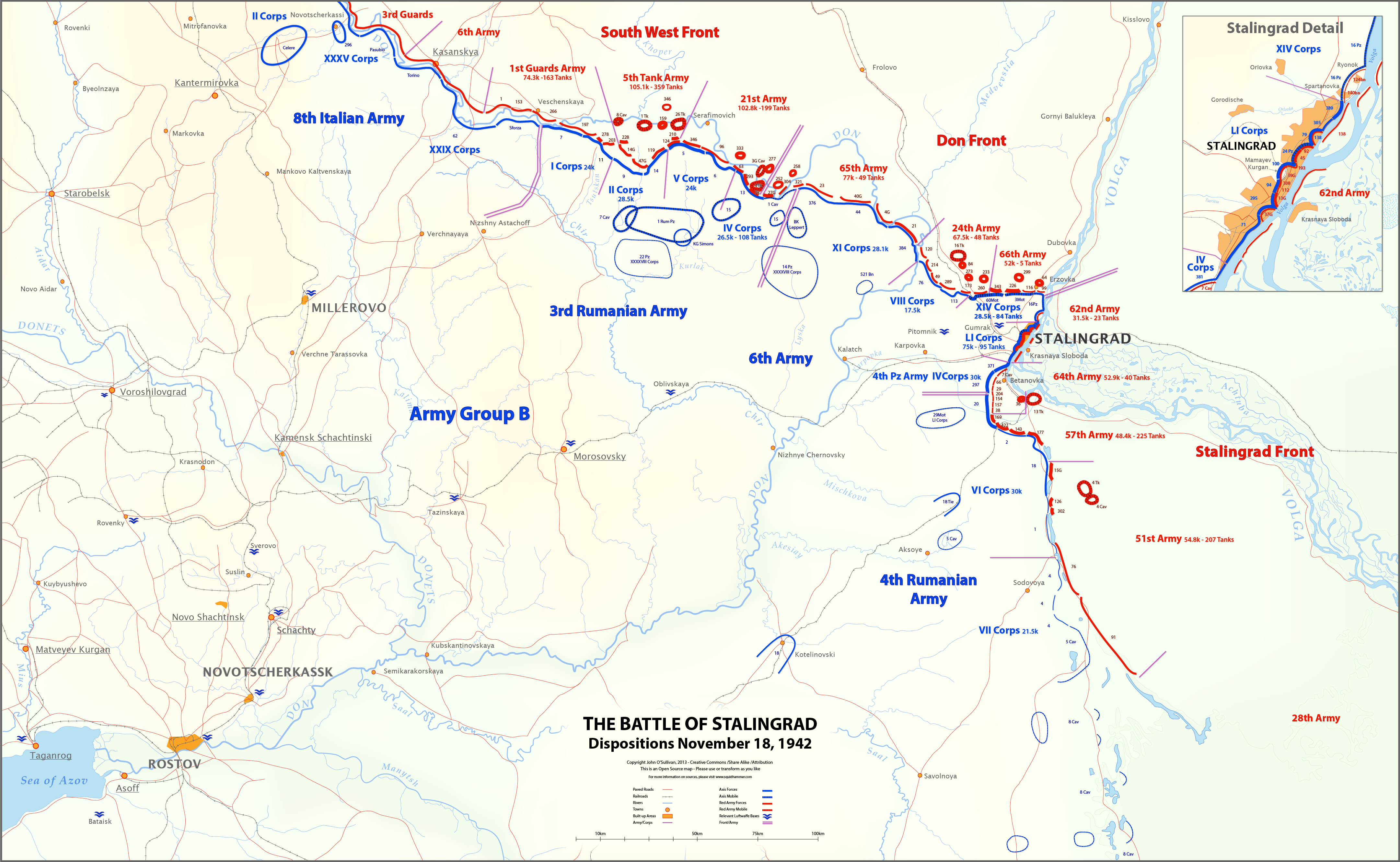
English: This map shows unit locations and relative strengths for Axis and Soviet Armies on Nov 18, 1942, during the Battle of Stalingrad.
On November 19, the Soviets launched Operation Uranus, an offensive designed to isolate and destroy the German 6th Army at Stalingrad. |
| Dagsetning | |
| Uppruni | eigin skrá |
| Höfundarréttarhafi | Josullivan.59 |
| Aðrar útgáfur |
 |
Sources:
Books and Articles
| Author | Title | Notes |
| Alexei V. Isaev | Stalingrad: The Volga No Land For Us | Soviet forces and tanks |
| Antony Beevor | Stalingrad-The-Fateful-Siege-1942-1943 | Most widely cited Order of Battle |
| Wikipedia | Red Army Order of Battle Stalingrad | Useful |
| Wikipedia | Axis order of battle at the Battle of Stalingrad | Not particularly useful |
| Staldata | Staldata | Axis and Soviet Orders of Battle & force strength |
| Wolf Höpper | Against the Flood - Operation Uranus (I) | German tank numbers |
| Joel S. A. Hayward | Stopped At Stalingrad: The Luftwaffe And Hitler's Defeat In The East 1942-1943 | Bases used for Airlift |
| Akhil Kadidal | Stalingrad Pocket | Really good maps and annotated photographs |
Maps
| Title | Source | Notes |
| OKH Situation Map Nov 18 42 | WW2 Photos Maps | Axis forces locations Fantastic Site! |
| OKH Situation Map Nov 18 42 2 | WW2 Photos Maps | Axis forces locations Fantastic Site! |
| S4231 Summary of combat operations in Stalingrad | Armchair General/RIIAWW2 | Red Army locations Excellent map |
| S4239 Operations in Stalingrad area | RIIAWW2 Armchair General/RIIAWW2 | Red Army locations |
| S4251 Combat operations of the South-Western, Don and Stalingrad Fronts | Armchair General/RIIAWW2 | Red Army locations |
Notes:
- My Order of Battle is here.
- There are more units listed in the Order of Battle than appear on the map. I didn't place any unit on the map unless I could find it in one of the source maps.
- In conflicts between locations on the OKH map and the Soviet maps, I used the Soviet map. The Germans had not picked up the Uranus build-up, so the Soviets had much better intelligence at this time.
- I could find no information on the strength of the 8th Italian Army, or Soviet 6th and 3rd Guards Armies.
- Unit lines are thicker or thinner based on strength and density. These are characterizations, not precise measurements.
- Unit strengths are shown in the layers in the SVG version of the map. These are based on the Order of Battle spreadsheet linked above. The spreadsheet includes notes on the units shown on the map.
- The base map is derived from the OKH maps. I do not know the map projection.
- Please feel free to comment on any inaccuracies! You can help to make the map better. I'm particularly interested in proper place-names.
- Þér er frjálst:
- að deila – að afrita, deila og yfirfæra verkið
- að blanda – að breyta verkinu
- Undir eftirfarandi skilmálum:
- tilvísun höfundarréttar – Þú verður að tilgreina viðurkenningu á höfundarréttindum, gefa upp tengil á notkunarleyfið og gefa til kynna ef breytingar hafa verið gerðar. Þú getur gert þetta á einhvern ásættanlegan máta, en ekki á nokkurn þann hátt sem bendi til þess að leyfisveitandinn styðji þig eða notkun þína á verkinu.
- Deila eins – Ef þú breytir, yfirfærir eða byggir á þessu efni, þá mátt þú eingöngu dreifa því verki með sama eða svipuðu leyfi og upprunalega verkið er með.
Leyfisupplýsingar:
I, the copyright holder of this work, hereby publish it under the following license:
Þessi skrá er með Creative Commons Tilvísun-DeilaEins 3.0 Óstaðfært notkunarleyfi.
Breytingaskrá skjals
Smelltu á dagsetningu eða tímasetningu til að sjá hvernig hún leit þá út.
| Dagsetning/Tími | Smámynd | Víddir | Notandi | Athugasemd | |
|---|---|---|---|---|---|
| núverandi | 12. mars 2013 kl. 18:27 | | 4.321 × 2.660 (2,83 MB) | Josullivan.59 | Fixed the licensing information on the map. |
| 12. mars 2013 kl. 18:13 |  | 4.322 × 2.660 (3,89 MB) | Josullivan.59 | User created page with UploadWizard |
Skráartenglar
Það eru engar síður sem nota þessa skrá.
Altæk notkun skráar
Eftirfarandi wikar nota einnig þessa skrá:
- Notkun á de.wikipedia.org
- Notkun á en.wikipedia.org
- Notkun á es.wikipedia.org
- Notkun á fi.wikipedia.org
- Notkun á fr.wikipedia.org
- Notkun á ja.wikipedia.org
- Notkun á no.wikipedia.org
- Notkun á pt.wikipedia.org
- Notkun á uk.wikipedia.org