
Mynd:Keswick, Cumbria Panorama 1 - June 2009.jpg

Stærð þessarar forskoðunar: 799 × 183 mynddílar Aðrar upplausnir: 320 × 73 mynddílar | 640 × 147 mynddílar | 1.024 × 235 mynddílar | 1.280 × 293 mynddílar | 2.560 × 586 mynddílar | 17.888 × 4.098 mynddílar.
Upphafleg skrá (17.888 × 4.098 mynddílar, skráarstærð: 19,75 MB, MIME-gerð: image/jpeg)
| Warning | The original file is very high-resolution. It might not load properly or could cause your browser to freeze when opened at full size. |
|---|
|

Lýsing
| Lýsing |
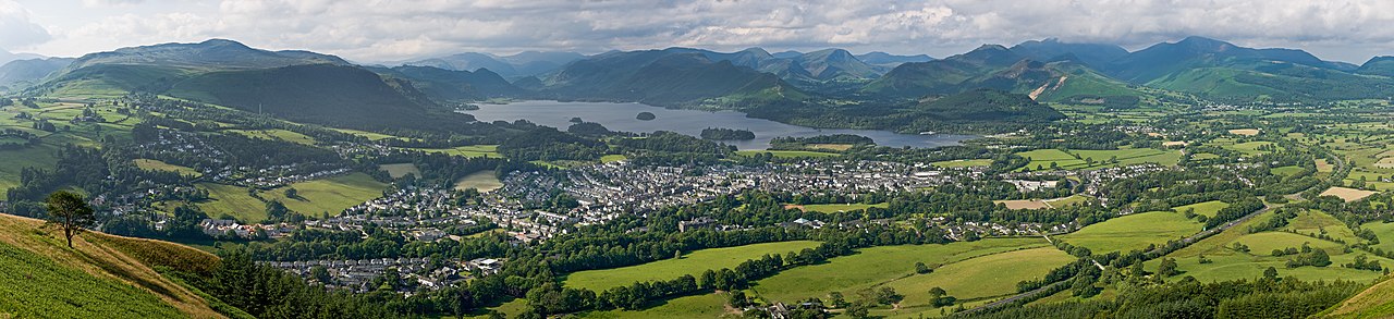
English: A 2 x 16 segment panorama of Keswick, Cumbria, England, as viewed from Latrigg north of the town.
Français : Panorama de 2x16 photos de la ville de Keswick en Cumbrie, en Angleterre, au Royaume-Uni. |
| Dagsetning | |
| Uppruni | eigin skrá |
| Höfundarréttarhafi | Diliff |
| Réttindi (Endurnotkun á þessari skrá) |
Summary:In using this image or any subsequent derivatives of it, you are required to release the image under the same license. As such, any reproduction of this image, in any medium, must appear with a copy of, or full URL of the license.Attribution of this image to the author (DAVID ILIFF) is also required, preferably in a prominent location near the image.No other conditions may be added to, or removed from this license without the permission of the author and copyright holder.Suggested attribution: "Photo by DAVID ILIFF. License: CC BY-SA 3.0"Please review the full license requirements carefully before using this image. If you would like to clarify the terms of the license or negotiate less restrictive commercial licensing outside of the bounds of GFDL/CC-BY-SA, please contact me by email, or if you don't have a Wikipedia account you can either leave a message on my talk page with your contact details and your request, or you can contact me on Facebook. Please also send a 'friend request' to ensure that I am aware of your message. |
| Aðrar útgáfur |
  |
.jpg)
| Camera location | | View this and other nearby images on: OpenStreetMap |
|---|
Leyfisupplýsingar:
I, the copyright holder of this work, hereby publish it under the following licenses:
Þessi skrá er með Creative Commons Tilvísun-DeilaEins 3.0 Óstaðfært notkunarleyfi.
- Þér er frjálst:
- að deila – að afrita, deila og yfirfæra verkið
- að blanda – að breyta verkinu
- Undir eftirfarandi skilmálum:
- tilvísun höfundarréttar – Þú verður að tilgreina viðurkenningu á höfundarréttindum, gefa upp tengil á notkunarleyfið og gefa til kynna ef breytingar hafa verið gerðar. Þú getur gert þetta á einhvern ásættanlegan máta, en ekki á nokkurn þann hátt sem bendi til þess að leyfisveitandinn styðji þig eða notkun þína á verkinu.
- Deila eins – Ef þú breytir, yfirfærir eða byggir á þessu efni, þá mátt þú eingöngu dreifa því verki með sama eða svipuðu leyfi og upprunalega verkið er með.

|
Gefið er leyfi til að afrita, dreifa og/eða breyta þessu skjali samkvæmt Frjálsa GNU Free Documentation License, útgáfu 1.2 eða nýrri, sem gefið er út af Frjálsu hugbúnaðarstofnuninni með engum breytingum þar á. Afrit af leyfinu er innifalið í kaflanum GNU Free Documentation License. |
Þú mátt velja notkunarleyfi að eigin vali.
This image has been assessed using the Quality image guidelines and is considered a Quality image.
|
Breytingaskrá skjals
Smelltu á dagsetningu eða tímasetningu til að sjá hvernig hún leit þá út.
| Dagsetning/Tími | Smámynd | Víddir | Notandi | Athugasemd | |
|---|---|---|---|---|---|
| núverandi | 6. júlí 2009 kl. 11:56 | 17.888 × 4.098 (19,75 MB) | Neokortex | Reverted to version as of 19:16, 29 June 2009 | |
| 6. júlí 2009 kl. 09:22 | 17.888 × 4.098 (13,25 MB) | M 93 | weniger Speicherplatz | ||
| 29. júní 2009 kl. 19:16 | 17.888 × 4.098 (19,75 MB) | Diliff | minor fix, less sharpening applied | ||
| 28. júní 2009 kl. 22:44 | 17.888 × 4.098 (25,26 MB) | Diliff | reprocessed... less haze and higher res | ||
| 28. júní 2009 kl. 18:10 | 13.592 × 3.134 (12,31 MB) | Diliff | {{Information |Description={{en|1=A 2 x 16 segment panorama of Keswick, Cumbria, England, as viewed from Latrigg north of the town.}} |Source=Own work by uploader |Author=Diliff |Date=2009-06-26 |Permission={{Diliff/Licensing}} |other_vers |
Skráartenglar
Það eru engar síður sem nota þessa skrá.
Altæk notkun skráar
Eftirfarandi wikar nota einnig þessa skrá:
- Notkun á ar.wikipedia.org
- Notkun á de.wikipedia.org
- Notkun á en.wikipedia.org
- Keswick, Cumbria
- User:Diliff
- Wikipedia:Featured pictures/Places/Panorama
- The Tale of Benjamin Bunny
- Wikipedia:Featured pictures thumbs/18
- Wikipedia:Featured picture candidates/July-2009
- Wikipedia:Featured picture candidates/File:Keswick, Cumbria Panorama 1 - June 2009.jpg
- Wikipedia:Wikipedia Signpost/2009-07-27/Features and admins
- Portal:Cumbria/Selected picture
- Portal:Cumbria/Selected picture/7
- Wikipedia:Picture of the day/September 2010
- Portal:Cumbria
- User talk:Diliff/Archive7
- Template:POTD/2010-09-21
- User talk:Diliff/Archive8
- Wikipedia:Wikipedia Signpost/2009-07-27/SPV
- Talk:Keswick, Cumbria/Archive 1
- Wikipedia:Wikipedia Signpost/Single/2009-07-27
- Notkun á fr.wikipedia.org
- Notkun á nl.wikipedia.org
- Notkun á pa.wikipedia.org
- Notkun á pl.wikipedia.org
- Notkun á pt.wikipedia.org
- Notkun á ru.wikipedia.org
- Notkun á vi.wikipedia.org