
Mynd:Iceland Mid-Atlantic Ridge map.svg

Stærð þessarar PNG forskoðunar á SVG skránni: 376 × 390 mynddílar. Aðrar upplausnir: 231 × 240 mynddílar | 463 × 480 mynddílar | 740 × 768 mynddílar | 987 × 1.024 mynddílar | 1.974 × 2.048 mynddílar.
Upphafleg skrá (SVG-skrá, að nafni til 376 × 390 mynddílar, skráarstærð: 129 KB)
Lýsing
| Lýsing | |
| Dagsetning | |
| Uppruni | http://pubs.usgs.gov/gip/dynamic/understanding.html |
| Höfundarréttarhafi | http://pubs.usgs.gov/gip/dynamic/understanding.html |
| Aðrar útgáfur |
|


Leyfisupplýsingar:
This image is in the public domain in the United States because it only contains materials that originally came from the United States Geological Survey, an agency of the United States Department of the Interior. For more information, see the official USGS copyright policy.
|
| Annotations | This image is annotated: View the annotations at Commons |
Breytingaskrá skjals
Smelltu á dagsetningu eða tímasetningu til að sjá hvernig hún leit þá út.
| Dagsetning/Tími | Smámynd | Víddir | Notandi | Athugasemd | |
|---|---|---|---|---|---|
| núverandi | 10. janúar 2014 kl. 18:48 | | 376 × 390 (129 KB) | Amitchell125 | text improved |
| 26. febrúar 2010 kl. 14:42 |  | 376 × 390 (68 KB) | Beao | Tweak. | |
| 26. febrúar 2010 kl. 14:40 |  | 376 × 390 (68 KB) | Beao | Tweak. | |
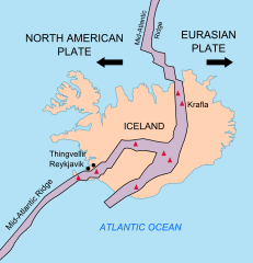
| 26. febrúar 2010 kl. 14:37 |  | 376 × 390 (68 KB) | Beao | == Summary == {{Information |Description={{en|1=Map showing the Mid-Atlantic Ridge splitting Iceland and separating the North American and Eurasian Plates. The map also shows Reykjavik, the capital of Iceland, the Thingvellir area, and the locations of so |
Skráartenglar
Það eru engar síður sem nota þessa skrá.
Altæk notkun skráar
Eftirfarandi wikar nota einnig þessa skrá:
- Notkun á be-tarask.wikipedia.org
- Notkun á bn.wikipedia.org
- Notkun á ca.wikipedia.org
- Notkun á en.wikipedia.org
- Notkun á en.wikivoyage.org
- Notkun á fi.wikipedia.org
- Notkun á hr.wikipedia.org
- Notkun á id.wikipedia.org
- Notkun á it.wikipedia.org
- Notkun á ko.wikipedia.org
- Notkun á lb.wikipedia.org
- Notkun á nl.wikipedia.org
- Notkun á no.wikipedia.org
- Notkun á pl.wikipedia.org
- Notkun á simple.wikipedia.org
- Notkun á sl.wikipedia.org
- Notkun á sr.wikipedia.org
- Notkun á sv.wikipedia.org
- Notkun á tr.wikipedia.org
- Notkun á uk.wikipedia.org
- Notkun á zh.wikipedia.org
- Notkun á zh.wikivoyage.org