
Mynd:Greater London population density map, 2011 census.png

Upphafleg skrá (3.896 × 3.178 mynddílar, skráarstærð: 15,52 MB, MIME-gerð: image/png)
Lýsing
| Lýsing |
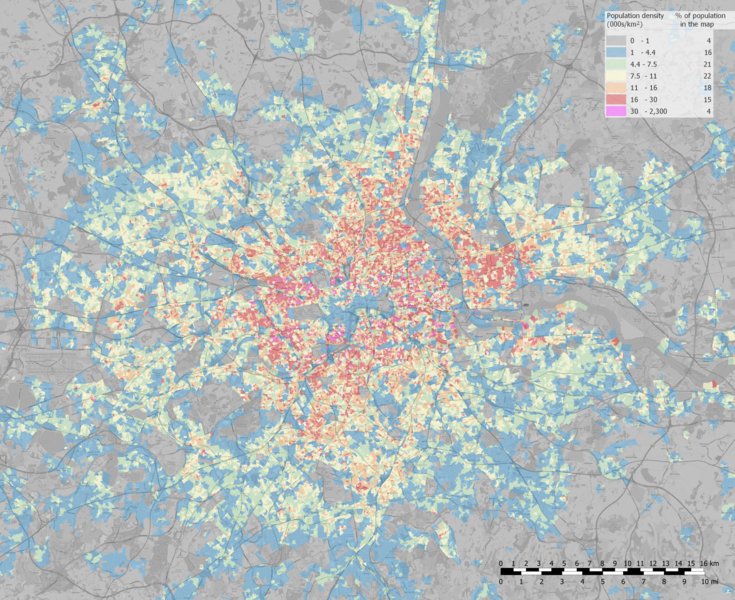
English: The map area was inhabited by 9.4 mln people in 2011 and shows most of Greater London Built-up Area (9.8 mln people in 2011) and some areas outside it.
Population density computed from 2011 Output Area (OE) data there is on 2020 map so new neighbourhoods are visible in the grey zone. Values sometimes are not representative because:
Polski: Obszar mapy był zamieszkany jest przez 9,4 mln. ludzi w 2011 i pokazuje większość obszaru zabudowanego Londynu (9,8 mln ludzi w 2011) i trochę obszarów poza nim.
Gęstość zaludnienia obliczona jest z danych Output Area (OE) z 2011 i jest na mapie z 2020, tak więc widać nowe osiedla w szarej strefie. Wartości czasami nie są reprezentacyjne ponieważ:
|
| Dagsetning | |
| Uppruni |
Own work based on: OpenStreetMap. Boundaries: Office for National Statistics (2011). 2011 Census: boundary data (England and Wales) [data collection]. UK Data Service. SN:5819 UKBORDERS: Digitised Boundary Data, 1840- and Postcode Directories, 1980-. http://discover.ukdataservice.ac.uk/catalogue/?sn=5819&type=Data%20catalogue, Retrieved from http://census.ukdataservice.ac.uk/get-data/boundary-data.aspx. Contains public sector information licensed under the Open Government Licence v3. Density values: Office for National Statistics ; National Records of Scotland ; Northern Ireland Statistics and Research Agency (2017): 2011 Census aggregate data. UK Data Service (Edition: February 2017). DOI: https://dx.doi.org/10.5257/census/aggregate-2011-2 This information is licensed under the terms of the Open Government Licence [1]. |
| Höfundarréttarhafi | PawełS |
Contains NRS data © Crown copyright and database right [2020]
Contains OS data © Crown copyright [and database right] (2020)
Leyfisupplýsingar:
- Þér er frjálst:
- að deila – að afrita, deila og yfirfæra verkið
- að blanda – að breyta verkinu
- Undir eftirfarandi skilmálum:
- tilvísun höfundarréttar – Þú verður að tilgreina viðurkenningu á höfundarréttindum, gefa upp tengil á notkunarleyfið og gefa til kynna ef breytingar hafa verið gerðar. Þú getur gert þetta á einhvern ásættanlegan máta, en ekki á nokkurn þann hátt sem bendi til þess að leyfisveitandinn styðji þig eða notkun þína á verkinu.
- Deila eins – Ef þú breytir, yfirfærir eða byggir á þessu efni, þá mátt þú eingöngu dreifa því verki með sama eða svipuðu leyfi og upprunalega verkið er með.
Breytingaskrá skjals
Smelltu á dagsetningu eða tímasetningu til að sjá hvernig hún leit þá út.
| Dagsetning/Tími | Smámynd | Víddir | Notandi | Athugasemd | |
|---|---|---|---|---|---|
| núverandi | 3. maí 2020 kl. 10:55 | | 3.896 × 3.178 (15,52 MB) | PawełS | Uploaded own work with UploadWizard |
Skráartenglar
Það eru engar síður sem nota þessa skrá.
Altæk notkun skráar
Eftirfarandi wikar nota einnig þessa skrá:
- Notkun á arz.wikipedia.org
- Notkun á de.wikipedia.org
- Notkun á en.wikipedia.org
- Notkun á ko.wikipedia.org
- Notkun á sl.wikipedia.org
- Notkun á tr.wikipedia.org
- Notkun á ur.wikipedia.org