
Mynd:Geo Map of Median Income by Location in Tennessee.png

Stærð þessarar forskoðunar: 800 × 406 mynddílar Aðrar upplausnir: 320 × 162 mynddílar | 640 × 325 mynddílar | 1.024 × 520 mynddílar | 1.738 × 882 mynddílar.
Upphafleg skrá (1.738 × 882 mynddílar, skráarstærð: 603 KB, MIME-gerð: image/png)
Lýsing
| Lýsing |
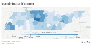
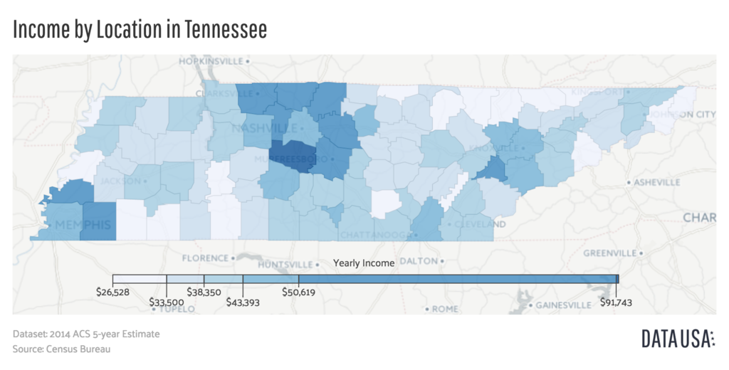
English: A geomap showing the counties of Tennessee colored by the relative range of that county's median income. Data is sourced from the 2014 ACS 5-year Estimate Report put out by the US Census Bureau |
| Dagsetning | |
| Uppruni | http://datausa.io/profile/geo/tennessee/#income_geo |
| Höfundarréttarhafi | Datawheel, LLC |
Leyfisupplýsingar:

|
This work is free software; you can redistribute it and/or modify it under the terms of the GNU Affero General Public License as published by the Free Software Foundation; either version 3 of the License, or any later version. This work is distributed in the hope that it will be useful, but without any warranty; without even the implied warranty of merchantability or fitness for a particular purpose. See version 3 of the GNU Affero General Public License for more details.
|
Breytingaskrá skjals
Smelltu á dagsetningu eða tímasetningu til að sjá hvernig hún leit þá út.
| Dagsetning/Tími | Smámynd | Víddir | Notandi | Athugasemd | |
|---|---|---|---|---|---|
| núverandi | 3. ágúst 2016 kl. 20:31 | | 1.738 × 882 (603 KB) | Mattrdini | User created page with UploadWizard |
Skráartenglar
Það eru engar síður sem nota þessa skrá.
Altæk notkun skráar
Eftirfarandi wikar nota einnig þessa skrá:
- Notkun á en.wikipedia.org
- Notkun á fa.wikipedia.org
- Notkun á ru.wikipedia.org
- Notkun á vi.wikipedia.org