
Mynd:Federal lands in Puerto Rico and VI.JPG
Stærð þessarar forskoðunar: 800 × 171 mynddílar Aðrar upplausnir: 320 × 68 mynddílar | 1.312 × 280 mynddílar.
Upphafleg skrá (1.312 × 280 mynddílar, skráarstærð: 47 KB, MIME-gerð: image/jpeg)
Lýsing

|
This file was moved to Wikimedia Commons from en.wikipedia using a bot script. All source information is still present. It requires review. Additionally, there may be errors in any or all of the information fields; information on this file should not be considered reliable and the file should not be used until it has been reviewed and any needed corrections have been made. Once the review has been completed, this template should be removed. For details about this file, see below. Check now! |
| Lýsing |
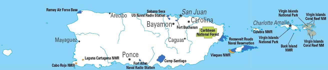
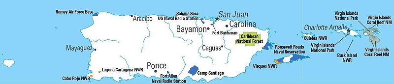
English: Federal lands in Puerto Rico and VI. |
| Dagsetning | (UTC) |
| Uppruni | http://www.nationalatlas.gov/printable/images/pdf/fedlands/prvi.pdf |
| Höfundarréttarhafi | USGS |
| Aðrar útgáfur | File:Federal Lands of Puerto Rico.pdf, File:Federal lands in Puerto RicoZ.JPG |
Leyfisupplýsingar:
This map was obtained from an edition of the National Atlas of the United States. Like almost all works of the U.S. federal government, works from the National Atlas are in the public domain in the United States.
Online access: NationalAtlas.gov | 1970 print edition: Library of Congress, Perry-Castañeda Library
|
This image is in the public domain in the United States because it only contains materials that originally came from the United States Geological Survey, an agency of the United States Department of the Interior. For more information, see the official USGS copyright policy.
|
Original upload log
The original description page was here. All following user names refer to en.wikipedia.
- 2010-03-17 22:22 Quazgaa 1312×280× (47771 bytes) {{Information |Description = Federal lands in Puerto Rico and VI. |Source = http://www.nationalatlas.gov/printable/images/pdf/fedlands/prvi.pdf |Date = ~~~~~ |Author = USGS |Permission = {{PD-USGov-Atlas}} |other_ver
Breytingaskrá skjals
Smelltu á dagsetningu eða tímasetningu til að sjá hvernig hún leit þá út.
| Dagsetning/Tími | Smámynd | Víddir | Notandi | Athugasemd | |
|---|---|---|---|---|---|
| núverandi | 12. janúar 2012 kl. 20:47 | 1.312 × 280 (47 KB) | MGA73bot2 | {{BotMoveToCommons|en.wikipedia|year={{subst:CURRENTYEAR}}|month={{subst:CURRENTMONTHNAME}}|day={{subst:CURRENTDAY}}}} {{Information |Description={{en|Federal lands in Puerto Rico and VI.}} |Source=Transferred from [http://en.wikipedia.org en.wikipedia] |
Skráartenglar
Það eru engar síður sem nota þessa skrá.
Altæk notkun skráar
Eftirfarandi wikar nota einnig þessa skrá:
- Notkun á en.wikipedia.org
- Notkun á ru.wikipedia.org