
Mynd:East Above Corniglia Cinque Terre crop Sep23 A7C 06797.jpg

Stærð þessarar forskoðunar: 799 × 599 mynddílar Aðrar upplausnir: 320 × 240 mynddílar | 640 × 480 mynddílar | 1.024 × 768 mynddílar | 1.280 × 960 mynddílar | 2.560 × 1.920 mynddílar | 4.626 × 3.470 mynddílar.
Upphafleg skrá (4.626 × 3.470 mynddílar, skráarstærð: 19,17 MB, MIME-gerð: image/jpeg)
Lýsing
| Lýsing |
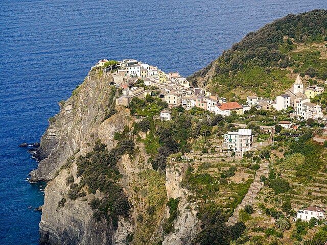
English: Corniglia perched on a 300 ft (91 m) cliff. View from the east, on Trail 587 Corniglia towards Volastra, about 260 m (850 ft) above the village. San Pietro Church middle right. Zigzag staircase down to the railway station lower right. Cinque Terre, Liguria, Italy |
|||
| Dagsetning | ||||
| Uppruni | eigin skrá | |||
| Höfundarréttarhafi |
|
|||
| Aðrar útgáfur |
|


| Camera location | | View this and other nearby images on: OpenStreetMap |
|---|
The geographical information in this file was retrospectively estimated.
The location may therefore be somewhat imprecise. Verifying and refining these coordinates is strongly encouraged. |
|
This place is a UNESCO World Heritage Site, listed as
Portovenere, Cinque Terre, and the Islands (Italy).
|
Assessment
|
Leyfisupplýsingar:
I, the copyright holder of this work, hereby publish it under the following license:
This file is licensed under the Creative Commons Attribution-Share Alike 4.0 International license.
- Þér er frjálst:
- að deila – að afrita, deila og yfirfæra verkið
- að blanda – að breyta verkinu
- Undir eftirfarandi skilmálum:
- tilvísun höfundarréttar – Þú verður að tilgreina viðurkenningu á höfundarréttindum, gefa upp tengil á notkunarleyfið og gefa til kynna ef breytingar hafa verið gerðar. Þú getur gert þetta á einhvern ásættanlegan máta, en ekki á nokkurn þann hátt sem bendi til þess að leyfisveitandinn styðji þig eða notkun þína á verkinu.
- Deila eins – Ef þú breytir, yfirfærir eða byggir á þessu efni, þá mátt þú eingöngu dreifa því verki með sama eða svipuðu leyfi og upprunalega verkið er með.
Breytingaskrá skjals
Smelltu á dagsetningu eða tímasetningu til að sjá hvernig hún leit þá út.
| Dagsetning/Tími | Smámynd | Víddir | Notandi | Athugasemd | |
|---|---|---|---|---|---|
| núverandi | 22. apríl 2024 kl. 04:26 | | 4.626 × 3.470 (19,17 MB) | Tagooty | Uploaded own work with UploadWizard |
Skráartenglar
Það eru engar síður sem nota þessa skrá.
Altæk notkun skráar
Eftirfarandi wikar nota einnig þessa skrá:
- Notkun á en.wikipedia.org
- Notkun á frp.wikipedia.org
- Notkun á fr.wikipedia.org
- Discussion utilisateur:Blue02
- Wikipédia:Détente
- Discussion utilisateur:La Cigale/Bac à gravier
- Discussion utilisateur:Cattzy
- Discussion utilisateur:H du Viala
- Discussion utilisateur:Paulokoko
- Discussion utilisateur:Yodie/Septembre 2007 - Septembre 2009
- Discussion utilisateur:Infofiltrage
- Discussion utilisatrice:Tella/Archive 6
- Discussion utilisateur:WikiDreamer
- Discussion utilisateur:Futon
- Discussion utilisateur:Rvince
- Discussion utilisateur:Nanoxyde/Archives 04
- Utilisateur:Mikani/Archive/wikimag
- Discussion utilisateur:Xfigpower/Archive2008 S2
- Discussion utilisateur:Delhovlyn/Archive (2)
- Discussion utilisateur:Otourly/Archive 2
- Discussion utilisateur:Riba/Archive 2
- Discussion utilisateur:Aeleftherios/Archives 2008
- Discussion utilisateur:Thesupermat/Archive2
- Discussion utilisateur:Croquant/Archive2
- Discussion utilisateur:Zouavman Le Zouave/Archive (4)
- Discussion utilisateur:Salix/Archives 2e semestre 2008
- Discussion utilisateur:Elfix/Archives/01 Avril-fin octobre 2008
- Discussion utilisateur:Mikani/2008
- Utilisateur:Naloufan/Divertissement
- Wikipédia:Image du jour/19 mai 2024
- Wikipédia:Image du jour/mai 2024
- Wikipédia:Wikimag/2024/20
- Wikipédia:Réseaux sociaux/X/Publications/archives/mai 2024