
Mynd:Basin of Mexico 1519 map-en.svg

Stærð þessarar PNG forskoðunar á SVG skránni: 449 × 599 mynddílar. Aðrar upplausnir: 180 × 240 mynddílar | 360 × 480 mynddílar | 576 × 768 mynddílar | 768 × 1.024 mynddílar | 1.536 × 2.048 mynddílar | 1.412 × 1.883 mynddílar.
Upphafleg skrá (SVG-skrá, að nafni til 1.412 × 1.883 mynddílar, skráarstærð: 526 KB)
Lýsing
| Lýsing |
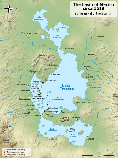
English: Map of the basin of Mexico circa 1519, at the arrival of the Spanish.
Español: Mapa de la cuenca de México acerca 1519, a la llegada de los españoles
Français : Carte du bassin de Mexico vers 1519, à l'arrivée des Espagnols. |
| Dagsetning | (UTC) |
| Uppruni |
|
| Höfundarréttarhafi |
|
| Aðrar útgáfur |
[]
|
| SVG genesis |


| Camera location | | View this and other nearby images on: OpenStreetMap |
|---|
Leyfisupplýsingar:
I, the copyright holder of this work, hereby publish it under the following licenses:
| Copyleft: This work of art is free; you can redistribute it and/or modify it according to terms of the Free Art License. You will find a specimen of this license on the Copyleft Attitude site as well as on other sites. |
This file is licensed under the Creative Commons Attribution-Share Alike 4.0 International, 3.0 Unported, 2.5 Generic, 2.0 Generic and 1.0 Generic license.
- Þér er frjálst:
- að deila – að afrita, deila og yfirfæra verkið
- að blanda – að breyta verkinu
- Undir eftirfarandi skilmálum:
- tilvísun höfundarréttar – Þú verður að tilgreina viðurkenningu á höfundarréttindum, gefa upp tengil á notkunarleyfið og gefa til kynna ef breytingar hafa verið gerðar. Þú getur gert þetta á einhvern ásættanlegan máta, en ekki á nokkurn þann hátt sem bendi til þess að leyfisveitandinn styðji þig eða notkun þína á verkinu.
- Deila eins – Ef þú breytir, yfirfærir eða byggir á þessu efni, þá mátt þú eingöngu dreifa því verki með sama eða svipuðu leyfi og upprunalega verkið er með.
Þú mátt velja notkunarleyfi að eigin vali.
Original upload log
This image is a derivative work of the following images:
- File:Lago_de_Texcoco-posclásico.png licensed with PD-self, PD-self/fr
- 2006-09-19T01:46:06Z Yavidaxiu 1412x1644 (344123 Bytes) {{Information |Description={{es|Mapa de la cuenca de México a la llegada de los españoles}} |Source=Trabajo propio |Date=18 de septiembre de 2006 |Author=Yavidaxiu |Permission={{PD-self}} |other_versions= }} [[Category:Map
- File:Valley_of_Mexico_c.1519-fr.svg licensed with Cc-by-sa-2.5,2.0,1.0, Cc-by-sa-3.0-migrated, GFDL
- 2007-09-11T14:00:14Z Historicair 731x849 (270643 Bytes)
- 2007-09-11T13:51:30Z Historicair 731x849 (272818 Bytes) {{Information |Description={{fr|Les environs de Tenochtitlan vers 1519}} {{en|Valley of Mexico circa 1519}} |Source=Own work |Date=11/09/2007 |Author=~~~~ |Permission={{self2|GFDL|cc-by-sa-2.5,2.0,1.0}} |other_versions= }} {{
Uploaded with derivativeFX
Breytingaskrá skjals
Smelltu á dagsetningu eða tímasetningu til að sjá hvernig hún leit þá út.
| Dagsetning/Tími | Smámynd | Víddir | Notandi | Athugasemd | |
|---|---|---|---|---|---|
| núverandi | 28. janúar 2021 kl. 20:29 | | 1.412 × 1.883 (526 KB) | Sémhur | Huexotla <=> Coatlinchán |
| 17. júlí 2013 kl. 05:40 |  | 1.412 × 1.883 (525 KB) | Citypeek | Enlargement of the legenda in the upper right corner. | |
| 17. júlí 2013 kl. 05:33 |  | 1.412 × 1.883 (533 KB) | Citypeek | Corrected two errors. Valid SVG now. | |
| 8. febrúar 2010 kl. 18:37 |  | 1.412 × 1.883 (533 KB) | Sémhur | + relief and some improvements | |
| 31. janúar 2010 kl. 09:45 |  | 1.412 × 1.645 (99 KB) | Sémhur | == {{int:filedesc}} == {{Information |Description= {{en|Map of the basin of Mexico circa 1519, at the arrival of the Spanish.}} {{es|Mapa de la cuenca de México acerca 1519, a la llegada de los españoles}} {{fr|Carte du bassin de Mexico vers 1519, à l |
Skráartenglar
Það eru engar síður sem nota þessa skrá.
Altæk notkun skráar
Eftirfarandi wikar nota einnig þessa skrá:
- Notkun á azb.wikipedia.org
- Notkun á ba.wikipedia.org
- Notkun á br.wikipedia.org
- Notkun á de.wikipedia.org
- Notkun á en.wikipedia.org
- Aztecs
- Iztapalapa
- Lake Texcoco
- Valley of Mexico
- Aztec Empire
- Altiplano Cundiboyacense
- Tenayuca
- User:Kazkaskazkasako/Books/History
- User:Maunus/sandbox
- List of conflicts in Mexico
- Lake Zumpango
- Lake Tauca
- User:SomeGuyWhoRandomlyEdits/List of conflicts in Mexico
- Sierra de Guadalupe, Mexico
- Battle of Colhuacatonco
- Notkun á en.wikibooks.org
- Notkun á es.wikipedia.org
- Notkun á fi.wikibooks.org
- Notkun á hr.wikipedia.org
- Notkun á hy.wikipedia.org
- Notkun á id.wikipedia.org
- Notkun á ja.wikipedia.org
- Notkun á ka.wikipedia.org
- Notkun á la.wikipedia.org
- Notkun á nl.wikipedia.org
- Notkun á nv.wikipedia.org
- Notkun á pl.wikipedia.org
- Notkun á rue.wikipedia.org
- Notkun á ru.wikipedia.org
- Notkun á sv.wikipedia.org
- Notkun á ta.wikipedia.org
- Notkun á tr.wikipedia.org
- Notkun á vi.wikipedia.org