
Mynd:Alliances expansive Map.png
Upphafleg skrá (1.357 × 628 mynddílar, skráarstærð: 50 KB, MIME-gerð: image/png)

|
File:Large alliances.svg is a vector version of this file. It should be used in place of this PNG file when not inferior.
File:Alliances expansive Map.png → File:Large alliances.svg
For more information, see Help:SVG. |
 |
Transferred from en.wikipedia to Commons by Maksim.
Lýsing
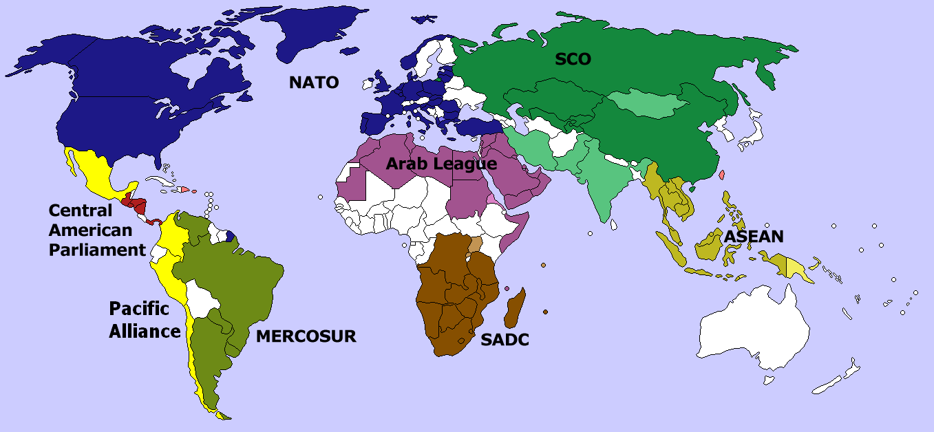
Map of several large international organizations/alliances. Darker colors indicate full membership. Softer colors indicate observer or candidate status. No overlap exists among the organizations shown above. Created by me, using Image:BlankMap-World-v4-colored.png. Aris Katsaris 22:43, 18 March 2006 (UTC)
Leyfisupplýsingar:

|
Gefið er leyfi til að afrita, dreifa og/eða breyta þessu skjali samkvæmt Frjálsa GNU Free Documentation License, útgáfu 1.2 eða nýrri, sem gefið er út af Frjálsu hugbúnaðarstofnuninni með engum breytingum þar á. Afrit af leyfinu er innifalið í kaflanum GNU Free Documentation License. |
| Þessi skrá er með Creative Commons Tilvísun-DeilaEins 3.0 Óstaðfært notkunarleyfi. | ||
| ||
| This licensing tag was added to this file as part of the GFDL licensing update. |
| date/time | username | edit summary |
|---|---|---|
| 22:43, 18 March 2006 | en:User:Aris Katsaris | (Map of several large international organizations/alliances. Darker colors indicate full membership. Softer colors indicate observer or candidate status. No overlap exists among the organizations shown above. Created by me, using [[:Image:BlankMap-World-v4) |
Original upload log
Legend: (cur) = this is the current file, (del) = delete this old version, (rev) = revert to this old version.
Click on date to download the file or see the image uploaded on that date.
- (del) (cur) 22:43, 18 March 2006 . . en:User:Aris_Katsaris Aris Katsaris ( en:User_talk:Aris_Katsaris Talk) . . 1357x628 (60865 bytes) (Map of several large international organizations/alliances. Darker colors indicate full membership. Softer colors indicate observer or candidate status. No overlap exists among the organizations shown above. Created by me, using [[:Image:BlankMap-World-v4)
Breytingaskrá skjals
Smelltu á dagsetningu eða tímasetningu til að sjá hvernig hún leit þá út.
| Dagsetning/Tími | Smámynd | Víddir | Notandi | Athugasemd | |
|---|---|---|---|---|---|
| núverandi | 4. apríl 2014 kl. 05:09 | | 1.357 × 628 (50 KB) | Capmo | addded Pacific Alliance, updated Mercosur |
| 10. ágúst 2011 kl. 22:18 |  | 1.357 × 628 (73 KB) | Hoshie | added South Sudan | |
| 9. mars 2008 kl. 08:28 |  | 1.357 × 628 (63 KB) | Hoshie | added Montenegro and Cabinda (Angola) | |
| 23. mars 2006 kl. 21:07 |  | 1.357 × 628 (59 KB) | Maksim | La bildo estas kopiita de wikipedia:en. La originala priskribo estas: == Summary == Map of several large international organizations/alliances. Darker colors indicate full membership. Softer colors indicate observer or candidate status. No overlap exists |
Skráartenglar
Það eru engar síður sem nota þessa skrá.
Altæk notkun skráar
Eftirfarandi wikar nota einnig þessa skrá:
- Notkun á ar.wikipedia.org
- Notkun á bg.wikipedia.org
- Notkun á de.wikipedia.org
- Notkun á en.wikipedia.org
- Notkun á eo.wikipedia.org
- Notkun á es.wikipedia.org
- Notkun á fa.wikipedia.org
- Notkun á hu.wikipedia.org
- Notkun á id.wikipedia.org
- Notkun á ja.wikipedia.org
- Notkun á kn.wikipedia.org
- Notkun á ms.wikipedia.org
- Notkun á pt.wikipedia.org
- Notkun á th.wikipedia.org
- Notkun á tr.wikipedia.org
- Notkun á vi.wikipedia.org