
Mynd:Tobago parishes.svg

Stærð þessarar PNG forskoðunar á SVG skránni: 800 × 550 mynddílar. Aðrar upplausnir: 320 × 220 mynddílar | 640 × 440 mynddílar | 1.024 × 703 mynddílar | 1.280 × 879 mynddílar | 2.560 × 1.759 mynddílar | 872 × 599 mynddílar.
Upphafleg skrá (SVG-skrá, að nafni til 872 × 599 mynddílar, skráarstærð: 155 KB)
Lýsing
| Lýsing |
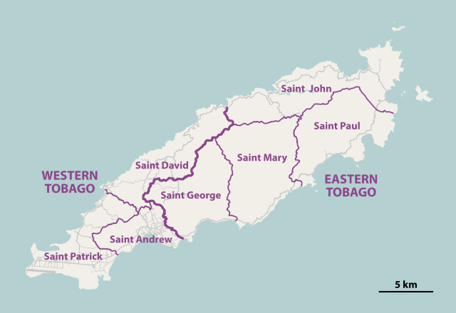
Deutsch: Karte der parishes von Tobago
English: Map of the parishes of Tobago |
||||||||||||
| Dagsetning | |||||||||||||
| Uppruni | http://tobagoborn.com/tobago/census/tobago_introv2.html | ||||||||||||
| Höfundarréttarhafi | NordNordWest | ||||||||||||
| Réttindi (Endurnotkun á þessari skrá) |
|
||||||||||||
| SVG genesis | This map was created with Adobe Illustrator by NordNordWest.
|

|
This map has been made or improved in the German Kartenwerkstatt (Map Lab). You can propose maps to improve as well.
|
Breytingaskrá skjals
Smelltu á dagsetningu eða tímasetningu til að sjá hvernig hún leit þá út.
| Dagsetning/Tími | Smámynd | Víddir | Notandi | Athugasemd | |
|---|---|---|---|---|---|
| núverandi | 8. janúar 2011 kl. 19:40 | | 872 × 599 (155 KB) | NordNordWest | =={{int:filedesc}}== {{Information |Description= {{de|Karte der ''parishes'' von Tobago}} {{en|Map of the parishes of Tobago}} |Source=http://tobagoborn.com/tobago/census/tobago_introv2.html |Date=2011-01-08 |Author={{U|Nord |
Skráartenglar
Eftirfarandi síða notar þessa skrá:
Altæk notkun skráar
Eftirfarandi wikar nota einnig þessa skrá:
- Notkun á ar.wikipedia.org
- Notkun á ca.wikipedia.org
- Notkun á cs.wikipedia.org
- Notkun á cv.wikipedia.org
- Notkun á de.wikipedia.org
- Notkun á en.wikipedia.org
- Notkun á es.wikipedia.org
- Notkun á eu.wikipedia.org
- Notkun á fa.wikipedia.org
- Notkun á fi.wiktionary.org
- Notkun á ga.wikipedia.org
- Notkun á ha.wikipedia.org
- Notkun á hr.wikipedia.org
- Notkun á id.wikipedia.org
- Notkun á it.wikivoyage.org
- Notkun á ja.wikipedia.org
- Notkun á ka.wikipedia.org
- Notkun á ko.wikipedia.org
- Notkun á mt.wikipedia.org
- Notkun á pl.wikipedia.org
- Notkun á ro.wikipedia.org
- Notkun á ru.wikipedia.org
- Notkun á sco.wikipedia.org
- Notkun á sh.wikipedia.org
- Notkun á sr.wikipedia.org
- Notkun á tr.wikipedia.org
- Notkun á uk.wikipedia.org
- Notkun á ur.wikipedia.org
- Notkun á war.wikipedia.org
- Notkun á www.wikidata.org
- Notkun á zh.wikipedia.org