
Mynd:Møns Klint 5.jpg

Upphafleg skrá (2.387 × 1.690 mynddílar, skráarstærð: 2,45 MB, MIME-gerð: image/jpeg)
Lýsing
| Lýsing |
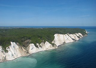
Deutsch: Ein Luftfoto von Møns Klint in Dänemark. In der Mitte sieht man Maglevands Fald mit Dronningestolen rechts. English: An aerial photo of Møns Klint (the Cliffs of Møn) in Denmark. Maglevands Fald is seen in the middle, with Dronningestolen on the right. |
||||
| Dagsetning | |||||
| Uppruni | eigin skrá | ||||
| Höfundarréttarhafi | Bob Collowan | ||||
| Réttindi (Endurnotkun á þessari skrá) |
|
||||

| Object location | | View this and other nearby images on: OpenStreetMap |
|---|
Leyfisupplýsingar:
- Þér er frjálst:
- að deila – að afrita, deila og yfirfæra verkið
- að blanda – að breyta verkinu
- Undir eftirfarandi skilmálum:
- tilvísun höfundarréttar – Þú verður að tilgreina viðurkenningu á höfundarréttindum, gefa upp tengil á notkunarleyfið og gefa til kynna ef breytingar hafa verið gerðar. Þú getur gert þetta á einhvern ásættanlegan máta, en ekki á nokkurn þann hátt sem bendi til þess að leyfisveitandinn styðji þig eða notkun þína á verkinu.
- Deila eins – Ef þú breytir, yfirfærir eða byggir á þessu efni, þá mátt þú eingöngu dreifa því verki með sama eða svipuðu leyfi og upprunalega verkið er með.
| Annotations | This image is annotated: View the annotations at Commons |

|
This is one of the images forming part of the Valued image set: Møns Klint (the Cliffs of Møn) on Wikimedia Commons. The image set has been assessed under the valued image set criteria and is considered the most valued set on Commons within the scope:
Møns Klint (the Cliffs of Møn)
You can see its nomination at Commons:Valued image candidates/Møns Klint. |
Breytingaskrá skjals
Smelltu á dagsetningu eða tímasetningu til að sjá hvernig hún leit þá út.
| Dagsetning/Tími | Smámynd | Víddir | Notandi | Athugasemd | |
|---|---|---|---|---|---|
| núverandi | 21. júní 2014 kl. 16:10 | | 2.387 × 1.690 (2,45 MB) | Bob Collowân | Straightened horizon |
| 4. júlí 2013 kl. 11:35 |  | 2.386 × 1.578 (2,5 MB) | Bob Collowân | User created page with UploadWizard |
Skráartenglar
Eftirfarandi síða notar þessa skrá:
Altæk notkun skráar
Eftirfarandi wikar nota einnig þessa skrá:
- Notkun á cs.wikipedia.org
- Notkun á da.wikipedia.org
- Notkun á de.wikivoyage.org
- Notkun á en.wikipedia.org
- Notkun á ko.wikipedia.org
- Notkun á lv.wikipedia.org
- Notkun á pl.wikivoyage.org
- Notkun á pt.wikipedia.org
- Notkun á th.wikipedia.org