
Mynd:Location Belgium EU Europe.png

Stærð þessarar forskoðunar: 721 × 600 mynddílar Aðrar upplausnir: 289 × 240 mynddílar | 577 × 480 mynddílar | 923 × 768 mynddílar | 1.231 × 1.024 mynddílar | 2.056 × 1.710 mynddílar.
Upphafleg skrá (2.056 × 1.710 mynddílar, skráarstærð: 176 KB, MIME-gerð: image/png)

|
File:EU-Belgium.svg is a vector version of this file. It should be used in place of this PNG file when not inferior.
File:Location Belgium EU Europe.png → File:EU-Belgium.svg
For more information, see Help:SVG. |
 |
Lýsing
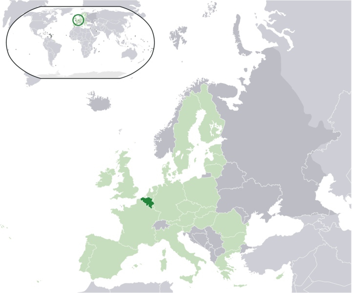
| Lýsing | Location map: Belgium (dark green) / European Union (light green) / Europe (dark grey); inspired by and consistent with general country locator maps by User:Vardion, et al. |
| Dagsetning | |
| Uppruni | eigin skrá |
| Höfundarréttarhafi | Quizimodo |
| Aðrar útgáfur |
|


Leyfisupplýsingar:
| This work has been released into the public domain by its author, I, Quizimodo. This applies worldwide. In some countries this may not be legally possible; if so: I, Quizimodo grants anyone the right to use this work for any purpose, without any conditions, unless such conditions are required by law. |
Breytingaskrá skjals
Smelltu á dagsetningu eða tímasetningu til að sjá hvernig hún leit þá út.
| Dagsetning/Tími | Smámynd | Víddir | Notandi | Athugasemd | |
|---|---|---|---|---|---|
| núverandi | 17. júní 2007 kl. 19:20 | | 2.056 × 1.710 (176 KB) | Quizimodo~commonswiki | image (updated) |
| 17. júní 2007 kl. 09:35 |  | 2.056 × 1.710 (226 KB) | Quizimodo~commonswiki | image (tweaked) | |
| 17. júní 2007 kl. 08:40 |  | 2.056 × 1.710 (226 KB) | Quizimodo~commonswiki | {{Information |Description=Location map: Belgium (dark green) / European Union (light green) / Europe (dark grey); inspired by and consistent with general country locator maps by User:Vardion, et al |Source=self-made |Date=17 June 2007 |Author= [[User:Qui |
Skráartenglar
Eftirfarandi síða notar þessa skrá:
Altæk notkun skráar
Eftirfarandi wikar nota einnig þessa skrá:
- Notkun á an.wikipedia.org
- Notkun á az.wiktionary.org
- Notkun á dz.wikipedia.org
- Notkun á eu.wiktionary.org
- Notkun á hif.wikipedia.org
- Notkun á kn.wikipedia.org
- Notkun á krc.wikipedia.org
- Notkun á lv.wikipedia.org
- Notkun á ms.wikipedia.org
- Notkun á pl.wiktionary.org
- Notkun á rue.wikipedia.org
- Notkun á sah.wikipedia.org
- Notkun á srn.wikipedia.org
- Notkun á su.wikipedia.org
- Notkun á tpi.wikipedia.org
- Notkun á ug.wikipedia.org