
Mynd:Isle of Man topographic map-en.svg

Stærð þessarar PNG forskoðunar á SVG skránni: 654 × 600 mynddílar. Aðrar upplausnir: 262 × 240 mynddílar | 524 × 480 mynddílar | 838 × 768 mynddílar | 1.117 × 1.024 mynddílar | 2.234 × 2.048 mynddílar | 1.200 × 1.100 mynddílar.
Upphafleg skrá (SVG-skrá, að nafni til 1.200 × 1.100 mynddílar, skráarstærð: 642 KB)

Lýsing
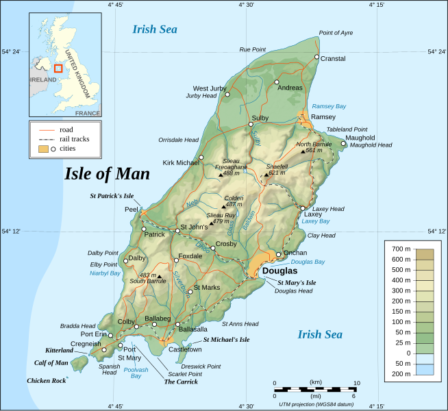
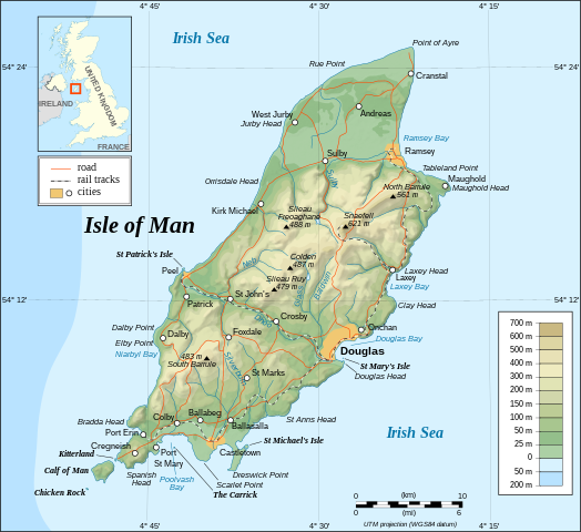
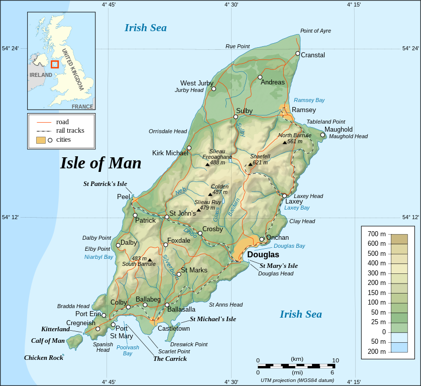
This image was selected as picture of the day on Wikimedia Commons for 26 November 2008. It was captioned as follows: English: Topographic map of the Isle of Man. Other languages:
Čeština: Topografická mapa Ostrova Man Dansk: Topografisk kort over Isle of Man. English: Topographic map of the Isle of Man. Français : Carte topographique en anglais de l'Île de Man. Íslenska: Staðfræðikort af eynni Mön. Italiano: Mappa topografica dell'Isola di Man. Magyar: Man sziget domborzati térképe Nederlands: Engelstalige topografische kaart van het Britse eiland Man Português: Mapa topográfico (em Inglês) da Ilha de Man. Română: Hartă topografică a Insulei Man Suomi: Mansaaren topografinen kartta. Svenska: Topografisk karta över Isle of Man. Русский: Топографическая карта Острова Мэн. 中文: 马恩岛地形图 中文(繁體): 曼島地形圖 |
|

| Lýsing |
English: Topographic map in English of the Isle of Man.
Note : The shaded relief is a raster image embedded in the SVG. Français : Carte topographique en anglais de l'Île de Man.
Note : Le relief ombré est une image bitmap embarquée dans le fichier SVG. Português: Mapa topográfico (em Inglês) da Ilha de Man.
Русский: Топографическая карта Острова Мэн на английском языке UTM projection; WGS84 datum; shaded relief (composite image of N-W, W and N lightning positions); |
||
| Dagsetning | |||
| Uppruni |
Own work ;
|
||
| Höfundarréttarhafi | Eric Gaba (Sting - fr:Sting) | ||
| Réttindi (Endurnotkun á þessari skrá) |
|
||
| Aðrar útgáfur |
Derivative works of this file: Isle of Man topographic map-ca.svg
[]
|


|
This SVG file contains embedded text that can be translated into your language, using any capable SVG editor, text editor or the SVG Translate tool. For more information see: About translating SVG files. |
Leyfisupplýsingar:
I, the copyright holder of this work, hereby publish it under the following licenses:

|
Gefið er leyfi til að afrita, dreifa og/eða breyta þessu skjali samkvæmt Frjálsa GNU Free Documentation License, útgáfu 1.2 eða nýrri, sem gefið er út af Frjálsu hugbúnaðarstofnuninni með engum breytingum þar á. Afrit af leyfinu er innifalið í kaflanum GNU Free Documentation License. |
| Þessi skrá er með Creative Commons Tilvísun-DeilaEins 3.0 Óstaðfært notkunarleyfi. | ||
| ||
| This licensing tag was added to this file as part of the GFDL licensing update. |
This file is licensed under the Creative Commons Attribution-Share Alike 2.5 Generic, 2.0 Generic and 1.0 Generic license.
- Þér er frjálst:
- að deila – að afrita, deila og yfirfæra verkið
- að blanda – að breyta verkinu
- Undir eftirfarandi skilmálum:
- tilvísun höfundarréttar – Þú verður að tilgreina viðurkenningu á höfundarréttindum, gefa upp tengil á notkunarleyfið og gefa til kynna ef breytingar hafa verið gerðar. Þú getur gert þetta á einhvern ásættanlegan máta, en ekki á nokkurn þann hátt sem bendi til þess að leyfisveitandinn styðji þig eða notkun þína á verkinu.
- Deila eins – Ef þú breytir, yfirfærir eða byggir á þessu efni, þá mátt þú eingöngu dreifa því verki með sama eða svipuðu leyfi og upprunalega verkið er með.
Þú mátt velja notkunarleyfi að eigin vali.
Breytingaskrá skjals
Smelltu á dagsetningu eða tímasetningu til að sjá hvernig hún leit þá út.
| Dagsetning/Tími | Smámynd | Víddir | Notandi | Athugasemd | |
|---|---|---|---|---|---|
| núverandi | 4. september 2008 kl. 13:40 | | 1.200 × 1.100 (642 KB) | Sting | New standard colors |
| 29. október 2007 kl. 23:19 |  | 1.200 × 1.100 (745 KB) | Sting | Some additional informations | |
| 21. maí 2007 kl. 20:55 |  | 1.200 × 1.100 (742 KB) | Sting | Some correction | |
| 21. maí 2007 kl. 18:24 |  | 1.200 × 1.100 (742 KB) | Sting | {{Information |Description=Topographic map in English of the Isle of Man |Source=Own work ;<br/>Topographic map : [http://www2.jpl.nasa.gov/srtm NASA Shuttle Radar Topography Mission] (SRTM3 v.2) (public domain) edited with [http://www |
Skráartenglar
Það eru engar síður sem nota þessa skrá.
Altæk notkun skráar
Eftirfarandi wikar nota einnig þessa skrá:
- Notkun á af.wikipedia.org
- Notkun á bn.wikipedia.org
- Notkun á cs.wikipedia.org
- Notkun á da.wikipedia.org
- Notkun á de.wikipedia.org
- Notkun á en.wikipedia.org
- Notkun á fi.wikipedia.org
- Notkun á fr.wikipedia.org
- Notkun á gv.wikipedia.org
- Notkun á hu.wikipedia.org
- Notkun á ko.wikipedia.org
- Notkun á nl.wikipedia.org
- Notkun á pl.wikipedia.org
- Notkun á pt.wikipedia.org
- Notkun á sc.wikipedia.org
- Notkun á simple.wikipedia.org
- Notkun á sk.wikipedia.org
- Notkun á sv.wikipedia.org
- Notkun á tr.wikipedia.org
- Notkun á uk.wikipedia.org
- Notkun á www.wikidata.org
- Notkun á zh.wikipedia.org