Mynd:Alnus incana range.svg

Page contents not supported in other languages.
Úr Wikipediu, frjálsa alfræðiritinu

Upphafleg skrá(SVG-skrá, að nafni til 2.232 × 797 mynddílar, skráarstærð: 5,33 MB)

Skrá þessi er af Wikimedia Commons, og deilt meðal annarra verkefna og nýtist því þar. Hér fyrir neðan er afrit af skráarsíðunni þar.

Lýsing

Lýsing
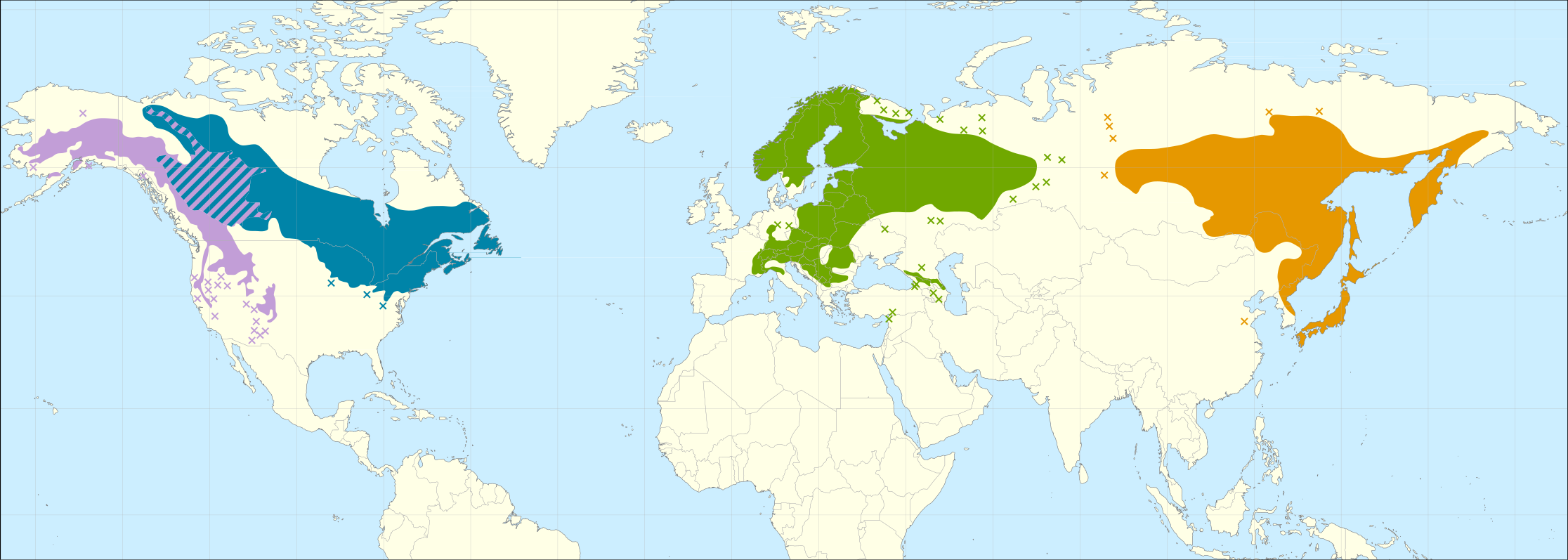
English: Distribution map of Alnus incana s.l. (Grey Alder).

Subspecies[1]:

     Alnus incana subsp. tenuifolia
     Alnus incana subsp. rugosa
     Alnus incana subsp. incana
     Alnus incana subsp. hirsuta

Included heterotypic synonyms:

  • Alnus incana subsp. tenuifolia: A. tenuifolia.
  • Alnus incana subsp. rugosa: A. rugosa.
  • Alnus incana subsp. incana: A. kolaensis.
  • Alnus incana subsp. hirsuta: A. hirsuta, A. tinctoria (treated as A. hirsuta by POWO).
Dagsetning
Uppruni

Caudullo, G., Welk, E., San-Miguel-Ayanz, J., 2017. Chorological maps for the main European woody species. Data in Brief 12, 662-666. DOI: 10.1016/j.dib.2017.05.007
Data: https://doi.org/10.6084/m9.figshare.5100727
References:

  • Botanical Society of Britain & Ireland. BSBI big database. Accessed in September 2016.
  • Fang, J., Wang, Z., Tang, Z. (Eds.), 2011. Atlas of Woody Plants in China. Springer Berlin Heidelberg, Berlin, Heidelberg.
  • GBIF.org, 2016. Artdata. DOI: 10.15468/dl.vhlsf9
  • GBIF.org, 2016. Botanical Society of the British Isles - Vascular Plants Database additions since 2000. DOI: 10.15468/dl.wzy04e
  • GBIF.org, 2016. Botanical Society of the British Isles - Vascular Plants Database. DOI: 10.15468/dl.c7xheb
  • GBIF.org, 2016. Dutch Vegetation Database (LVD). DOI: 10.15468/dl.km20zh
  • GBIF.org, 2016. Fieldjournal.org observation database. DOI: 10.15468/dl.qfbdxi
  • GBIF.org, 2016. FloVegSI - Floristical and fitocenological database of ZRC SAZU. DOI: 10.15468/dl.emozjq
  • GBIF.org, 2016. Flora von Deutschland (Phanerogamen). DOI: 10.15468/dl.jhwqco
  • GBIF.org, 2016. Florabank1 - A grid-based database on vascular plant distribution in the northern part of Belgium (Flanders and the Brussels Capital region). DOI: 10.15468/dl.t9ewq8
  • GBIF.org, 2016. Floristic Databases of Mecklenburg-Pomerania - Higher Plants. DOI: 10.15468/dl.ttbnoc
  • GBIF.org, 2016. Herbarium of Jyväskylä University Museum. DOI: 10.15468/dl.qlmmfd
  • GBIF.org, 2016. INPN - Données flore des CBN agrégées par la FCBN. DOI: 10.15468/dl.gkp7wm
  • GBIF.org, 2016. Institute of Dendrology PAS, Flora of Sudety Mountains. DOI: .15468/dl.kybkpr
  • GBIF.org, 2016. Karl Franzens University of Graz, Insitute for Botany - Herbarium GZU. DOI: 10.15468/dl.4ok78i
  • GBIF.org, 2016. National System of Protected Areas in Poland - Plants. DOI: 10.15468/dl.ym4vmn
  • GBIF.org, 2016. Norwegian Species Observation Service. DOI: 10.15468/dl.6domy8
  • GBIF.org, 2016. Occurrence Data of Vascular Plants collected or compiled for the Flora of Bavaria. DOI: 10.15468/dl.olxxvo
  • GBIF.org, 2016. Sistema de Información de la vegetación Ibérica y Macaronésica. DOI: 10.15468/dl.m8zdd8
  • GBIF.org, 2016. University of Vienna, Institute for Botany - Herbarium WU. DOI: 0.15468/dl.x5raqx
  • GBIF.org, 2016. Vascular plants in Denmark recorded under the The Nationwide Monitoring and Assessment Programme for the Aquatic and Terrestrial Environments (NOVANA). DOI: 10.15468/dl.hnqokh
  • Grossgeim, A. A., 1945. Flora of Caucasus Vol 3. Academy of Sciences of the USSR, Azerbaijan branch. Baku (In Russian)
  • Hultén, E., 1971. Atlas över växternas utbredning i Norden, 2nd edition. Generalstabens litografiska anstalts förlag, Stockholm.
  • Hultén, E., Fries, M., 1986. Atlas of North European vascular plants (North of the Tropic of Cancer), Vols. I-III. Koeltz scientific books. ISBN 3874292630
  • Jalas, J., Suominen, J.(Eds.), 1976. Atlas Florae Europaeae: distribution of vascular plants in Europe Vol. 3 Salicaceae to Balanophoraceae. Committee for Mapping the Flora of Europe and Societas Biologica Fennica Vanario, Helsinki.
  • Little, E.L., Jr., 1976. Atlas of United States trees, volume 3, minor Western hardwoods. U.S. Department of Agriculture Miscellaneous Publication 1314.
  • Little, E.L., Jr., 1977. Atlas of United States trees, volume 4, minor Eastern hardwoods. U.S. Department of Agriculture Miscellaneous Publication 1342.
  • Meusel, H., Jäger, E. J., Weinert, E. (Eds.), 1965. Vergleichende Chorologie der Zentraleuropäischen Flora, Band I. Gustav Fischer Verlag, Jena.
  • NetPhyD: Deutschlandflora WebGIS. Floristische Verbreitungskarten in Deutschland. Accessed in September 2016.
  • Nikolić, T. (Ed.), 2015. Flora Croatica Database. Faculty of Science, University of Zagreb. Accessed in September 2016.
  • Sokolov S. I., Svjaseva O. A., Kubli V. A., 1977. Areas of distribution of trees and shrubs in the USSR, vol 1. Nauka, Leningrad. (In Russian)
  • Tela Botanica. eFlore. Accessed in September 2016.
Höfundarréttarhafi Giovanni Caudullo

Leyfisupplýsingar:

I, the copyright holder of this work, hereby publish it under the following license:
w:en:Creative Commons
tilvísun höfundarréttar
This file is licensed under the Creative Commons Attribution 4.0 International license.
Þér er frjálst:
  • að deila – að afrita, deila og yfirfæra verkið
  • að blanda – að breyta verkinu
Undir eftirfarandi skilmálum:
  • tilvísun höfundarréttar – Þú verður að tilgreina viðurkenningu á höfundarréttindum, gefa upp tengil á notkunarleyfið og gefa til kynna ef breytingar hafa verið gerðar. Þú getur gert þetta á einhvern ásættanlegan máta, en ekki á nokkurn þann hátt sem bendi til þess að leyfisveitandinn styðji þig eða notkun þína á verkinu.

References

  1. Hultén, E; Fries, M (1986) Atlas of North European vascular plants (North of the Tropic of Cancer), Vols. I-III, Koeltz scientific books ISBN: 3874292630.

Captions

Add a one-line explanation of what this file represents

Items portrayed in this file

depicts enska

20. júlí 2016

media type enska

image/svg+xml

checksum enska

a842ff53efe6f22522c145dd23194884b4919de6

data size enska

5.589.857 Bæti

797 díll

2.232 díll

Breytingaskrá skjals

Smelltu á dagsetningu eða tímasetningu til að sjá hvernig hún leit þá út.

Dagsetning/TímiSmámyndVíddirNotandiAthugasemd
núverandi14. september 2016 kl. 13:37Smámynd útgáfunnar frá 14. september 2016, kl. 13:372.232 × 797 (5,33 MB)Giovanni CaudulloUpdated map in Europe with new references, removed legend
20. júlí 2016 kl. 13:46Smámynd útgáfunnar frá 20. júlí 2016, kl. 13:461.240 × 460 (5,56 MB)Giovanni CaudulloFont render problems
20. júlí 2016 kl. 13:39Smámynd útgáfunnar frá 20. júlí 2016, kl. 13:391.240 × 460 (5,56 MB)Giovanni CaudulloFont render problems
20. júlí 2016 kl. 13:38Smámynd útgáfunnar frá 20. júlí 2016, kl. 13:381.240 × 460 (5,56 MB)Giovanni CaudulloReverted to version as of 13:33, 20 July 2016 (UTC)
20. júlí 2016 kl. 13:37Smámynd útgáfunnar frá 20. júlí 2016, kl. 13:371.240 × 460 (5,56 MB)Giovanni CaudulloFont render problems
20. júlí 2016 kl. 13:33Smámynd útgáfunnar frá 20. júlí 2016, kl. 13:331.240 × 460 (5,56 MB)Giovanni CaudulloFont render problems
20. júlí 2016 kl. 12:58Smámynd útgáfunnar frá 20. júlí 2016, kl. 12:581.240 × 460 (5,56 MB)Giovanni CaudulloFont visualization
20. júlí 2016 kl. 12:54Smámynd útgáfunnar frá 20. júlí 2016, kl. 12:541.240 × 460 (5,56 MB)Giovanni CaudulloSmaller font
20. júlí 2016 kl. 12:51Smámynd útgáfunnar frá 20. júlí 2016, kl. 12:511.240 × 460 (5,56 MB)Giovanni CaudulloFixed fonts problems
20. júlí 2016 kl. 12:37Smámynd útgáfunnar frá 20. júlí 2016, kl. 12:371.240 × 460 (5,31 MB)Giovanni CaudulloUser created page with UploadWizard

Eftirfarandi 4 síður nota þessa skrá:

Altæk notkun skráar

Eftirfarandi wikar nota einnig þessa skrá:

Lýsigögn