
Mynd:1918 Flu pandemic-en.svg

Stærð þessarar PNG forskoðunar á SVG skránni: 560 × 375 mynddílar. Aðrar upplausnir: 320 × 214 mynddílar | 640 × 429 mynddílar | 1.024 × 686 mynddílar | 1.280 × 857 mynddílar | 2.560 × 1.714 mynddílar.
Upphafleg skrá (SVG-skrá, að nafni til 560 × 375 mynddílar, skráarstærð: 224 KB)
Lýsing
| Lýsing |
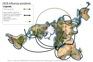
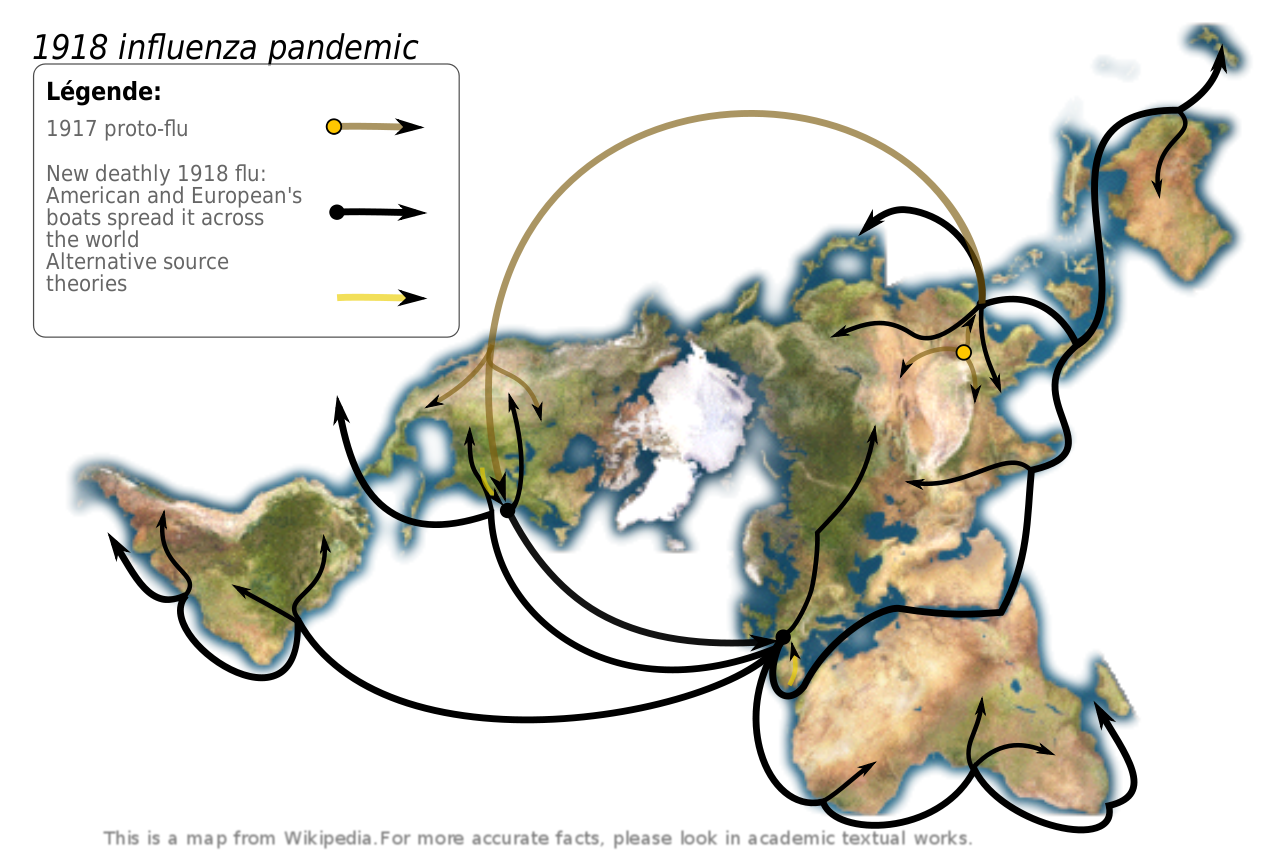
Map showing the 1918 Flu pandemic. Made according to Institut pasteur's data, graphism made by myself. Sources:
Pr. Hannoun being one of the world leading experts of the 1918 influenza, and the Institut Pasteur leading expert. In his paper, he support the Chinese origin, but also notice other theories.
|
||
| Dagsetning | (UTC) | ||
| Uppruni | |||
| Höfundarréttarhafi |
|
||
| SVG genesis |
|
Leyfisupplýsingar:
Þessi skrá er með Creative Commons Tilvísun-DeilaEins 3.0 Óstaðfært notkunarleyfi.
- Þér er frjálst:
- að deila – að afrita, deila og yfirfæra verkið
- að blanda – að breyta verkinu
- Undir eftirfarandi skilmálum:
- tilvísun höfundarréttar – Þú verður að tilgreina viðurkenningu á höfundarréttindum, gefa upp tengil á notkunarleyfið og gefa til kynna ef breytingar hafa verið gerðar. Þú getur gert þetta á einhvern ásættanlegan máta, en ekki á nokkurn þann hátt sem bendi til þess að leyfisveitandinn styðji þig eða notkun þína á verkinu.
- Deila eins – Ef þú breytir, yfirfærir eða byggir á þessu efni, þá mátt þú eingöngu dreifa því verki með sama eða svipuðu leyfi og upprunalega verkið er með.
Original upload log
This image is a derivative work of the following images:
- Image:Dymaxion_map_unfolded-no-ocean.png licensed with PD-self
- 2005-08-28T12:36:31Z Rhythm 638x365 (137983 Bytes) this image may be subsitude by this other bigger one [[Image:Dymaxion continents.jpg|thumb]] ==Description== This is an unfolded [[dymaxion map]], unfolded to show the land-masses of the world as nearly continuous. This is a
Uploaded with derivativeFX
Breytingaskrá skjals
Smelltu á dagsetningu eða tímasetningu til að sjá hvernig hún leit þá út.
| Dagsetning/Tími | Smámynd | Víddir | Notandi | Athugasemd | |
|---|---|---|---|---|---|
| núverandi | 1. maí 2009 kl. 14:15 | | 560 × 375 (224 KB) | Yug | improvement : legend, colors, crop. |
| 26. júlí 2008 kl. 01:00 |  | 638 × 365 (257 KB) | Yug | image size restored | |
| 26. júlí 2008 kl. 00:56 |  | 638 × 365 (255 KB) | Yug | fix arrow bugs... putain j'en chie ! | |
| 26. júlí 2008 kl. 00:42 |  | 638 × 365 (221 KB) | Yug | try again after sudo apt-get install python-lxml | |
| 26. júlí 2008 kl. 00:34 |  | 638 × 365 (40 KB) | Yug | Try to avoid the embeded image bug | |
| 26. júlí 2008 kl. 00:30 |  | 638 × 365 (40 KB) | Yug | {{Information |Description=Map showing the 1918 Flu pandemic. Data from personal research (source : Intitut pasteur), graphism made by myself. ;Derivate from Image:Dymaxion_map_unfolded-no-ocean.png This image may be substituted by this other bigger |
Skráartenglar
Eftirfarandi síða notar þessa skrá:
Altæk notkun skráar
Eftirfarandi wikar nota einnig þessa skrá:
- Notkun á en.wikipedia.org
- Notkun á en.wikiquote.org
- Notkun á hu.wikipedia.org
- Notkun á ln.wikipedia.org
- Notkun á mk.wikipedia.org