
Mynd:Xi'an location.png
Það er engin hærri upplausn til.
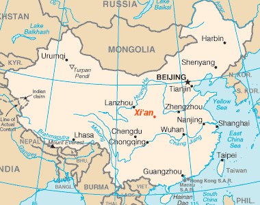
Xi'an_location.png (380 × 300 mynddílar, skráarstærð: 19 KB, MIME-gerð: image/png)
Location of the town Xi'an
cropped, one point added

|
This map image could be re-created using vector graphics as an SVG file. This has several advantages; see Commons:Media for cleanup for more information. If an SVG form of this image is available, please upload it and afterwards replace this template with
{{vector version available|new image name}}.
It is recommended to name the SVG file “Xi'an location.svg”—then the template Vector version available (or Vva) does not need the new image name parameter. |
This image is in the public domain because it contains materials that originally came from the United States Central Intelligence Agency's World Factbook.
|
 |
Breytingaskrá skjals
Smelltu á dagsetningu eða tímasetningu til að sjá hvernig hún leit þá út.
| Dagsetning/Tími | Smámynd | Víddir | Notandi | Athugasemd | |
|---|---|---|---|---|---|
| núverandi | 15. september 2005 kl. 08:20 | | 380 × 300 (19 KB) | Kreusch~commonswiki | Location of the town Xi'an cropped, one point added Category:Locator_maps_of_cities_in_China {{PD-USGov-CIA-WF}} |
Skráartenglar
Það eru engar síður sem nota þessa skrá.
Altæk notkun skráar
Eftirfarandi wikar nota einnig þessa skrá:
- Notkun á ba.wikipedia.org
- Notkun á en.wikipedia.org
- Notkun á et.wikipedia.org
- Notkun á fa.wikipedia.org
- Notkun á fr.wikipedia.org
- Notkun á fr.wiktionary.org
- Notkun á hr.wikipedia.org
- Notkun á ja.wikipedia.org
- Notkun á ko.wikipedia.org
- Notkun á ru.wikipedia.org
- Notkun á sh.wikipedia.org
- Notkun á sl.wikipedia.org
- Notkun á tr.wikipedia.org