
Mynd:Taxodium mucronatum range map.png
Stærð þessarar forskoðunar: 795 × 600 mynddílar Aðrar upplausnir: 318 × 240 mynddílar | 636 × 480 mynddílar | 908 × 685 mynddílar.
Upphafleg skrá (908 × 685 mynddílar, skráarstærð: 61 KB, MIME-gerð: image/png)
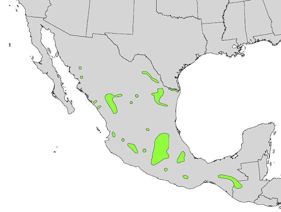
Lýsing
| Lýsing |
English: Range distribution map of Taxodium mucronatum — Montezuma cypress, in North America. |
|||
| Dagsetning | ||||
| Uppruni | Digital representation of "Atlas of United States Trees" by Elbert L. Little, Jr. [1] | |||
| Höfundarréttarhafi | U.S. Geological Survey | |||
| Réttindi (Endurnotkun á þessari skrá) |
|
Leyfisupplýsingar:
This work is in the public domain in the United States because it is a work prepared by an officer or employee of the United States Government as part of that person’s official duties under the terms of Title 17, Chapter 1, Section 105 of the US Code.
Note: This only applies to original works of the Federal Government and not to the work of any individual U.S. state, territory, commonwealth, county, municipality, or any other subdivision. This template also does not apply to postage stamp designs published by the United States Postal Service since 1978. (See § 313.6(C)(1) of Compendium of U.S. Copyright Office Practices). It also does not apply to certain US coins; see The US Mint Terms of Use.
|
 | |
| This file has been identified as being free of known restrictions under copyright law, including all related and neighboring rights. | ||
Breytingaskrá skjals
Smelltu á dagsetningu eða tímasetningu til að sjá hvernig hún leit þá út.
| Dagsetning/Tími | Smámynd | Víddir | Notandi | Athugasemd | |
|---|---|---|---|---|---|
| núverandi | 22. desember 2012 kl. 00:10 | | 908 × 685 (61 KB) | MPF | cleanup |
| 11. október 2012 kl. 14:17 |  | 908 × 712 (102 KB) | Pinethicket | {{Information |Description ={{en|1=Range map of ''Taxodium mucronatum'' }} |Source =Digital representation of "Atlas of United States Trees" by Elbert L. Little, Jr. [http://esp.cr.usgs.gov/data/atlas/little/] |Author =U.S. Geologica... |
Skráartenglar
Eftirfarandi síða notar þessa skrá:
Altæk notkun skráar
Eftirfarandi wikar nota einnig þessa skrá:
- Notkun á arz.wikipedia.org
- Notkun á bg.wikipedia.org
- Notkun á ceb.wikipedia.org
- Notkun á cs.wikipedia.org
- Notkun á en.wikipedia.org
- Notkun á eo.wikipedia.org
- Notkun á es.wikipedia.org
- Notkun á fa.wikipedia.org
- Notkun á fr.wikipedia.org
- Notkun á hu.wikipedia.org
- Notkun á it.wikipedia.org
- Notkun á ja.wikipedia.org
- Notkun á lt.wikipedia.org
- Notkun á no.wikipedia.org
- Notkun á pl.wikipedia.org
- Notkun á pt.wikipedia.org
- Notkun á ru.wikipedia.org
- Notkun á sv.wikipedia.org
- Notkun á uk.wikipedia.org
- Notkun á www.wikidata.org
- Notkun á zh.wikipedia.org