
Mynd:Sable island.jpg

Stærð þessarar forskoðunar: 598 × 600 mynddílar Aðrar upplausnir: 239 × 240 mynddílar | 637 × 639 mynddílar.
Upphafleg skrá (637 × 639 mynddílar, skráarstærð: 103 KB, MIME-gerð: image/jpeg)
Lýsing
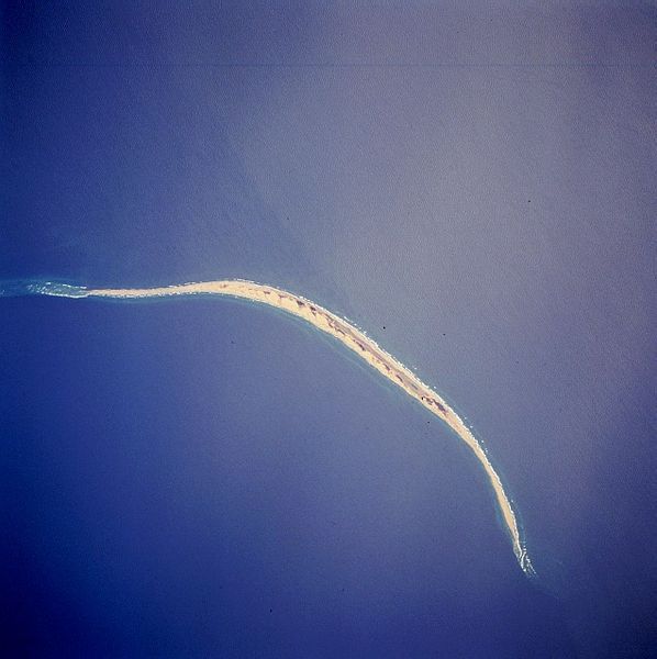
| Lýsing | Satellite image of Sable Island (Canada). STS059-216-079 Sable Island, Nova Scotia, Canada April 1994 Sable Island is a low sandy island approximately 25 miles (40 km) long and 1 mile (1.5 km) wide in the Atlantic Ocean. Located 115 miles (180 km) southeast of Cape Canso, Nova Scotia, the island is the exposed part of a sand shoal that extends northeast/southwest for more than 100 miles (160 km). Sable Island, known as the “graveyard of the Atlantic Ocean,” has been a major hazard to navigation. The island is also noted as a breeding ground for seals, which are protected by the Canadian government. The island helps to mark the western edge of the northeasterly flowing warm waters of the Gulf Stream. |
| Dagsetning | |
| Uppruni | eol.jsc.nasa.gov |
| Höfundarréttarhafi | NASA |
| Aðrar útgáfur | Derivative works of this file: Sable island-N.png |
This image or video was catalogued by one of the centers of the United States National Aeronautics and Space Administration (NASA) under Photo ID: STS059-216-079. This tag does not indicate the copyright status of the attached work. A normal copyright tag is still required. See Commons:Licensing. Other languages:
|
Leyfisupplýsingar:
| This file is in the public domain in the United States because it was solely created by NASA. NASA copyright policy states that "NASA material is not protected by copyright unless noted". (See Template:PD-USGov, NASA copyright policy page or JPL Image Use Policy.) | ||
 |
Warnings:
|
Breytingaskrá skjals
Smelltu á dagsetningu eða tímasetningu til að sjá hvernig hún leit þá út.
| Dagsetning/Tími | Smámynd | Víddir | Notandi | Athugasemd | |
|---|---|---|---|---|---|
| núverandi | 2. desember 2005 kl. 17:44 | | 637 × 639 (103 KB) | Islandspec~commonswiki | Satellite image of Sable Island (Canada). Source:English Wikipedia. |
Skráartenglar
Eftirfarandi síða notar þessa skrá:
Altæk notkun skráar
Eftirfarandi wikar nota einnig þessa skrá:
- Notkun á ar.wikipedia.org
- Notkun á arz.wikipedia.org
- Notkun á bg.wikipedia.org
- Notkun á ceb.wikipedia.org
- Notkun á de.wikipedia.org
- Notkun á de.wikivoyage.org
- Notkun á el.wikipedia.org
- Notkun á en.wikipedia.org
- Notkun á en.wikivoyage.org
- Notkun á eo.wikipedia.org
- Notkun á es.wikipedia.org
- Notkun á fr.wikivoyage.org
- Notkun á fy.wikipedia.org
- Notkun á he.wikipedia.org
- Notkun á it.wikipedia.org
- Notkun á ja.wikipedia.org
- Notkun á ko.wikipedia.org
- Notkun á nl.wikipedia.org
- Notkun á no.wikipedia.org
- Notkun á pt.wikipedia.org
- Notkun á ru.wikipedia.org
- Notkun á sv.wikipedia.org
- Notkun á uk.wikipedia.org
- Notkun á ur.wikipedia.org
- Notkun á www.wikidata.org
- Notkun á zh.wikipedia.org