
Mynd:Pyrenees topographic map-en.svg

Stærð þessarar PNG forskoðunar á SVG skránni: 800 × 475 mynddílar. Aðrar upplausnir: 320 × 190 mynddílar | 640 × 380 mynddílar | 1.024 × 608 mynddílar | 1.280 × 760 mynddílar | 2.560 × 1.520 mynddílar | 3.200 × 1.900 mynddílar.
Upphafleg skrá (SVG-skrá, að nafni til 3.200 × 1.900 mynddílar, skráarstærð: 6,3 MB)
| Lýsing |
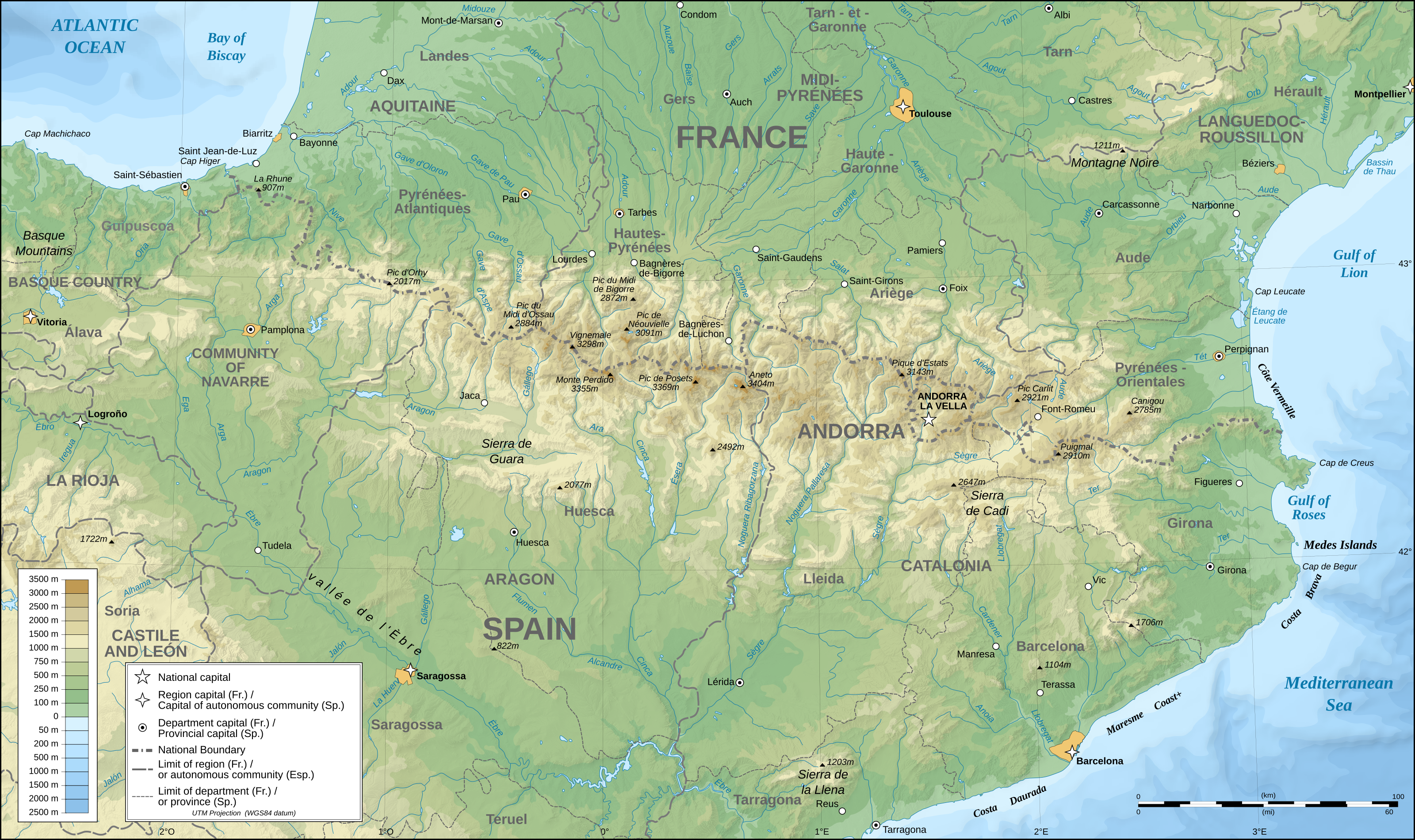
English: Topographic map in English of the Pyrenees Mountains. Note: The shaded relief is a raster image embedded in the SVG file. Français : Carte topographique des Pyrénées en english.
UTM projection; WGS84 datum; shaded relief (composite image of N-W, W and N lightning positions);Note : Le relief ombré est une image bitmap embarquée dans le fichier SVG. *The approximate horizontal accuracy of topographic data and shore/lakes limits is 1,125 m (per pixel). This map should not be printed over a 1:1 ratio (27.09 x 16.09cm), which corresponds to a scale of 1:2,010,221. *Approximate scale of the bathymetry: 1:7,708,000 (precision: 1,927 m) |
| Dagsetning | (UTC) |
| Uppruni | |
| Höfundarréttarhafi |
|
| This is a retouched picture, which means that it has been digitally altered from its original version. Modifications: translation into English. The original can be viewed here: Pyrenees topographic map-fr.svg:
|
I, the copyright holder of this work, hereby publish it under the following licenses:
This file is licensed under the Creative Commons Attribution-Share Alike 2.5 Generic, 2.0 Generic and 1.0 Generic license.
- Þér er frjálst:
- að deila – að afrita, deila og yfirfæra verkið
- að blanda – að breyta verkinu
- Undir eftirfarandi skilmálum:
- tilvísun höfundarréttar – Þú verður að tilgreina viðurkenningu á höfundarréttindum, gefa upp tengil á notkunarleyfið og gefa til kynna ef breytingar hafa verið gerðar. Þú getur gert þetta á einhvern ásættanlegan máta, en ekki á nokkurn þann hátt sem bendi til þess að leyfisveitandinn styðji þig eða notkun þína á verkinu.
- Deila eins – Ef þú breytir, yfirfærir eða byggir á þessu efni, þá mátt þú eingöngu dreifa því verki með sama eða svipuðu leyfi og upprunalega verkið er með.
| Þessi skrá er með Creative Commons Tilvísun-DeilaEins 3.0 Óstaðfært notkunarleyfi. | ||
| ||
| This licensing tag was added to this file as part of the GFDL licensing update. |

|
Gefið er leyfi til að afrita, dreifa og/eða breyta þessu skjali samkvæmt Frjálsa GNU Free Documentation License, útgáfu 1.2 eða nýrri, sem gefið er út af Frjálsu hugbúnaðarstofnuninni með engum breytingum þar á. Afrit af leyfinu er innifalið í kaflanum GNU Free Documentation License. |
Þú mátt velja notkunarleyfi að eigin vali.
Original upload log
This image is a derivative work of the following images:
- File:Pyrenees_topographic_map-fr.svg licensed with Cc-by-sa-2.5,2.0,1.0, Cc-by-sa-3.0-migrated, GFDL
- 2008-09-23T15:49:03Z Sting 3200x1900 (6608359 Bytes) Using ETOPO1 data for bathymetry; new standard colors
- 2007-07-02T00:25:17Z Sting 3200x1900 (6191391 Bytes) + projection info in key ; + major cities areas ; some corrections in the rivers
- 2007-06-25T20:30:25Z Sting 3200x1900 (6166321 Bytes) + key for borders
- 2007-05-31T21:18:03Z Sting 3200x1900 (6163256 Bytes) Some corrections
- 2007-05-30T18:23:51Z Sting 3200x1900 (6163275 Bytes) {{Information |Description=Topographic map in French of the [[:en:Pyrenees|Pyrenees mountains]] |Source=Own work ;Topographic map : [http://www2.jpl.nasa.gov/srtm NASA Shuttle Radar Topography Mission] (SRTM3 v.2) (public dom
Breytingaskrá skjals
Smelltu á dagsetningu eða tímasetningu til að sjá hvernig hún leit þá út.
| Dagsetning/Tími | Smámynd | Víddir | Notandi | Athugasemd | |
|---|---|---|---|---|---|
| núverandi | 28. maí 2011 kl. 00:25 | | 3.200 × 1.900 (6,3 MB) | RedWolf | {{Information |Description={{en|Topographic map in English of the Pyrenees mountains.<br/>''Note:'' The shaded relief is a raster image embedded in the SVG file.}} {{fr|Carte topographique des Pyrénées en english.<br/ |
Skráartenglar
Eftirfarandi síða notar þessa skrá:
Altæk notkun skráar
Eftirfarandi wikar nota einnig þessa skrá:
- Notkun á am.wikipedia.org
- Notkun á ar.wikipedia.org
- Notkun á bg.wikipedia.org
- Notkun á bh.wikipedia.org
- Notkun á bn.wikipedia.org
- Notkun á ca.wikipedia.org
- Notkun á ceb.wikipedia.org
- Notkun á cs.wikipedia.org
- Notkun á da.wikipedia.org
- Notkun á en.wikipedia.org
- Pyrenees
- Col du Tourmalet
- Canigou
- Aneto
- Pic du Midi de Bigorre
- Pre-Pyrenees
- Vignemale
- Monte Perdido
- Pic du Midi d'Ossau
- Montsec Range
- Larrun
- Pica d'Estats
- Col d'Aubisque
- Mallos de Riglos
- Collarada
- Pla d'Adet
- Mount Baigura
- Balaïtous
- Col d'Ares
- Col d'Aspin
- Pic Long
- Corbières Massif
- Hautza
- La Mongie
- Pic del Port Vell
- Pic de Sanfonts
- Port de Pailhères
- Port de Balès
- Col de Portet d'Aspet
- Col de Menté
- Col de Peyresourde
- Port de Larrau
- Col de Port
- Col de Marie-Blanque
- Puigmal
- Pic Ramougn
- Soum de Ramond
Skoða frekari altæka notkun þessarar skráar.