
Mynd:Printing towns incunabula.svg

Stærð þessarar PNG forskoðunar á SVG skránni: 554 × 600 mynddílar. Aðrar upplausnir: 222 × 240 mynddílar | 443 × 480 mynddílar | 709 × 768 mynddílar | 946 × 1.024 mynddílar | 1.892 × 2.048 mynddílar | 1.843 × 1.995 mynddílar.
Upphafleg skrá (SVG-skrá, að nafni til 1.843 × 1.995 mynddílar, skráarstærð: 1,72 MB)
Lýsing
| Lýsing |
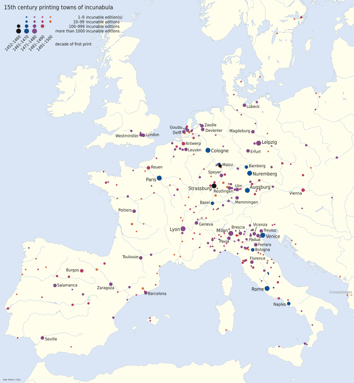
Deutsch: Verbreitung des Buchdrucks im 15. Jahrhundert dargestellt anhand der Druckorte von Inkunabeln. 271 Druckorte sind bekannt, die größten sind mit Namen versehen. Die Daten beruhen auf dem Incunabula Short Title Catalogue der British Library (Stand 2. März 2011). Die Gewässerdarstellung entspricht dem heutigen Stand.
English: Printing places of incunabula showing the spread of printing in the 15th century. 271 locations are known, the largest of them are designated by name. The data is based on the Incunabula Short Title Catalogue of the British Library (as of March 2, 2011). Bodies of water correspond to present state.
Français : Diffusion de l'imprimerie au XVe siècle représentée par les lieux d'impression des incunables. 271 lieux d'impression sont connus, les plus grands ont des noms. Les données sont basées sur le Incunabula Short Title Catalogue de la British Library (au 2 mars 2011). La représentation de l'eau correspond à l'état actuel.
Español: Difusión de la imprenta en el siglo XV representada por los lugares de imprenta de incunables. Se conocen 271 lugares de imprenta en el siglo XV, las más grandes tienen nombres. Los datos se basan en el Incunabula Short Title Catalogue de la British Library (a partir del 2 de marzo de 2011). La representación del agua corresponde al estado actual. |
|
| Dagsetning | ||
| Uppruni | eigin skrá | |
| Höfundarréttarhafi | NordNordWest | |
| Réttindi (Endurnotkun á þessari skrá) |
This file is licensed under the Creative Commons Attribution-Share Alike 3.0 Germany license.
 Þessi skrá er með Creative Commons Tilvísun-DeilaEins 3.0 Óstaðfært notkunarleyfi.
|
|
| Aðrar útgáfur |
|


|
This map has been made or improved in the German Kartenwerkstatt (Map Lab). You can propose maps to improve as well.
|
Breytingaskrá skjals
Smelltu á dagsetningu eða tímasetningu til að sjá hvernig hún leit þá út.
| Dagsetning/Tími | Smámynd | Víddir | Notandi | Athugasemd | |
|---|---|---|---|---|---|
| núverandi | 4. september 2012 kl. 17:26 | | 1.843 × 1.995 (1,72 MB) | NordNordWest | upd |
| 21. júní 2012 kl. 09:47 |  | 1.843 × 1.995 (1,7 MB) | Gun Powder Ma | Reverted to version as of 15:34, 4 September 2011 Cannot guarantee the accuracy of all 270 entries as the original creators have not been informed about the recreation of the map | |
| 3. apríl 2012 kl. 16:21 |  | 1.923 × 2.128 (1,06 MB) | Cxw | Recolored so five decades are more visually distinct; made labels larger. Removed lots of SVG data outside the viewport. Same license. | |
| 4. september 2011 kl. 15:34 |  | 1.843 × 1.995 (1,7 MB) | NordNordWest | c | |
| 4. september 2011 kl. 11:50 |  | 1.843 × 1.995 (1,7 MB) | NordNordWest | corr | |
| 30. ágúst 2011 kl. 18:57 |  | 1.843 × 1.995 (1,71 MB) | NordNordWest | == {{int:filedesc}} == {{Information |Description= {{de|Verbreitung des Buchdrucks im 15. Jahrhundert: Die Karte zeigt die Druckorte von Inkunabeln. Die Daten beruhen auf dem [http://www.bl.uk/catalogues/istc/ ''Incunabula Short Title Ca |
Skráartenglar
Eftirfarandi síða notar þessa skrá:
Altæk notkun skráar
Eftirfarandi wikar nota einnig þessa skrá:
- Notkun á an.wikipedia.org
- Notkun á ar.wikipedia.org
- Notkun á ast.wikipedia.org
- Notkun á bg.wikipedia.org
- Notkun á bs.wikipedia.org
- Notkun á ca.wikipedia.org
- Notkun á co.wikipedia.org
- Notkun á cs.wikipedia.org
- Notkun á de.wikipedia.org
- Notkun á el.wikipedia.org
- Notkun á en.wikipedia.org
- Notkun á es.wikipedia.org
- Notkun á eu.wikipedia.org
- Notkun á fr.wikipedia.org
- Imprimerie
- Johannes Gutenberg
- Incunable
- Chronologie de la presse
- Renaissance
- Histoire de l'imprimerie en Bretagne
- Histoire de l'imprimerie en Mayenne
- Histoire de l'imprimerie à Lyon
- Presse typographique
- Lyon à la Renaissance
- Histoire de l'imprimerie à Château-Gontier
- Histoire de l'imprimerie à Laval (Mayenne)
- Utilisateur:Framorille/Brouillon2
- Manufactures royales en France
- Notkun á fr.wikibooks.org
- Notkun á fy.wikipedia.org
- Notkun á gl.wikipedia.org
- Notkun á he.wikipedia.org
- Notkun á hu.wikipedia.org
- Notkun á hy.wikipedia.org
Skoða frekari altæka notkun þessarar skráar.