
Mynd:Portuguese discoveries and explorationsV2en.png

Stærð þessarar forskoðunar: 800 × 370 mynddílar Aðrar upplausnir: 320 × 148 mynddílar | 640 × 296 mynddílar | 1.357 × 628 mynddílar.
Upphafleg skrá (1.357 × 628 mynddílar, skráarstærð: 213 KB, MIME-gerð: image/png)

|
This historical map image could be re-created using vector graphics as an SVG file. This has several advantages; see Commons:Media for cleanup for more information. If an SVG form of this image is available, please upload it and afterwards replace this template with
{{vector version available|new image name}}.
It is recommended to name the SVG file “Portuguese discoveries and explorationsV2en.svg”—then the template Vector version available (or Vva) does not need the new image name parameter. |
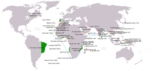
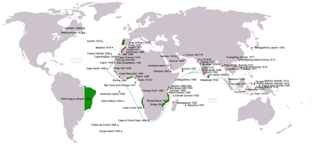
| Lýsing | Portuguese discoveries, exploration, contacts and conquests (from 1336 claim for Canary islands to 1543 Tanegashima arrival), arrival dates stated; main sea routes to the Indian Ocean (blue); Territories claimed under king John III of Portugal rule c.1536(green); English version |
| Dagsetning | (UTC) |
| Uppruni | |
| Höfundarréttarhafi | |
| Réttindi (Endurnotkun á þessari skrá) |
Creative Commons Attribution-Share Alike 3.0 Unported license |
| Aðrar útgáfur | (pt) File:Descobrimentos e explorações portuguesesV2.png |
| This is a retouched picture, which means that it has been digitally altered from its original version. Modifications: english version. The original can be viewed here: Descobrimentos e explorações portuguesesV2.png:
|
I, the copyright holder of this work, hereby publish it under the following license:

|
Gefið er leyfi til að afrita, dreifa og/eða breyta þessu skjali samkvæmt Frjálsa GNU Free Documentation License, útgáfu 1.2 eða nýrri, sem gefið er út af Frjálsu hugbúnaðarstofnuninni með engum breytingum þar á. Afrit af leyfinu er innifalið í kaflanum GNU Free Documentation License. |
| Þessi skrá er með Creative Commons Tilvísun-DeilaEins 3.0 Óstaðfært notkunarleyfi. | ||
| ||
| This licensing tag was added to this file as part of the GFDL licensing update. |
Original upload log
This image is a derivative work of the following images:
- File:Descobrimentos_e_explorações_portuguesesV2.png licensed with GFDL
- 2009-06-07T18:23:47Z Uxbona 1357x628 (209965 Bytes) Reverted to version as of 16:09, 7 June 2009
- 2009-06-07T18:21:32Z Uxbona 1357x628 (208814 Bytes) English version
- 2009-06-07T16:09:30Z Uxbona 1357x628 (209965 Bytes) {{Information |Description=Portuguese discoveries and explorations, sea routes |Source=*[[:File:Descobrimentos_e_explorações_portugueses.png|]] |Date=2009-06-07 17:07 (UTC) |Author=*[[:File:Descobrimentos_e_explorações_po
Uploaded with derivativeFX
Breytingaskrá skjals
Smelltu á dagsetningu eða tímasetningu til að sjá hvernig hún leit þá út.
| Dagsetning/Tími | Smámynd | Víddir | Notandi | Athugasemd | |
|---|---|---|---|---|---|
| núverandi | 10. júní 2011 kl. 13:26 | | 1.357 × 628 (213 KB) | Uxbona | (Included Da Nang/Cochinchina arrival c.1516 (See Li, Tana Li. Nguyễn Cochinchina: southern Vietnam in the seventeenth and eighteenth centuries. [S.l.]: SEAP Publications, 1998)) |
| 10. júní 2011 kl. 13:24 |  | 1.357 × 628 (213 KB) | Uxbona | Included Da Nang/Cochinchina arrival c.1516 (See Li, Tana Li. Nguyễn Cochinchina: southern Vietnam in the seventeenth and eighteenth centuries. [S.l.]: SEAP Publications, 1998) | |
| 23. janúar 2011 kl. 20:48 |  | 1.357 × 628 (211 KB) | Micsha~commonswiki | Reverted to version as of 22:55, 6 May 2010 | |
| 23. janúar 2011 kl. 20:48 |  | 816 × 447 (225 KB) | Micsha~commonswiki | Includes key and excludes the Americas | |
| 6. maí 2010 kl. 22:55 |  | 1.357 × 628 (211 KB) | Uxbona | Gough island, Pegu and Sumatra added, Ayutthaya location corrected | |
| 10. apríl 2010 kl. 22:25 |  | 1.357 × 628 (208 KB) | Uxbona | Reverted to version as of 22:14, 10 April 2010 | |
| 10. apríl 2010 kl. 22:24 |  | 1.357 × 628 (208 KB) | Uxbona | (Updated data: Kamaran Island arrival, Nei Lingding Island arrival; Guangdong Arrival; Reduced depicted area of territorial influence in Africa after deletion request, guided by accepted maps (such as Iberian Union Empires.png)) | |
| 10. apríl 2010 kl. 22:14 |  | 1.357 × 628 (208 KB) | Uxbona | Updated data: Kamaran Island arrival, Nei Lingding Island arrival; Guangdong Arrival; Reduced depicted area of territorial influence in Africa after deletion request, guided by accepted maps (such as Iberian Union Empires.png) | |
| 6. október 2009 kl. 13:25 |  | 1.357 × 628 (207 KB) | Uxbona | updated with Tristan da Cunha island | |
| 10. júní 2009 kl. 10:08 |  | 1.357 × 628 (205 KB) | Uxbona | corrected data |
Skráartenglar
Eftirfarandi síða notar þessa skrá:
Altæk notkun skráar
Eftirfarandi wikar nota einnig þessa skrá:
- Notkun á ar.wikipedia.org
- Notkun á azb.wikipedia.org
- Notkun á az.wikipedia.org
- Notkun á ca.wikipedia.org
- Notkun á da.wikipedia.org
- Notkun á de.wikipedia.org
- Notkun á el.wikipedia.org
- Notkun á en.wikipedia.org
- Notkun á en.wikivoyage.org
- Notkun á es.wikipedia.org
- Notkun á fi.wikipedia.org
- Notkun á fr.wikipedia.org
- Notkun á hi.wikipedia.org
- Notkun á hu.wikipedia.org
- Notkun á io.wikipedia.org
- Notkun á it.wikipedia.org
- Notkun á kaa.wikipedia.org
- Notkun á lv.wikipedia.org
- Notkun á mk.wikipedia.org
- Notkun á mt.wikipedia.org
- Notkun á nl.wikipedia.org
- Notkun á pt.wikipedia.org
- Notkun á ru.wikipedia.org
- Notkun á sl.wikipedia.org
- Notkun á tr.wikipedia.org
- Notkun á uk.wikipedia.org
- Notkun á ur.wikipedia.org
- Notkun á uz.wikipedia.org
- Notkun á vi.wikipedia.org
Skoða frekari altæka notkun þessarar skráar.