
Mynd:Pori.sijainti.suomi.2015.svg

Stærð þessarar PNG forskoðunar á SVG skránni: 344 × 599 mynddílar. Aðrar upplausnir: 138 × 240 mynddílar | 276 × 480 mynddílar | 441 × 768 mynddílar | 588 × 1.024 mynddílar | 1.176 × 2.048 mynddílar | 1.850 × 3.220 mynddílar.
Upphafleg skrá (SVG-skrá, að nafni til 1.850 × 3.220 mynddílar, skráarstærð: 216 KB)
Lýsing
| Lýsing |
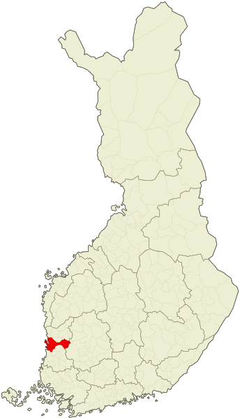
English: Location of the city of Pori, Finland as of 2015, after the consolidation with the municipality of Lavia.
Suomi: Porin kaupungin sijainti vuoden 2015 kuntajaon mukaan, Lavian kuntaliitoksen jälkeen. |
| Dagsetning | |
| Uppruni | File:Suomi.karttapohja.2015.svg |
| Höfundarréttarhafi | Care, Apalsola |
| SVG genesis |
Leyfisupplýsingar:
| I, the copyright holder of this work, release this work into the public domain. This applies worldwide. In some countries this may not be legally possible; if so: I grant anyone the right to use this work for any purpose, without any conditions, unless such conditions are required by law. |
Breytingaskrá skjals
Smelltu á dagsetningu eða tímasetningu til að sjá hvernig hún leit þá út.
| Dagsetning/Tími | Smámynd | Víddir | Notandi | Athugasemd | |
|---|---|---|---|---|---|
| núverandi | 11. janúar 2015 kl. 18:45 | | 1.850 × 3.220 (216 KB) | Heraldia | Anttoora/Lampaluoto/Pastuskari/Reposaari island |
| 6. janúar 2015 kl. 17:33 |  | 1.850 × 3.220 (216 KB) | Apalsola | {{Information |Description ={{en|1=Location of the city of Pori, Finland as of 2015, after the consolidation with the municipality of Lavia.}} {{fi|1=Porin kaupungin sijainti vuoden 2015 kuntajaon mukaan, Lavian kuntaliitoksen jälkeen.}} |Source... |
Skráartenglar
Eftirfarandi síða notar þessa skrá:
Altæk notkun skráar
Eftirfarandi wikar nota einnig þessa skrá:
- Notkun á ar.wikipedia.org
- Notkun á arz.wikipedia.org
- Notkun á ca.wikipedia.org
- Notkun á da.wikipedia.org
- Notkun á de.wikipedia.org
- Notkun á diq.wikipedia.org
- Notkun á el.wikipedia.org
- Notkun á es.wikipedia.org
- Notkun á et.wikipedia.org
- Notkun á ga.wikipedia.org
- Notkun á gl.wikipedia.org
- Notkun á la.wikipedia.org
- Notkun á lmo.wikipedia.org
- Notkun á mdf.wikipedia.org
- Notkun á pt.wikipedia.org
- Notkun á ro.wikipedia.org
- Notkun á se.wikipedia.org
- Notkun á th.wikipedia.org
- Notkun á tt.wikipedia.org
- Notkun á uk.wikipedia.org
- Notkun á vo.wikipedia.org
- Notkun á www.wikidata.org