
Mynd:Partitions of Poland.png

Stærð þessarar forskoðunar: 765 × 600 mynddílar Aðrar upplausnir: 306 × 240 mynddílar | 612 × 480 mynddílar | 980 × 768 mynddílar | 1.280 × 1.004 mynddílar | 2.000 × 1.568 mynddílar.
Upphafleg skrá (2.000 × 1.568 mynddílar, skráarstærð: 261 KB, MIME-gerð: image/png)
| Lýsing |
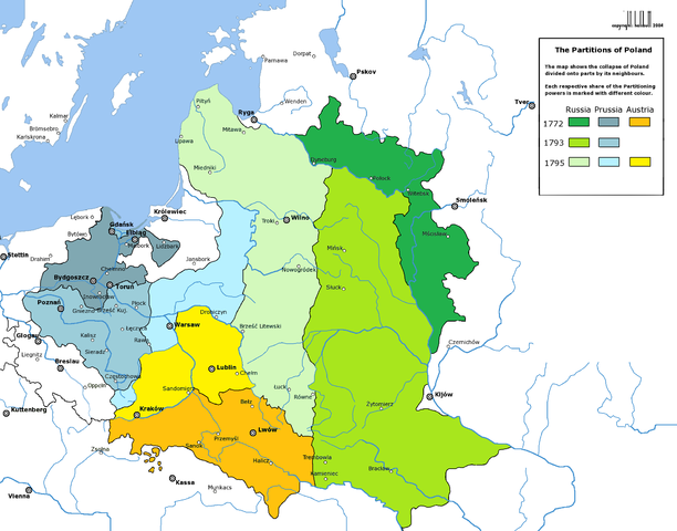
English: Partitions of the Polish-Lithuanian Commonwealth in 1772, 1793 and 1795.
Deutsch: Die Teilungen Polen-Litauens 1772, 1793 und 1795. |
| Dagsetning | (UTC) |
| Uppruni | |
| Höfundarréttarhafi |
|
| Aðrar útgáfur | العربيَّة |
| This is a retouched picture, which means that it has been digitally altered from its original version. Modifications: new colours. The original can be viewed here: Rzeczpospolita Rozbiory 3.png:
|

|
This historical map image could be re-created using vector graphics as an SVG file. This has several advantages; see Commons:Media for cleanup for more information. If an SVG form of this image is available, please upload it and afterwards replace this template with
{{vector version available|new image name}}.
It is recommended to name the SVG file “Partitions of Poland.svg”—then the template Vector version available (or Vva) does not need the new image name parameter. |
I, the copyright holder of this work, hereby publish it under the following license:

|
Gefið er leyfi til að afrita, dreifa og/eða breyta þessu skjali samkvæmt Frjálsa GNU Free Documentation License, útgáfu 1.2 eða nýrri, sem gefið er út af Frjálsu hugbúnaðarstofnuninni með engum breytingum þar á. Afrit af leyfinu er innifalið í kaflanum GNU Free Documentation License. |
| Þessi skrá er með Creative Commons Tilvísun-DeilaEins 3.0 Óstaðfært notkunarleyfi. | ||
| ||
| This licensing tag was added to this file as part of the GFDL licensing update. |
Original upload log
This image is a derivative work of the following images:
- File:Rzeczpospolita_Rozbiory_3.png licensed with GFDL
- 2006-02-16T21:06:11Z Tomekpe 2000x1568 (246810 Bytes) Corrected mistakes: * Silesia at the time belonged to Prussia, whereas the map shows it belonging to Austria.
- 2005-12-25T21:52:24Z Tomekpe 2000x1568 (247161 Bytes) Halibutt's graphic with changing polish-russian border (Krasny Horodok area).
- 2005-01-10T13:41:59Z Halibutt 2000x1568 (343225 Bytes) Partitions of the [[Polish-Lithuanian Commonwealth]]{{User:Halibutt/maps}}{{User:Halibutt/GFDL}}[[Category:Maps of Poland]][[Category:Historical maps]]
Uploaded with derivativeFX
Breytingaskrá skjals
Smelltu á dagsetningu eða tímasetningu til að sjá hvernig hún leit þá út.
| Dagsetning/Tími | Smámynd | Víddir | Notandi | Athugasemd | |
|---|---|---|---|---|---|
| núverandi | 13. mars 2009 kl. 07:57 | | 2.000 × 1.568 (261 KB) | Sneecs | Legendenfarben waren vertauscht |
| 5. mars 2009 kl. 20:03 |  | 2.000 × 1.568 (261 KB) | Sneecs | {{Information |Description= |Source=*File:Rzeczpospolita_Rozbiory_3.png |Date=2009-03-05 19:59 (UTC) |Author=*File:Rzeczpospolita_Rozbiory_3.png: Halibutt *derivative work: ~~~ |Permission=see below |other_versions= }} {{RetouchedPicture|new |
Skráartenglar
Eftirfarandi síða notar þessa skrá:
Altæk notkun skráar
Eftirfarandi wikar nota einnig þessa skrá:
- Notkun á als.wikipedia.org
- Notkun á ar.wikipedia.org
- Notkun á azb.wikipedia.org
- Notkun á az.wikipedia.org
- Notkun á be-tarask.wikipedia.org
- Notkun á be.wikipedia.org
- Notkun á bg.wikipedia.org
- Notkun á br.wikipedia.org
- Notkun á ca.wikipedia.org
- Notkun á cdo.wikipedia.org
- Notkun á cs.wikipedia.org
- Notkun á da.wikipedia.org
- Notkun á de.wikipedia.org
- Notkun á el.wikipedia.org
- Notkun á en.wikipedia.org
- Notkun á eo.wikipedia.org
Skoða frekari altæka notkun þessarar skráar.