
Mynd:New C-S System Overview.jpg
Það er engin hærri upplausn til.
New_C-S_System_Overview.jpg (657 × 541 mynddílar, skráarstærð: 146 KB, MIME-gerð: image/jpeg)

|
This technology image could be re-created using vector graphics as an SVG file. This has several advantages; see Commons:Media for cleanup for more information. If an SVG form of this image is available, please upload it and afterwards replace this template with
{{vector version available|new image name}}.
It is recommended to name the SVG file “New C-S System Overview.svg”—then the template Vector version available (or Vva) does not need the new image name parameter. |


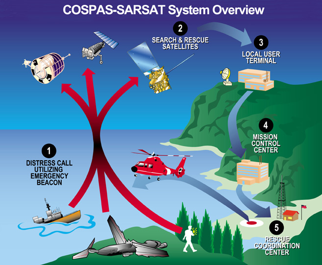
Cospas-Sarsat system overview of satellite based distress alerts using emergency beacons. Downloaded from http://www.sarsat.noaa.gov/.
This image is in the public domain because it contains materials that originally came from the U.S. National Oceanic and Atmospheric Administration, taken or made as part of an employee's official duties.
|
Breytingaskrá skjals
Smelltu á dagsetningu eða tímasetningu til að sjá hvernig hún leit þá út.
| Dagsetning/Tími | Smámynd | Víddir | Notandi | Athugasemd | |
|---|---|---|---|---|---|
| núverandi | 22. ágúst 2005 kl. 18:05 | | 657 × 541 (146 KB) | Sdo | Cospas-Sarsat system overview of satellite based distress alerts using emergency beacons. Downloaded from [http://www.sarsat.noaa.gov/ http://www.sarsat.noaa.gov/]. {{PD-USGov-NOAA}} |
Skráartenglar
Eftirfarandi síða notar þessa skrá:
Altæk notkun skráar
Eftirfarandi wikar nota einnig þessa skrá:
- Notkun á bg.wikipedia.org
- Notkun á cs.wikipedia.org
- Notkun á da.wikipedia.org
- Notkun á de.wikipedia.org
- Notkun á el.wikipedia.org
- Notkun á en.wikipedia.org
- Notkun á fi.wikipedia.org
- Notkun á fr.wikipedia.org
- Notkun á fr.wikisource.org
- Notkun á gl.wikipedia.org
- Notkun á it.wikipedia.org
- Notkun á ja.wikipedia.org
- Notkun á lv.wikipedia.org
- Notkun á nl.wikipedia.org
- Notkun á nn.wikipedia.org
- Notkun á no.wikipedia.org
- Notkun á ro.wikipedia.org
- Notkun á ru.wikipedia.org
- Notkun á ru.wikinews.org
- Notkun á sl.wikipedia.org
- Notkun á uk.wikipedia.org
- Notkun á zh.wikipedia.org