
Mynd:NPS grand-canyon-regional-map.jpg

Stærð þessarar forskoðunar: 649 × 600 mynddílar Aðrar upplausnir: 260 × 240 mynddílar | 520 × 480 mynddílar | 831 × 768 mynddílar | 1.196 × 1.105 mynddílar.
Upphafleg skrá (1.196 × 1.105 mynddílar, skráarstærð: 207 KB, MIME-gerð: image/jpeg)
Lýsing
| Lýsing |
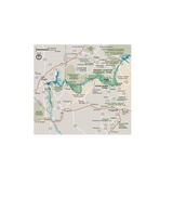
English: Need to zoom out? Here’s a map of roads near Grand Canyon, showing driving directions between the rims or to Las Vegas. |
| Dagsetning | |
| Uppruni | U.S. National Park Service (http://npmaps.com/wp-content/uploads/grand-canyon-regional-map.jpg) |
| Höfundarréttarhafi | U.S. National Park Service, restoration/cleanup by Matt Holly |
| Aðrar útgáfur |
 |
Leyfisupplýsingar:
| This image or media file contains material based on a work of a National Park Service employee, created as part of that person's official duties. As a work of the U.S. federal government, such work is in the public domain in the United States. See the NPS website and NPS copyright policy for more information. |
Breytingaskrá skjals
Smelltu á dagsetningu eða tímasetningu til að sjá hvernig hún leit þá út.
| Dagsetning/Tími | Smámynd | Víddir | Notandi | Athugasemd | |
|---|---|---|---|---|---|
| núverandi | 16. maí 2017 kl. 23:15 | | 1.196 × 1.105 (207 KB) | RKBot | =={{int:filedesc}}== {{Information |description= {{en|1=Need to zoom out? Here’s a map of roads near Grand Canyon, showing driving directions between the rims or to Las Vegas.}} |date= 2013-10-25 |source= U.S. National Park Service (http://npmaps.com... |
Skráartenglar
Eftirfarandi síða notar þessa skrá:
Altæk notkun skráar
Eftirfarandi wikar nota einnig þessa skrá:
- Notkun á en.wikipedia.org
- Notkun á gl.wikipedia.org
- Notkun á mr.wikipedia.org
- Notkun á vi.wikipedia.org