
Mynd:Myrar.svg

Stærð þessarar PNG forskoðunar á SVG skránni: 516 × 600 mynddílar. Aðrar upplausnir: 206 × 240 mynddílar | 413 × 480 mynddílar | 661 × 768 mynddílar | 881 × 1.024 mynddílar | 1.762 × 2.048 mynddílar | 622 × 723 mynddílar.
Upphafleg skrá (SVG-skrá, að nafni til 622 × 723 mynddílar, skráarstærð: 282 KB)
| I, the copyright holder of this work, release this work into the public domain. This applies worldwide. In some countries this may not be legally possible; if so: I grant anyone the right to use this work for any purpose, without any conditions, unless such conditions are required by law. |
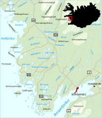
| Lýsing | Map of the region Myrar in western Iceland with several toponyms |
| Dagsetning | |
| Uppruni | eigin skrá |
| Höfundarréttarhafi | Akigka |
| Aðrar útgáfur |
|


Breytingaskrá skjals
Smelltu á dagsetningu eða tímasetningu til að sjá hvernig hún leit þá út.
| Dagsetning/Tími | Smámynd | Víddir | Notandi | Athugasemd | |
|---|---|---|---|---|---|
| núverandi | 20. apríl 2007 kl. 01:41 | | 622 × 723 (282 KB) | Akigka | {{Information |Description=Map of the region Myrar in western Iceland with several toponyms |Source=self-made |Date=April 20, 2007 |Author= Akigka |other_versions= }} Category:Maps of Iceland |
| 20. apríl 2007 kl. 01:29 |  | 622 × 723 (281 KB) | Akigka | {{Information |Description=Map of the region Myrar in western Iceland with several toponyms |Source=self-made |Date=April 20, 2007 |Author= Akigka |other_versions= }} | |
| 20. apríl 2007 kl. 01:27 |  | 744 × 1.052 (281 KB) | Akigka | {{Information |Description=Map of the region Myrar in western Iceland with several toponyms |Source=self-made |Date=April 20, 2007 |Author= ~~~ |other_versions= }} |
Skráartenglar
Eftirfarandi síða notar þessa skrá:
Altæk notkun skráar
Eftirfarandi wikar nota einnig þessa skrá:
- Notkun á sv.wikipedia.org