
Mynd:Mt Vesuvius 79 AD eruption.svg

Stærð þessarar PNG forskoðunar á SVG skránni: 800 × 482 mynddílar. Aðrar upplausnir: 320 × 193 mynddílar | 640 × 386 mynddílar | 1.024 × 617 mynddílar | 1.280 × 771 mynddílar | 2.560 × 1.542 mynddílar.
Upphafleg skrá (SVG-skrá, að nafni til 800 × 482 mynddílar, skráarstærð: 87 KB)
Lýsing
| Lýsing |
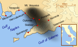
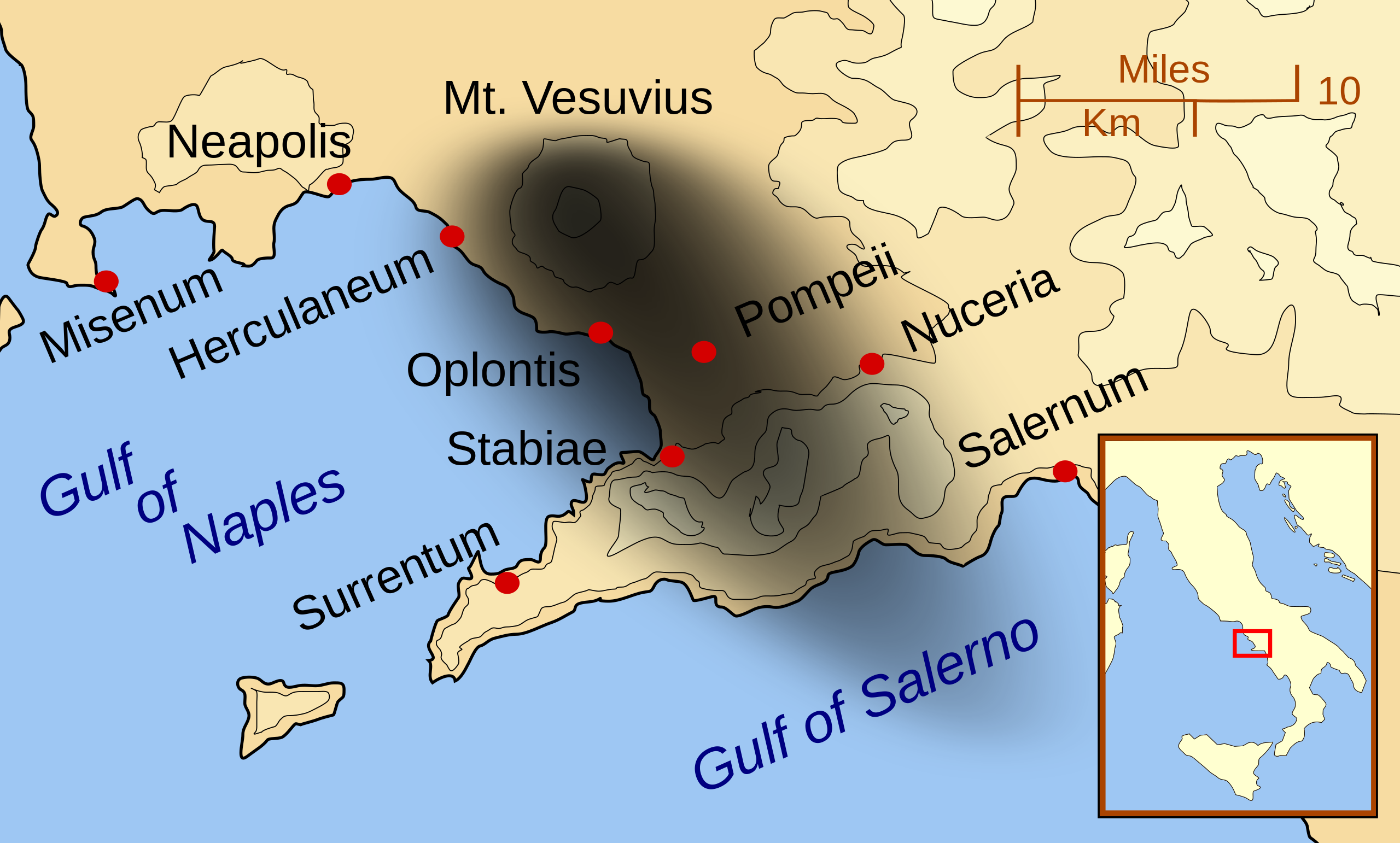
English: A map showing the cities and towns affected by the eruption of Mount Vesuvius in 79 AD. The general shape of the ash and cinder fall (see w:en:pyroclast) is shown by the dark area to the southeast of Mt Vesuvius. (P.S. It seems strange to show the modern day English names for the two bodies of water - I am open to suggestions).
This map shows lines and uses the Mercator projection (although that is not important on a map of this scale). North is, as usual, at the top of the map. |
| Dagsetning | |
| Uppruni | eigin skrá |
| Höfundarréttarhafi | MapMaster |
| Aðrar útgáfur |
[]
|


|
This SVG file contains embedded text that can be translated into your language, using any capable SVG editor, text editor or the SVG Translate tool. For more information see: About translating SVG files. |
Leyfisupplýsingar:
I, the copyright holder of this work, hereby publish it under the following licenses:

|
Gefið er leyfi til að afrita, dreifa og/eða breyta þessu skjali samkvæmt Frjálsa GNU Free Documentation License, útgáfu 1.2 eða nýrri, sem gefið er út af Frjálsu hugbúnaðarstofnuninni með engum breytingum þar á. Afrit af leyfinu er innifalið í kaflanum GNU Free Documentation License. |
This file is licensed under the Creative Commons Attribution-Share Alike 3.0 Unported, 2.5 Generic, 2.0 Generic and 1.0 Generic license.
- Þér er frjálst:
- að deila – að afrita, deila og yfirfæra verkið
- að blanda – að breyta verkinu
- Undir eftirfarandi skilmálum:
- tilvísun höfundarréttar – Þú verður að tilgreina viðurkenningu á höfundarréttindum, gefa upp tengil á notkunarleyfið og gefa til kynna ef breytingar hafa verið gerðar. Þú getur gert þetta á einhvern ásættanlegan máta, en ekki á nokkurn þann hátt sem bendi til þess að leyfisveitandinn styðji þig eða notkun þína á verkinu.
- Deila eins – Ef þú breytir, yfirfærir eða byggir á þessu efni, þá mátt þú eingöngu dreifa því verki með sama eða svipuðu leyfi og upprunalega verkið er með.
Þú mátt velja notkunarleyfi að eigin vali.
| Annotations | This image is annotated: View the annotations at Commons |
Breytingaskrá skjals
Smelltu á dagsetningu eða tímasetningu til að sjá hvernig hún leit þá út.
| Dagsetning/Tími | Smámynd | Víddir | Notandi | Athugasemd | |
|---|---|---|---|---|---|
| núverandi | 24. febrúar 2014 kl. 01:55 | | 800 × 482 (87 KB) | Ras67 | ditto |
| 24. febrúar 2014 kl. 01:42 |  | 644 × 388 (88 KB) | Ras67 | frame removed | |
| 16. október 2007 kl. 01:07 |  | 652 × 396 (113 KB) | MapMaster | corrected mis-named Gulf of Salerno | |
| 15. október 2007 kl. 04:02 |  | 652 × 396 (112 KB) | MapMaster | Dropped Title sqaure, and added towns and names of the 2 bays. | |
| 14. október 2007 kl. 05:16 |  | 652 × 454 (126 KB) | MapMaster | Minor changes made after seeing how it's rendered by Wikimedia | |
| 14. október 2007 kl. 05:11 |  | 355 × 247 (125 KB) | MapMaster | {{Information |Description=A map showing the cities and town affected by the eruption of Mount Vesuvius in 79 AD. The general shape of the ash and cinder fall is shown by the dark area to the southeast of Mt Vesuvious. |Source=self-made |Date=October 200 |
Skráartenglar
Eftirfarandi 2 síður nota þessa skrá:
Altæk notkun skráar
Eftirfarandi wikar nota einnig þessa skrá:
- Notkun á ar.wikipedia.org
- Notkun á bn.wikipedia.org
- Notkun á ca.wikipedia.org
- Notkun á cs.wikipedia.org
- Notkun á da.wikipedia.org
- Notkun á de.wikipedia.org
- Notkun á el.wikipedia.org
- Notkun á en.wikipedia.org
- Notkun á eo.wikipedia.org
- Notkun á es.wikipedia.org
- Notkun á eu.wikipedia.org
- Notkun á fa.wikipedia.org
- Notkun á fi.wikipedia.org
- Notkun á fr.wikipedia.org
- Notkun á ga.wikipedia.org
- Notkun á gl.wikipedia.org
- Notkun á he.wikipedia.org
- Notkun á hr.wikipedia.org
- Notkun á hu.wikipedia.org
- Notkun á hyw.wikipedia.org
- Notkun á id.wikipedia.org
- Notkun á it.wikipedia.org
Skoða frekari altæka notkun þessarar skráar.