
Mynd:Middle-settlement.png
Það er engin hærri upplausn til.
Middle-settlement.png (638 × 447 mynddílar, skráarstærð: 140 KB, MIME-gerð: image/png)
Lýsing
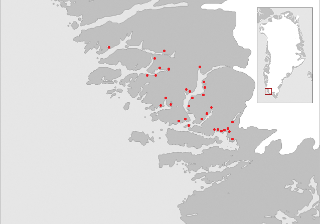
| Lýsing | Map of the "Middle settlement" of the Norse in medieval Greenland. No written documents of this settlement exist and the name Middle settlement is constructed by modern archaeologists. The red dots indicate known Norse farm ruins. |
| Dagsetning | |
| Uppruni |
Saga trails, Jette Arneborg, Danmarks Nationalmuseum, ISBN: 87-988378-3-4 Grønlands forhistorie,red. Hans Christian Gulløv, Gyldendal 2005, ISBN:87-02-01724-5 Á hjara veraldar, Guðmundur J. Guðmundsson, Sögufélagið, 2005, ISBN: 9979-9636-8-9 |
| Höfundarréttarhafi | Masae |
| Réttindi (Endurnotkun á þessari skrá) |
Own work |
Leyfisupplýsingar:
I, the copyright holder of this work, hereby publish it under the following licenses:

|
Gefið er leyfi til að afrita, dreifa og/eða breyta þessu skjali samkvæmt Frjálsa GNU Free Documentation License, útgáfu 1.2 eða nýrri, sem gefið er út af Frjálsu hugbúnaðarstofnuninni með engum breytingum þar á. Afrit af leyfinu er innifalið í kaflanum GNU Free Documentation License. |
| Þessi skrá er með Creative Commons Tilvísun-DeilaEins 3.0 Óstaðfært notkunarleyfi. | ||
| ||
| This licensing tag was added to this file as part of the GFDL licensing update. |
This file is licensed under the Creative Commons Attribution-Share Alike 2.5 Generic, 2.0 Generic and 1.0 Generic license.
- Þér er frjálst:
- að deila – að afrita, deila og yfirfæra verkið
- að blanda – að breyta verkinu
- Undir eftirfarandi skilmálum:
- tilvísun höfundarréttar – Þú verður að tilgreina viðurkenningu á höfundarréttindum, gefa upp tengil á notkunarleyfið og gefa til kynna ef breytingar hafa verið gerðar. Þú getur gert þetta á einhvern ásættanlegan máta, en ekki á nokkurn þann hátt sem bendi til þess að leyfisveitandinn styðji þig eða notkun þína á verkinu.
- Deila eins – Ef þú breytir, yfirfærir eða byggir á þessu efni, þá mátt þú eingöngu dreifa því verki með sama eða svipuðu leyfi og upprunalega verkið er með.
Þú mátt velja notkunarleyfi að eigin vali.
Breytingaskrá skjals
Smelltu á dagsetningu eða tímasetningu til að sjá hvernig hún leit þá út.
| Dagsetning/Tími | Smámynd | Víddir | Notandi | Athugasemd | |
|---|---|---|---|---|---|
| núverandi | 8. desember 2006 kl. 08:54 | | 638 × 447 (140 KB) | Masae~commonswiki | {{Information |Description=Map of the "Middle settlement" of the Norse in medieval Greenland. No written documents of this settlement exist and the name Middle settlement is constructed by modern archaeologists. The red dots indicate known Norse farm ruin |
| 7. desember 2006 kl. 16:23 |  | 638 × 510 (86 KB) | Masae~commonswiki | {{Information |Description=Map of the "Middle settlement" of the Norse in medieval Greenland. No written documents of this settlement exist and the name Middle settlement is constructed by modern archaeologists. The red dots indicate known Norse farm ruin | |
| 7. desember 2006 kl. 15:46 |  | 638 × 603 (83 KB) | Masae~commonswiki | {{Information |Description=Map of the "Middle settlement" of the Norse in medieval Greenland. No written documents of this settlement exist and the name Middle settlement is constructed by modern archaeologists. |Source=Saga trails, Jette Arneborg, Danma |
Skráartenglar
Eftirfarandi 3 síður nota þessa skrá:
Altæk notkun skráar
Eftirfarandi wikar nota einnig þessa skrá:
- Notkun á ca.wikipedia.org
- Notkun á da.wikipedia.org
- Notkun á de.wikipedia.org
- Notkun á en.wikipedia.org
- Notkun á es.wikipedia.org
- Notkun á fi.wikipedia.org
- Notkun á fr.wikipedia.org
- Notkun á uk.wikipedia.org